
Lorient Surf Guide
Lorient in Saint Barthélemy is a reasonably exposed reef break that has reasonably consistent surf. The best wind direction is from the southeast. The best swell direction is from the northeast. Beware of - Rips / undertow - Rocks.
Lorient Spot Info
| Type: | Rating: | Reliability: | Todays Sea Temp*: |
|---|---|---|---|
| fairly consistent | 28.6°C*ocean temperature recorded from satellite |
Surfing Lorient:
The best conditions reported for surf at Lorient occur when a Northeast swell combines with an offshore wind direction from the Southeast.

Previsioni Energia d'onda (Potenza): 12hrs


Lorient Surf:
Sunday, 19 July 2026, 00:31 Local time| Domenica 19 | ||||
| 11PM | 2AM | 5AM | 8AM | |
| Wave (m) | ||||
| Periodo (s) | 7 | 8 | 8 | 8 |
| Vento (km/h) | ||||
| Stato del vento | cross- off |
cross- off |
cross- off |
cross- off |
- /breaks/Lorient/forecasts/latest

Lorient Surf Guide
Lorient in Saint Barthélemy is a reasonably exposed reef break that has reasonably consistent surf. The best wind direction is from the southeast. The best swell direction is from the northeast. Beware of - Rips / undertow - Rocks.
Lorient Spot Info
Type: Rating: Reliability: Todays Sea Temp*:  Reef
Reef 2
2fairly consistent 28.6°C*ocean temperature recorded from satelliteSurfing Lorient:
The best conditions reported for surf at Lorient occur when a Northeast swell combines with an offshore wind direction from the Southeast.
Previsioni Energia d'onda (Potenza): 12hrs
Utilizzare la scheda di navigazione in alto per visualizzare Lorient temperatura del mare, Lorient fotografie, Lorient dettagliate previsioni onde, il vento e le previsioni meteo, Lorient webcam, vento corrente da Saint Barthélemy stazioni meteo e Lorient previsioni marea. Il link Saint Barthélemy mappe maree apre l'immagine grande, che mostra Saint Barthélemy e dei mari circostanti. Queste mappe possono essere animate per mostrare le diverse componenti del moto ondoso, energia delle onde, periodo d'onda, altezza delle onde, insieme con le previsioni del vento e meteo, meteo corrente e osservazioni sullo stato del mare dal Saint Barthélemy onda-boe, le navi passanti e stazioni meteo costiere. Ciascuna delle pagine di previsioni per questo surf break rappresenta uno strumento di wavefinder globale e regionale per individuare le migliori condizioni di surf nella zona intorno Lorient.
Lorient Surf:
Sunday, 19 July 2026, 00:31 Local timeDomenica 19 11PM 2AM 5AM 8AM Wave (m) Periodo (s) 7 8 8 8 Vento (km/h) Stato del vento cross-
offcross-
offcross-
offcross-
off- /breaks/Lorient/forecasts/latest
- /breaks/Lorient/forecasts/latest/six_day
Lorient Surf Guide
Lorient in Saint Barthélemy is a reasonably exposed reef break that has reasonably consistent surf. The best wind direction is from the southeast. The best swell direction is from the northeast. Beware of - Rips / undertow - Rocks.
Lorient Spot Info
Type: Rating: Reliability: Todays Sea Temp*: Reef2fairly consistent 28.6°C*ocean temperature recorded from satelliteSurfing Lorient:
The best conditions reported for surf at Lorient occur when a Northeast swell combines with an offshore wind direction from the Southeast.
Previsioni Energia d'onda (Potenza): 12hrs
Utilizzare la scheda di navigazione in alto per visualizzare Lorient temperatura del mare, Lorient fotografie, Lorient dettagliate previsioni onde, il vento e le previsioni meteo, Lorient webcam, vento corrente da Saint Barthélemy stazioni meteo e Lorient previsioni marea. Il link Saint Barthélemy mappe maree apre l'immagine grande, che mostra Saint Barthélemy e dei mari circostanti. Queste mappe possono essere animate per mostrare le diverse componenti del moto ondoso, energia delle onde, periodo d'onda, altezza delle onde, insieme con le previsioni del vento e meteo, meteo corrente e osservazioni sullo stato del mare dal Saint Barthélemy onda-boe, le navi passanti e stazioni meteo costiere. Ciascuna delle pagine di previsioni per questo surf break rappresenta uno strumento di wavefinder globale e regionale per individuare le migliori condizioni di surf nella zona intorno Lorient.
Lorient Surf:
Sunday, 19 July 2026, 00:31 Local timeDomenica 19 11PM 2AM 5AM 8AM Wave (m) Periodo (s) 7 8 8 8 Vento (km/h) Stato del vento cross-
offcross-
offcross-
offcross-
off- /breaks/Lorient/forecasts/latest
Lorient Surf Guide
Lorient in Saint Barthélemy is a reasonably exposed reef break that has reasonably consistent surf. The best wind direction is from the southeast. The best swell direction is from the northeast. Beware of - Rips / undertow - Rocks.
Lorient Spot Info
Type: Rating: Reliability: Todays Sea Temp*: Reef2fairly consistent 28.6°C*ocean temperature recorded from satelliteSurfing Lorient:
The best conditions reported for surf at Lorient occur when a Northeast swell combines with an offshore wind direction from the Southeast.
Previsioni Energia d'onda (Potenza): 12hrs
Utilizzare la scheda di navigazione in alto per visualizzare Lorient temperatura del mare, Lorient fotografie, Lorient dettagliate previsioni onde, il vento e le previsioni meteo, Lorient webcam, vento corrente da Saint Barthélemy stazioni meteo e Lorient previsioni marea. Il link Saint Barthélemy mappe maree apre l'immagine grande, che mostra Saint Barthélemy e dei mari circostanti. Queste mappe possono essere animate per mostrare le diverse componenti del moto ondoso, energia delle onde, periodo d'onda, altezza delle onde, insieme con le previsioni del vento e meteo, meteo corrente e osservazioni sullo stato del mare dal Saint Barthélemy onda-boe, le navi passanti e stazioni meteo costiere. Ciascuna delle pagine di previsioni per questo surf break rappresenta uno strumento di wavefinder globale e regionale per individuare le migliori condizioni di surf nella zona intorno Lorient.
Lorient Surf:
Sunday, 19 July 2026, 00:31 Local timeDomenica 19 11PM 2AM 5AM 8AM Wave (m) Periodo (s) 7 8 8 8 Vento (km/h) Stato del vento cross-
offcross-
offcross-
offcross-
offTide Times:
Per Saint Barthelemy, Guadeloupe, %{dist} %{km} da %{location}.
PROSSIMA È ALLE (ora locale) rimanente alta marea bassa marea Lorient Tide Times and Tide Chart
Live Weather:
At Gustavia wx, 2 km from Lorient.
light winds from the NE
(km/h)
dryAir temperature
-°CBuoy Data:
At Eastern Caribbean Buoy, 107 miles from Lorient.
8PM 9PM 10PM 11PM Attualità dei dati 4 hr 3 hr 2 hr 1 hr Altezza delle onde (m) 


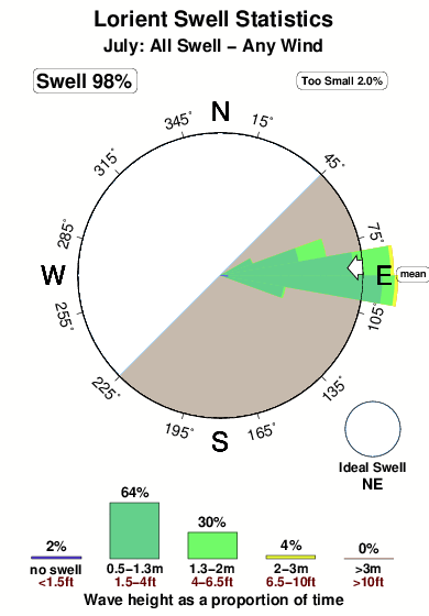
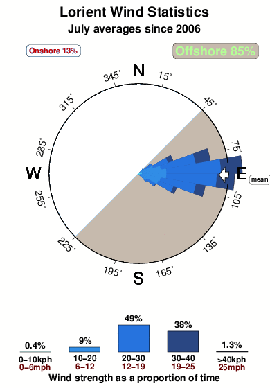
Periodo dominante (s) 8 6 7 - Overall Lorient Surf Consistency and Wind Distribution in Luglio
foto dall' album
Contorni: Strade e fiumi: seleziona un surf break dal menu 


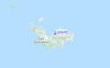
Utilizzare questa mappa sollievo per navigare Saint Barthélemy surf breaks e stazioni di marea che si trovano nella zona diLorient
Altri surf breaks più vicini al Lorient:
(clicca sul nome del luogo per maggiori informazioni)- Closest località surf0 mi
- Second closest località surf1 mi
- Third closest località surf1 mi
- Fourth closest località surf1 mi
- Fifth closest località surf1 mi
Onda boe più vicina a Lorient:
- Closest Onda boa107 mi
- Second closest Onda boa129 mi
- Third closest Onda boa175 mi
- Fourth closest Onda boa219 mi
- Fifth closest Onda boa243 mi
Stazioni di marea più vicina alla Lorient:
- Closest marea stazioneSaint Barthelemy2 mi
- Second closest marea stazioneDuth Cul de Sac18 mi
- Third closest marea stazioneMarigot21 mi
- Fourth closest marea stazioneBasseterre43 mi
- Fifth closest marea stazioneSaint Johns, Antigua83 mi
Airports
- The closest passenger airport to Lorient is Gustavia/st.barthel (St.-barthelemy) Airport (SBH) in Antilles, 3 km (2 miles) away (directly).
- The second nearest airport to Lorient is Grand Case (St. Martin) Airport (SFG), also in Antilles, 32 km (20 miles) away.
- Third is Princess Juliana International (Philipsburg) Airport (SXM) in Antilles, 33 km (20 miles) away.
- Wallblake (The Valley) Airport (AXA) in Anguilla Isl. is 41 km (25 miles) away.
- F D Roosevelt (Oranjestad) Airport (EUX) in Antilles is the fifth nearest airport to Lorient and is 49 km (30 miles) away.

- /breaks/Lorient/forecasts/latest


 Nearest