
Previsioni:

Previsione a breve termineQualche pioggerella, più pesante durante lunedì notte. Warm (Max 31°C martedì pomeriggio, Min 26°C Domenica mattina). Vento sarà generalmente leggero. | |||||||||||||||||||
Dom 2 | Lunedì 3 | Martedì 4 | |||||||||||||||||
5 PM | 8 PM | 11 PM | 2 AM | 5 AM | 8 AM | 11 AM | 2 PM | 5 PM | 8 PM | 11 PM | 2 AM | 5 AM | 8 AM | 11 AM | 2 PM | 5 PM | 8 PM | 11 PM | |
Mappa dell'altezza del moto ondoso | 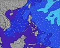 | 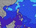 | 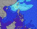 | 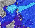 | 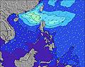 | 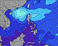 | 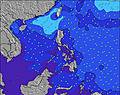 | ||||||||||||
Onda Altezza (m) Direzione Periodo (s) | E 19 | E 17 | E 18 | E 18 | ENE 15 | ENE 16 | ENE 16 | ENE 15 | ENE 15 | E 15 | E 16 | ENE 16 | ENE 15 | ENE 16 | ENE 16 | ENE 17 | ENE 18 | ENE 17 | ENE 16 |
Grafico delle onde | |||||||||||||||||||
66 | 146 | 222 | 158 | 308 | 416 | 421 | 375 | 284 | 566 | 596 | 749 | 702 | 871 | 1091 | 1201 | 1447 | 1668 | 1500 | |
Vento (km/h) | |||||||||||||||||||
Stato del vento onshore cross-onshore cross-shore cross-offshore offshore piatto | off | off | cross-off | off | cross-off | cross-off | cross-off | cross-off | cross-off | off | cross-off | cross-off | cross-off | cross-off | cross-off | cross-off | cross-off | cross-off | cross-off |
Alta Marea | 8:11PM1.75m | 8:12AM1.71m | 8:40PM1.75m | 8:54AM1.60m | 9:13PM1.73m | ||||||||||||||
Basso Marea | 2:12AM0.48m | 2:23PM0.37m | 2:52AM0.47m | 2:56PM0.49m | |||||||||||||||
— | — | — | — | 5:26 | — | — | — | — | — | — | — | 5:26 | — | — | — | — | — | — | |
6:09 | — | — | — | — | — | — | — | 6:08 | — | — | — | — | — | — | — | 6:08 | — | — | |
mm | — | — | — | — | — | — | — | — | — | 1 | — | — | — | — | — | — | — | — | — |
Temp. °C | 27 | 26 | 26 | 26 | 26 | 28 | 29 | 30 | 29 | 28 | 27 | 27 | 26 | 28 | 30 | 31 | 30 | 28 | 27 |
Gelo °C | 29 | 28 | 29 | 28 | 28 | 30 | 30 | 30 | 30 | 31 | 29 | 30 | 28 | 29 | 30 | 32 | 31 | 30 | 29 |
Onda 1 Altezza (m) Direzione Periodo (s) | NNW 5 | E 17 | E 18 | E 15 | ENE 15 | ENE 16 | ENE 16 | ENE 15 | ENE 15 | E 15 | E 16 | ENE 16 | ENE 15 | ENE 16 | ENE 16 | ENE 17 | ENE 18 | ENE 17 | ENE 16 |
5 | 146 | 222 | 109 | 308 | 416 | 421 | 375 | 284 | 566 | 596 | 749 | 702 | 871 | 1091 | 1201 | 1447 | 1668 | 1500 | |
Onda 2 Altezza (m) Direzione Periodo (s) | E 19 | NW 5 | NW 6 | E 18 | NNW 6 | NW 6 | NNW 6 | SE 8 | E 18 | ENE 8 | ENE 8 | SE 8 | SE 8 | SE 9 | SE 7 | SE 9 | SSE 9 | SSE 9 | SE 9 |
66 | 10 | 8 | 158 | 12 | 12 | 6 | 11 | 222 | 7 | 7 | 11 | 9 | 12 | 8 | 12 | 8 | 8 | 12 | |
Onda 3 Altezza (m) Direzione Periodo (s) | E 16 | ENE 9 | ENE 9 | NW 6 | ENE 9 | E 9 | ENE 9 | ENE 8 | ENE 8 | N 6 | SSE 8 | ESE 10 | ENE 8 | — | ESE 10 | ESE 10 | ESE 10 | ESE 10 | ESE 10 |
45 | 15 | 15 | 9 | 15 | 13 | 7 | 7 | 7 | 3 | 6 | 9 | 6 | — | 9 | 9 | 9 | 9 | 9 | |
onde vento Altezza (m) Direzione Periodo (s) | WSW 3 | SW 4 | SW 4 | SSW 3 | SSW 3 | SSW 4 | SSW 4 | SSW 3 | SSW 4 | S 4 | SSW 4 | SW 4 | SW 4 | SSW 4 | SSW 4 | SSW 5 | SSW 4 | SSW 4 | SSW 5 |
2 | 5 | 4 | 1 | 1 | 9 | 4 | 7 | 8 | 9 | 11 | 10 | 7 | 6 | 11 | 20 | 16 | 16 | 17 | |
Il più vicino Offshore or Glassy | |||||||||||||||||||
Distanza (km) | 0 | 0 | 0 | 0 | 0 | 0 | 3 | 3 | 3 | 0 | 0 | 0 | 0 | 3 | 3 | 3 | 3 | 3 | 3 |
Migliori previsioni per le condizioni d'onda in Catanduanes | |||||||||||||||||||
Migliori previsioni per le condizioni d'onda in Philippines | |||||||||||||||||||
Trova Onde Globale | |||||||||||||||||||
- Map Icons:
 Break
Break Live Wave Height (m)
 Live Wind Speed (km/h)
 Surf Rating (10 Max)
 Ocean Swells (m)
- Wind Speed (km/h)
Widget Free Surf-Forecast.com per il tuo sito
La relazione di surf / widget meteo è disponibile qui sotto per incorporare su siti esterni a titolo gratuito e fornisce una sintesi delle nostre Lucky Point previsione surf. Basta prendere il frammento di codice html da noi fornito e copiarlo nel proprio sito. È possibile scegliere la lingua preferita e unità metriche / imperiali per il feed delle previsioni surf per soddisfare le esigenze degli utenti del vostro sito .... Clicca qui per ottenere il codice.
 Nearest