
Previsioni:

Previsione a breve terminePioggia abbondante (Totale 27mm), più pesante durante lunedì notte. Warm (Max 30°C martedì mattina, Min 28°C Lunedì notte). Venti in aumento (venti deboli da NE Lunedì notte, Burrasca da NNW per giovedì pomeriggio). | ||||||||||||||||||
Lun 3 | Martedì 4 | Mercoledì 5 | ||||||||||||||||
6 PM | 9 PM | 12 AM | 3 AM | 6 AM | 9 AM | 12 PM | 3 PM | 6 PM | 9 PM | 12 AM | 3 AM | 6 AM | 9 AM | 12 PM | 3 PM | 6 PM | 9 PM | |
Mappa dell'altezza del moto ondoso |  |  | 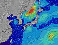 |  |  | 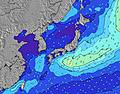 |  | |||||||||||
Onda Altezza (m) Direzione Periodo (s) | NNE 3 | N 3 | N 4 | E 16 | E 17 | E 18 | E 17 | E 17 | E 18 | E 18 | E 17 | E 17 | E 16 | E 17 | E 17 | E 18 | E 18 | E 18 |
Grafico delle onde | ||||||||||||||||||
3 | 6 | 11 | 507 | 724 | 733 | 861 | 1009 | 1183 | 1375 | 1543 | 1311 | 1372 | 1663 | 1929 | 2174 | 2973 | 4247 | |
Vento (km/h) | ||||||||||||||||||
Stato del vento onshore cross-onshore cross-shore cross-offshore offshore piatto | cross-on | cross | cross | cross | cross-off | cross-off | cross | cross-off | cross-off | cross-off | cross-off | cross-off | cross-off | cross-off | cross | cross | cross | cross |
Alta Marea | 10:15PM2.05m | 10:30AM1.94m | 10:49PM2.01m | 11:26AM1.80m | ||||||||||||||
Basso Marea | 4:00PM0.51m | 4:26AM0.63m | 4:37PM0.68m | 5:16AM0.63m | 5:17PM0.88m | |||||||||||||
— | — | — | 5:54 | — | — | — | — | — | — | — | 5:54 | — | — | — | — | — | — | |
7:15 | — | — | — | — | — | — | — | 7:14 | — | — | — | — | — | — | — | 7:14 | — | |
mm | — | — | 1 | 4 | 2 | 2 | — | 2 | 1 | 1 | 1 | — | 1 | 2 | — | 1 | 1 | — |
Temp. °C | 30 | 29 | 29 | 29 | 28 | 29 | 30 | 30 | 29 | 29 | 28 | 28 | 28 | 29 | 30 | 29 | 29 | 29 |
Gelo °C | 32 | 31 | 31 | 32 | 31 | 31 | 33 | 33 | 31 | 32 | 31 | 30 | 31 | 31 | 31 | 29 | 29 | 29 |
Onda 1 Altezza (m) Direzione Periodo (s) | ESE 16 | ESE 16 | E 16 | E 16 | E 17 | E 18 | E 17 | E 17 | E 18 | E 18 | E 17 | E 17 | E 16 | E 17 | E 17 | E 18 | E 18 | E 18 |
432 | 416 | 516 | 507 | 724 | 733 | 861 | 1009 | 1183 | 1375 | 1543 | 1311 | 1372 | 1663 | 1929 | 2174 | 2973 | 4247 | |
Onda 2 Altezza (m) Direzione Periodo (s) | S 7 | S 7 | SW 7 | S 8 | S 8 | N 5 | N 5 | S 8 | S 8 | — | — | S 8 | S 8 | S 8 | S 8 | S 7 | S 7 | — |
1 | 1 | 2 | 1 | 5 | 12 | 12 | 6 | 5 | — | — | 5 | 5 | 5 | 4 | 4 | 4 | — | |
Onda 3 Altezza (m) Direzione Periodo (s) | SW 7 | SW 7 | SE 8 | SW 7 | SW 7 | S 8 | S 8 | — | — | — | — | — | — | — | SE 13 | SSW 7 | SSW 7 | — |
2 | 2 | 11 | 2 | 2 | 5 | 6 | — | — | — | — | — | — | — | 7 | 5 | 5 | — | |
onde vento Altezza (m) Direzione Periodo (s) | NNE 3 | N 3 | N 4 | N 4 | N 5 | — | — | NNE 5 | NNE 5 | NNE 5 | NNE 5 | NE 5 | NE 5 | NE 5 | NNE 6 | NNE 4 | NNE 5 | NNE 6 |
3 | 6 | 11 | 13 | 15 | — | — | 13 | 15 | 14 | 13 | 25 | 34 | 40 | 55 | 42 | 64 | 90 | |
Il più vicino Offshore or Glassy | ||||||||||||||||||
Distanza (km) | 650 | 622 | 36 | 9 | 0 | 10 | 1 | 10 | 10 | 9 | 10 | 9 | 10 | 27 | 796 | 796 | 796 | 608 |
Migliori previsioni per le condizioni d'onda in Okinawa | ||||||||||||||||||
Migliori previsioni per le condizioni d'onda in Japan | ||||||||||||||||||
Trova Onde Globale | ||||||||||||||||||
- Map Icons:
 Break
Break Live Wave Height (m)
 Live Wind Speed (km/h)
 Surf Rating (10 Max)
 Ocean Swells (m)
- Wind Speed (km/h)
Widget Free Surf-Forecast.com per il tuo sito
La relazione di surf / widget meteo è disponibile qui sotto per incorporare su siti esterni a titolo gratuito e fornisce una sintesi delle nostre Mainside previsione surf. Basta prendere il frammento di codice html da noi fornito e copiarlo nel proprio sito. È possibile scegliere la lingua preferita e unità metriche / imperiali per il feed delle previsioni surf per soddisfare le esigenze degli utenti del vostro sito .... Clicca qui per ottenere il codice.
 Nearest