
Previsioni:

Previsione a breve terminepioggia leggera (Totale 7mm), per lo più che cade Venerdì pomeriggio. Warm (Max 24°C Venerdì mattina, Min 22°C Venerdì notte). Vento sarà generalmente leggero. | ||||||||||||||||||||||
Venerdì 31 | Sabato 1 | Domenica 2 | ||||||||||||||||||||
7 AM | 10 AM | 1 PM | 4 PM | 7 PM | 10 PM | 1 AM | 4 AM | 7 AM | 10 AM | 1 PM | 4 PM | 7 PM | 10 PM | 1 AM | 4 AM | 7 AM | 10 AM | 1 PM | 4 PM | 7 PM | 10 PM | |
Mappa dell'altezza del moto ondoso |  | 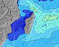 | 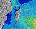 | 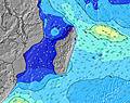 | 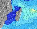 | 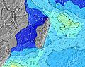 | 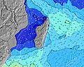 | 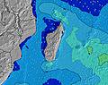 | ||||||||||||||
Onda Altezza (m) Direzione Periodo (s) | E 10 | E 9 | E 9 | E 9 | E 8 | E 8 | E 8 | E 8 | E 8 | E 8 | E 9 | E 10 | E 10 | E 10 | E 9 | E 9 | E 9 | E 9 | E 9 | E 8 | ENE 8 | S 20 |
Grafico delle onde | ||||||||||||||||||||||
268 | 270 | 286 | 291 | 271 | 266 | 298 | 260 | 260 | 260 | 247 | 363 | 313 | 284 | 390 | 390 | 399 | 351 | 390 | 401 | 257 | 377 | |
Vento (km/h) | ||||||||||||||||||||||
Stato del vento onshore cross-onshore cross-shore cross-offshore offshore piatto | cross-off | cross-off | glassy | cross | cross-off | cross-off | cross-off | cross-off | cross-off | cross-off | cross | cross | cross-off | cross-off | cross-off | cross-off | cross-off | cross-off | cross | cross-off | cross-off | cross-off |
Alta Marea | 1:51PM0.58m | 1:40AM0.66m | 2:17PM0.60m | 2:09AM0.65m | 2:44PM0.60m | |||||||||||||||||
Basso Marea | 7:42AM0.03m | 7:38PM0.14m | 8:06AM0.04m | 8:06PM0.15m | 8:31AM0.06m | 8:37PM0.16m | ||||||||||||||||
6:50 | — | — | — | — | — | — | 6:48 | — | — | — | — | — | — | — | 6:48 | — | — | — | — | — | — | |
— | — | — | 5:58 | — | — | — | — | — | — | — | 5:58 | — | — | — | — | — | — | — | 5:58 | — | — | |
mm | — | — | — | 1 | — | 1 | — | — | — | — | — | — | — | — | 1 | — | — | — | — | — | 1 | — |
Temp. °C | 22 | 23 | 24 | 23 | 23 | 23 | 22 | 22 | 22 | 24 | 24 | 24 | 23 | 23 | 22 | 22 | 22 | 24 | 24 | 24 | 23 | 23 |
Gelo °C | 22 | 24 | 26 | 25 | 24 | 24 | 22 | 22 | 22 | 24 | 24 | 24 | 23 | 23 | 22 | 21 | 21 | 23 | 24 | 24 | 22 | 22 |
Onda 1 Altezza (m) Direzione Periodo (s) | SW 16 | SW 16 | SW 16 | SW 15 | SSW 15 | SSW 15 | SW 14 | SSW 15 | SSW 15 | SSW 15 | SSW 15 | SSW 14 | SSW 14 | SSW 14 | SSW 14 | SSW 14 | SSW 14 | SSW 15 | SSW 16 | SSW 16 | SSW 15 | SW 15 |
1551 | 1551 | 1551 | 1472 | 1314 | 1158 | 1031 | 1447 | 1611 | 1589 | 1568 | 1389 | 1244 | 1042 | 1159 | 1042 | 1244 | 1332 | 1241 | 1225 | 1028 | 881 | |
Onda 2 Altezza (m) Direzione Periodo (s) | ESE 10 | ESE 10 | SE 10 | E 9 | ESE 9 | SSW 18 | SSW 17 | SE 9 | SE 9 | SE 9 | SE 9 | ESE 9 | SSW 18 | SSW 18 | SSW 18 | SSW 18 | — | S 24 | S 24 | S 22 | SE 9 | ESE 9 |
86 | 65 | 46 | 291 | 54 | 322 | 522 | 22 | 22 | 20 | 20 | 31 | 348 | 459 | 124 | 364 | — | 12 | 44 | 85 | 174 | 264 | |
Onda 3 Altezza (m) Direzione Periodo (s) | — | — | — | ESE 9 | — | SE 9 | SE 9 | — | — | SE 9 | — | — | SE 9 | SE 9 | — | S 16 | — | S 24 | — | S 22 | S 21 | S 20 |
— | — | — | 58 | — | 41 | 22 | — | — | 20 | — | — | 79 | 110 | — | 5 | — | 12 | — | 85 | 214 | 377 | |
onde vento Altezza (m) Direzione Periodo (s) | E 10 | E 9 | E 9 | — | E 8 | E 8 | E 8 | E 8 | E 8 | E 8 | E 9 | E 10 | E 10 | E 10 | E 9 | E 9 | E 9 | E 9 | E 9 | E 8 | ENE 8 | ENE 8 |
268 | 270 | 286 | — | 271 | 266 | 298 | 260 | 260 | 260 | 247 | 363 | 313 | 284 | 390 | 390 | 399 | 351 | 390 | 401 | 257 | 295 | |
Il più vicino Offshore or Glassy | ||||||||||||||||||||||
Distanza (km) | 0 | 0 | 0 | 29 | 0 | 0 | 0 | 0 | 0 | 0 | 15 | 15 | 15 | 11 | 11 | 11 | 15 | 15 | 53 | 15 | 11 | 11 |
Migliori previsioni per le condizioni d'onda in Réunion Island | ||||||||||||||||||||||
Migliori previsioni per le condizioni d'onda in Reunion | ||||||||||||||||||||||
Trova Onde Globale | ||||||||||||||||||||||
- Map Icons:
 Break
Break Live Wave Height (m)
 Live Wind Speed (km/h)
 Surf Rating (10 Max)
 Ocean Swells (m)
- Wind Speed (km/h)
Widget Free Surf-Forecast.com per il tuo sito
La relazione di surf / widget meteo è disponibile qui sotto per incorporare su siti esterni a titolo gratuito e fornisce una sintesi delle nostre Manapany previsione surf. Basta prendere il frammento di codice html da noi fornito e copiarlo nel proprio sito. È possibile scegliere la lingua preferita e unità metriche / imperiali per il feed delle previsioni surf per soddisfare le esigenze degli utenti del vostro sito .... Clicca qui per ottenere il codice.
 Nearest