

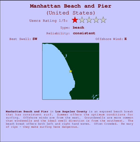
Manhattan Beach and Pier Surf Guide
Manhattan Beach and Pier in LA County is an exposed beach break that has consistent surf. Summer offers the favoured conditions for surfing. The best wind direction is from the east. Most of the surf here comes from groundswells and the ideal swell direction is from the southwest. Waves at the beach are both lefts and rights. Often Crowded. Be wary of rips - they make surfing here dangerous.
Manhattan Beach and Pier Spot Info
| Type: | Rating: | Reliability: | Todays Sea Temp*: |
|---|---|---|---|
| consistent | 21.1°C*ocean temperature recorded from satellite |
Surfing Manhattan Beach and Pier:
The best conditions reported for surf at Manhattan Beach and Pier occur when a Southwest swell combines with an offshore wind direction from the East.

Previsioni Energia d'onda (Potenza): 12hrs


Manhattan Beach and Pier Surf:
Tuesday, 14 July 2026, 16:59 Local time| Martedì 14 | ||||
| 2PM | 5PM | 8PM | 11PM | |
| Wave (m) | ||||
| Periodo (s) | 12 | 12 | 18 | 18 |
| Vento (km/h) | ||||
| Stato del vento | cross- on |
on | on | cross |
- /breaks/Manhattan-Beach-Pier/forecasts/latest
Manhattan Beach and Pier Surf Guide
Manhattan Beach and Pier in LA County is an exposed beach break that has consistent surf. Summer offers the favoured conditions for surfing. The best wind direction is from the east. Most of the surf here comes from groundswells and the ideal swell direction is from the southwest. Waves at the beach are both lefts and rights. Often Crowded. Be wary of rips - they make surfing here dangerous.
Manhattan Beach and Pier Spot Info
Type: Rating: Reliability: Todays Sea Temp*:  Beach
Beach 1
1consistent 21.1°C*ocean temperature recorded from satelliteSurfing Manhattan Beach and Pier:
The best conditions reported for surf at Manhattan Beach and Pier occur when a Southwest swell combines with an offshore wind direction from the East.
Previsioni Energia d'onda (Potenza): 12hrs
Utilizzare la scheda di navigazione in alto per visualizzare Manhattan Beach and Pier temperatura del mare, Manhattan Beach and Pier fotografie, Manhattan Beach and Pier dettagliate previsioni onde, il vento e le previsioni meteo, Manhattan Beach and Pier webcam, vento corrente da CAL - LA County stazioni meteo e Manhattan Beach and Pier previsioni marea. Il link United States mappe maree apre l'immagine grande, che mostra United States e dei mari circostanti. Queste mappe possono essere animate per mostrare le diverse componenti del moto ondoso, energia delle onde, periodo d'onda, altezza delle onde, insieme con le previsioni del vento e meteo, meteo corrente e osservazioni sullo stato del mare dal United States onda-boe, le navi passanti e stazioni meteo costiere. Ciascuna delle pagine di previsioni per questo surf break rappresenta uno strumento di wavefinder globale e regionale per individuare le migliori condizioni di surf nella zona intorno Manhattan Beach and Pier.
Manhattan Beach and Pier Surf:
Tuesday, 14 July 2026, 16:59 Local timeMartedì 14 2PM 5PM 8PM 11PM Wave (m) Periodo (s) 12 12 18 18 Vento (km/h) Stato del vento cross-
onon on cross - /breaks/Manhattan-Beach-Pier/forecasts/latest
- /breaks/Manhattan-Beach-Pier/forecasts/latest/six_day
Manhattan Beach and Pier Surf Guide
Manhattan Beach and Pier in LA County is an exposed beach break that has consistent surf. Summer offers the favoured conditions for surfing. The best wind direction is from the east. Most of the surf here comes from groundswells and the ideal swell direction is from the southwest. Waves at the beach are both lefts and rights. Often Crowded. Be wary of rips - they make surfing here dangerous.
Manhattan Beach and Pier Spot Info
Type: Rating: Reliability: Todays Sea Temp*: Beach1consistent 21.1°C*ocean temperature recorded from satelliteSurfing Manhattan Beach and Pier:
The best conditions reported for surf at Manhattan Beach and Pier occur when a Southwest swell combines with an offshore wind direction from the East.
Previsioni Energia d'onda (Potenza): 12hrs
Utilizzare la scheda di navigazione in alto per visualizzare Manhattan Beach and Pier temperatura del mare, Manhattan Beach and Pier fotografie, Manhattan Beach and Pier dettagliate previsioni onde, il vento e le previsioni meteo, Manhattan Beach and Pier webcam, vento corrente da CAL - LA County stazioni meteo e Manhattan Beach and Pier previsioni marea. Il link United States mappe maree apre l'immagine grande, che mostra United States e dei mari circostanti. Queste mappe possono essere animate per mostrare le diverse componenti del moto ondoso, energia delle onde, periodo d'onda, altezza delle onde, insieme con le previsioni del vento e meteo, meteo corrente e osservazioni sullo stato del mare dal United States onda-boe, le navi passanti e stazioni meteo costiere. Ciascuna delle pagine di previsioni per questo surf break rappresenta uno strumento di wavefinder globale e regionale per individuare le migliori condizioni di surf nella zona intorno Manhattan Beach and Pier.
Manhattan Beach and Pier Surf:
Tuesday, 14 July 2026, 16:59 Local timeMartedì 14 2PM 5PM 8PM 11PM Wave (m) Periodo (s) 12 12 18 18 Vento (km/h) Stato del vento cross-
onon on cross - /breaks/Manhattan-Beach-Pier/forecasts/latest
Manhattan Beach and Pier Surf Guide
Manhattan Beach and Pier in LA County is an exposed beach break that has consistent surf. Summer offers the favoured conditions for surfing. The best wind direction is from the east. Most of the surf here comes from groundswells and the ideal swell direction is from the southwest. Waves at the beach are both lefts and rights. Often Crowded. Be wary of rips - they make surfing here dangerous.
Manhattan Beach and Pier Spot Info
Type: Rating: Reliability: Todays Sea Temp*: Beach1consistent 21.1°C*ocean temperature recorded from satelliteSurfing Manhattan Beach and Pier:
The best conditions reported for surf at Manhattan Beach and Pier occur when a Southwest swell combines with an offshore wind direction from the East.
Previsioni Energia d'onda (Potenza): 12hrs
Utilizzare la scheda di navigazione in alto per visualizzare Manhattan Beach and Pier temperatura del mare, Manhattan Beach and Pier fotografie, Manhattan Beach and Pier dettagliate previsioni onde, il vento e le previsioni meteo, Manhattan Beach and Pier webcam, vento corrente da CAL - LA County stazioni meteo e Manhattan Beach and Pier previsioni marea. Il link United States mappe maree apre l'immagine grande, che mostra United States e dei mari circostanti. Queste mappe possono essere animate per mostrare le diverse componenti del moto ondoso, energia delle onde, periodo d'onda, altezza delle onde, insieme con le previsioni del vento e meteo, meteo corrente e osservazioni sullo stato del mare dal United States onda-boe, le navi passanti e stazioni meteo costiere. Ciascuna delle pagine di previsioni per questo surf break rappresenta uno strumento di wavefinder globale e regionale per individuare le migliori condizioni di surf nella zona intorno Manhattan Beach and Pier.
Manhattan Beach and Pier Surf:
Tuesday, 14 July 2026, 16:59 Local timeMartedì 14 2PM 5PM 8PM 11PM Wave (m) Periodo (s) 12 12 18 18 Vento (km/h) Stato del vento cross-
onon on cross Tide Times:
Per Manhattan Beach, %{dist} %{km} da %{location}.
PROSSIMA È ALLE (ora locale) rimanente alta marea bassa marea Manhattan Beach and Pier Tide Times and Tide Chart
Live Weather:
At SHIP6640, 2 km from Manhattan Beach and Pier.
- Air temperature
-°CCurrent weather near Manhattan Beach and Pier
Buoy Data:
At Santa Monica Bay, CA, 12 miles from Manhattan Beach and Pier.
11AM 12PM 1PM 2PM Attualità dei dati 4 hr 3 hr 2 hr 1 hr Altezza delle onde (m) 
Periodo dominante (s) 13 13 13 13 Overall Manhattan Beach and Pier Surf Consistency and Wind Distribution in Luglio
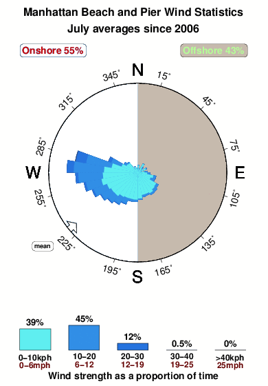


Wind stats for Manhattan Beach and Pier: see the variation in direction and stength by month.
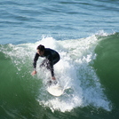
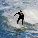
foto dall' album
Contorni: Strade e fiumi: seleziona un surf break dal menu 


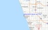
Utilizzare questa mappa sollievo per navigare CAL - LA County surf breaks e stazioni di marea che si trovano nella zona diManhattan Beach and Pier
Altri surf breaks più vicini al Manhattan Beach and Pier:
(clicca sul nome del luogo per maggiori informazioni)- Closest località surf1 mi
- Second closest località surf1 mi
- Third closest località surf1 mi
- Fourth closest località surf1 mi
- Fifth closest località surf2 mi
Onda boe più vicina a Manhattan Beach and Pier:
- Closest Onda boa12 mi
- Second closest Onda boa19 mi
- Third closest Onda boa20 mi
- Fourth closest Onda boa25 mi
- Fifth closest Onda boa36 mi
Stazioni di marea più vicina alla Manhattan Beach and Pier:
- Closest marea stazioneManhattan Beach1 mi
- Second closest marea stazioneEl Segundo, Santa Monica Bay2 mi
- Third closest marea stazioneKing Harbor, Santa Monica Bay3 mi
- Fourth closest marea stazioneMarina del Rey6 mi
- Fifth closest marea stazionePalos Verdes Estates7 mi
Airports
- The closest passenger airport to Manhattan Beach and Pier is Los Angeles International Airport (LAX) in USA, 6 km (4 miles) away (directly).
- The second nearest airport to Manhattan Beach and Pier is Jack Northrop Fld Hawthorne Muni Airport (HHR), also in USA, 9 km (6 miles) away.
- Third is Long Beach Airport (LGB) in USA, 26 km (16 miles) away.
- Burbank Glendale Pasadena Airport (BUR) in USA is 35 km (22 miles) away.
- John Wayne Arpt Orange Co (Santa Ana) Airport (SNA), also in USA is the fifth nearest airport to Manhattan Beach and Pier and is 56 km (35 miles) away.
- /breaks/Manhattan-Beach-Pier/forecasts/latest


 Nearest