
Previsioni:

Previsione a breve terminePioggia abbondante (Totale 25mm), più pesante durante lunedì pomeriggio. Warm (Max 26°C mercoledì pomeriggio, Min 19°C Lunedì notte). Venti decrescenti (raffiche di vento da SSW Lunedì mattina, calma per martedì notte). | |||||||||||||||||||||||
Lunedì 3 | Martedì 4 | Mercoledì 5 | |||||||||||||||||||||
5 AM | 8 AM | 11 AM | 2 PM | 5 PM | 8 PM | 11 PM | 2 AM | 5 AM | 8 AM | 11 AM | 2 PM | 5 PM | 8 PM | 11 PM | 2 AM | 5 AM | 8 AM | 11 AM | 2 PM | 5 PM | 8 PM | 11 PM | |
Mappa dell'altezza del moto ondoso |  |  | 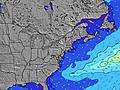 |  | 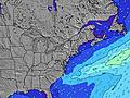 |  |  | 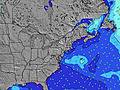 |  | ||||||||||||||
Onda Altezza (m) Direzione Periodo (s) | S 6 | S 7 | S 8 | S 8 | S 9 | S 9 | S 9 | S 9 | S 8 | S 8 | S 8 | S 8 | SSW 8 | SSW 8 | SSW 7 | SSW 7 | SSW 8 | S 8 | S 8 | S 7 | S 7 | S 7 | SSW 7 |
Grafico delle onde | |||||||||||||||||||||||
125 | 415 | 870 | 1034 | 1017 | 963 | 676 | 482 | 356 | 258 | 161 | 144 | 96 | 75 | 73 | 54 | 85 | 130 | 206 | 159 | 103 | 77 | 66 | |
Vento (km/h) | |||||||||||||||||||||||
Stato del vento onshore cross-onshore cross-shore cross-offshore offshore piatto | cross-on | cross-on | cross-on | cross-on | cross-on | cross | cross-off | cross-off | off | glassy | cross | cross-on | cross-on | cross-on | glassy | cross | cross-off | cross-off | off | cross | cross-on | cross-on | cross |
Alta Marea | 11:57AM0.97m | 00:13AM0.87m | 12:46PM0.97m | 1:03AM0.81m | 1:41PM0.98m | ||||||||||||||||||
Basso Marea | 5:09AM0.01m | 5:40PM0.08m | 5:48AM0.02m | 6:32PM0.11m | 6:35AM0.03m | 7:34PM0.14m | |||||||||||||||||
5:41 | — | — | — | — | — | — | — | 5:43 | — | — | — | — | — | — | — | 5:43 | — | — | — | — | — | — | |
— | — | — | — | — | 8:00 | — | — | — | — | — | — | — | 8:00 | — | — | — | — | — | — | 7:59 | — | — | |
mm | 2 | 2 | 2 | 16 | 2 | 3 | — | — | — | — | — | — | — | — | — | — | — | — | — | — | — | — | — |
Temp. °C | 23 | 24 | 24 | 23 | 23 | 24 | 20 | 19 | 19 | 20 | 24 | 25 | 24 | 23 | 23 | 22 | 22 | 22 | 24 | 26 | 25 | 24 | 23 |
Gelo °C | 22 | 23 | 21 | 21 | 21 | 24 | 19 | 19 | 18 | 20 | 24 | 23 | 21 | 22 | 25 | 24 | 24 | 24 | 27 | 26 | 25 | 26 | 26 |
Onda 1 Altezza (m) Direzione Periodo (s) | — | — | — | — | — | — | S 9 | S 9 | S 8 | S 8 | S 8 | S 8 | SSW 8 | SSW 8 | SSW 7 | SSW 7 | SSW 8 | S 8 | S 8 | S 7 | S 7 | S 7 | SE 6 |
— | — | — | — | — | — | 676 | 482 | 356 | 258 | 161 | 144 | 96 | 75 | 73 | 54 | 85 | 130 | 206 | 159 | 103 | 77 | 19 | |
Onda 2 Altezza (m) Direzione Periodo (s) | — | — | — | — | — | — | — | — | — | SE 7 | SE 7 | SE 7 | SSE 7 | SSE 7 | SE 7 | SE 7 | SE 7 | SE 6 | — | N 3 | E 10 | E 10 | E 10 |
— | — | — | — | — | — | — | — | — | 38 | 28 | 37 | 31 | 31 | 37 | 36 | 35 | 40 | — | 1 | 2 | 2 | 2 | |
Onda 3 Altezza (m) Direzione Periodo (s) | — | — | — | — | — | — | — | — | — | — | — | — | — | E 11 | E 12 | — | E 11 | — | — | — | — | — | — |
— | — | — | — | — | — | — | — | — | — | — | — | — | 3 | 3 | — | 2 | — | — | — | — | — | — | |
onde vento Altezza (m) Direzione Periodo (s) | S 6 | S 7 | S 8 | S 8 | S 9 | S 9 | — | NW 3 | NNW 3 | — | — | — | — | — | — | — | SE 6 | NNE 2 | N 3 | — | SW 4 | SSW 4 | SSW 7 |
125 | 415 | 870 | 1034 | 1017 | 963 | — | 1 | 2 | — | — | — | — | — | — | — | 81 | 1 | 1 | — | 14 | 11 | 66 | |
Il più vicino Offshore or Glassy | |||||||||||||||||||||||
Distanza (km) | 1821 | 436 | 418 | 230 | 214 | 5 | 0 | 0 | 0 | 0 | 5 | 19 | 9 | 19 | 1 | 1 | 0 | 0 | 0 | 44 | 19 | 5 | 5 |
Migliori previsioni per le condizioni d'onda in Rhode Island | |||||||||||||||||||||||
Migliori previsioni per le condizioni d'onda in United States | |||||||||||||||||||||||
Trova Onde Globale | |||||||||||||||||||||||
- Map Icons:
 Break
Break Live Wave Height (m)
 Live Wind Speed (km/h)
 Surf Rating (10 Max)
 Ocean Swells (m)
- Wind Speed (km/h)
Widget Free Surf-Forecast.com per il tuo sito
La relazione di surf / widget meteo è disponibile qui sotto per incorporare su siti esterni a titolo gratuito e fornisce una sintesi delle nostre Matunuck previsione surf. Basta prendere il frammento di codice html da noi fornito e copiarlo nel proprio sito. È possibile scegliere la lingua preferita e unità metriche / imperiali per il feed delle previsioni surf per soddisfare le esigenze degli utenti del vostro sito .... Clicca qui per ottenere il codice.
 Nearest