

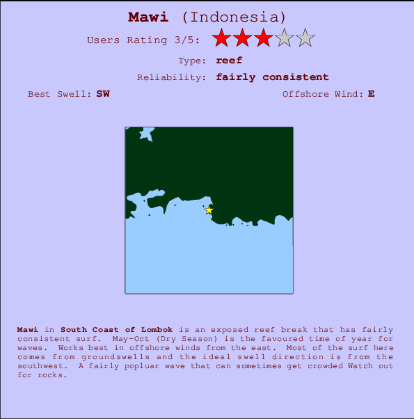
Mawi Surf Guide
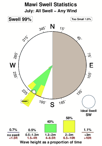
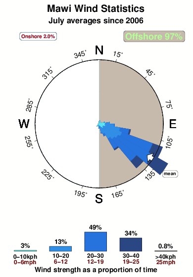
Mawi in South Lombok is an exposed reef break that has fairly consistent surf. May-Oct (Dry Season) is the best time of year for waves. Offshore winds are from the east. Groundswells more frequent than windswells and the ideal swell direction is from the southwest. A left hand reef. When it's working here, it can get crowded. Take care of rocks in the line up.
Mawi Spot Info
| Type: | Rating: | Reliability: | Todays Sea Temp*: |
|---|---|---|---|
| fairly consistent | 27.2°C*ocean temperature recorded from satellite |
Surfing Mawi:
The best conditions reported for surf at Mawi occur when a Southwest swell combines with an offshore wind direction from the East.

Previsioni Energia d'onda (Potenza): 12hrs


Mawi Surf:
Saturday, 18 July 2026, 19:30 Local time| Sabato 18 | Dom | |||
| 5PM | 8PM | 11PM | 2AM | |
| Wave (m) | ||||
| Periodo (s) | 14 | 14 | 14 | 14 |
| Vento (km/h) | ||||
| Stato del vento | cross- off |
cross- off |
cross- off |
cross- off |
- /breaks/Mawi/forecasts/latest
Mawi Surf Guide
Mawi in South Lombok is an exposed reef break that has fairly consistent surf. May-Oct (Dry Season) is the best time of year for waves. Offshore winds are from the east. Groundswells more frequent than windswells and the ideal swell direction is from the southwest. A left hand reef. When it's working here, it can get crowded. Take care of rocks in the line up.
Mawi Spot Info
Type: Rating: Reliability: Todays Sea Temp*:  Reef
Reef 3
3fairly consistent 27.2°C*ocean temperature recorded from satelliteSurfing Mawi:
The best conditions reported for surf at Mawi occur when a Southwest swell combines with an offshore wind direction from the East.
Previsioni Energia d'onda (Potenza): 12hrs
Utilizzare la scheda di navigazione in alto per visualizzare Mawi temperatura del mare, Mawi fotografie, Mawi dettagliate previsioni onde, il vento e le previsioni meteo, Mawi webcam, vento corrente da Lombok - South stazioni meteo e Mawi previsioni marea. Il link Indonesia mappe maree apre l'immagine grande, che mostra Indonesia e dei mari circostanti. Queste mappe possono essere animate per mostrare le diverse componenti del moto ondoso, energia delle onde, periodo d'onda, altezza delle onde, insieme con le previsioni del vento e meteo, meteo corrente e osservazioni sullo stato del mare dal Indonesia onda-boe, le navi passanti e stazioni meteo costiere. Ciascuna delle pagine di previsioni per questo surf break rappresenta uno strumento di wavefinder globale e regionale per individuare le migliori condizioni di surf nella zona intorno Mawi.
Mawi Surf:
Saturday, 18 July 2026, 19:30 Local timeSabato 18 Dom 5PM 8PM 11PM 2AM Wave (m) Periodo (s) 14 14 14 14 Vento (km/h) Stato del vento cross-
offcross-
offcross-
offcross-
off- /breaks/Mawi/forecasts/latest
- /breaks/Mawi/forecasts/latest/six_day
Mawi Surf Guide
Mawi in South Lombok is an exposed reef break that has fairly consistent surf. May-Oct (Dry Season) is the best time of year for waves. Offshore winds are from the east. Groundswells more frequent than windswells and the ideal swell direction is from the southwest. A left hand reef. When it's working here, it can get crowded. Take care of rocks in the line up.
Mawi Spot Info
Type: Rating: Reliability: Todays Sea Temp*: Reef3fairly consistent 27.2°C*ocean temperature recorded from satelliteSurfing Mawi:
The best conditions reported for surf at Mawi occur when a Southwest swell combines with an offshore wind direction from the East.
Previsioni Energia d'onda (Potenza): 12hrs
Utilizzare la scheda di navigazione in alto per visualizzare Mawi temperatura del mare, Mawi fotografie, Mawi dettagliate previsioni onde, il vento e le previsioni meteo, Mawi webcam, vento corrente da Lombok - South stazioni meteo e Mawi previsioni marea. Il link Indonesia mappe maree apre l'immagine grande, che mostra Indonesia e dei mari circostanti. Queste mappe possono essere animate per mostrare le diverse componenti del moto ondoso, energia delle onde, periodo d'onda, altezza delle onde, insieme con le previsioni del vento e meteo, meteo corrente e osservazioni sullo stato del mare dal Indonesia onda-boe, le navi passanti e stazioni meteo costiere. Ciascuna delle pagine di previsioni per questo surf break rappresenta uno strumento di wavefinder globale e regionale per individuare le migliori condizioni di surf nella zona intorno Mawi.
Mawi Surf:
Saturday, 18 July 2026, 19:30 Local timeSabato 18 Dom 5PM 8PM 11PM 2AM Wave (m) Periodo (s) 14 14 14 14 Vento (km/h) Stato del vento cross-
offcross-
offcross-
offcross-
off- /breaks/Mawi/forecasts/latest
Mawi Surf Guide
Mawi in South Lombok is an exposed reef break that has fairly consistent surf. May-Oct (Dry Season) is the best time of year for waves. Offshore winds are from the east. Groundswells more frequent than windswells and the ideal swell direction is from the southwest. A left hand reef. When it's working here, it can get crowded. Take care of rocks in the line up.
Mawi Spot Info
Type: Rating: Reliability: Todays Sea Temp*: Reef3fairly consistent 27.2°C*ocean temperature recorded from satelliteSurfing Mawi:
The best conditions reported for surf at Mawi occur when a Southwest swell combines with an offshore wind direction from the East.
Previsioni Energia d'onda (Potenza): 12hrs
Utilizzare la scheda di navigazione in alto per visualizzare Mawi temperatura del mare, Mawi fotografie, Mawi dettagliate previsioni onde, il vento e le previsioni meteo, Mawi webcam, vento corrente da Lombok - South stazioni meteo e Mawi previsioni marea. Il link Indonesia mappe maree apre l'immagine grande, che mostra Indonesia e dei mari circostanti. Queste mappe possono essere animate per mostrare le diverse componenti del moto ondoso, energia delle onde, periodo d'onda, altezza delle onde, insieme con le previsioni del vento e meteo, meteo corrente e osservazioni sullo stato del mare dal Indonesia onda-boe, le navi passanti e stazioni meteo costiere. Ciascuna delle pagine di previsioni per questo surf break rappresenta uno strumento di wavefinder globale e regionale per individuare le migliori condizioni di surf nella zona intorno Mawi.
Mawi Surf:
Saturday, 18 July 2026, 19:30 Local timeSabato 18 Dom 5PM 8PM 11PM 2AM Wave (m) Periodo (s) 14 14 14 14 Vento (km/h) Stato del vento cross-
offcross-
offcross-
offcross-
offTide Times:
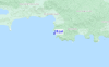
A Mawi (0 km).
PROSSIMA È ALLE (ora locale) rimanente alta marea bassa marea Mawi Tide Times and Tide Chart
Live Weather:
At Bandara Airport, 21 km from Mawi.
light winds from the SSE
(km/h)
Dry and partly cloudyAir temperature
27°COverall Mawi Surf Consistency and Wind Distribution in Luglio
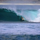
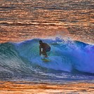
foto dall' album
Contorni: Strade e fiumi: seleziona un surf break dal menu 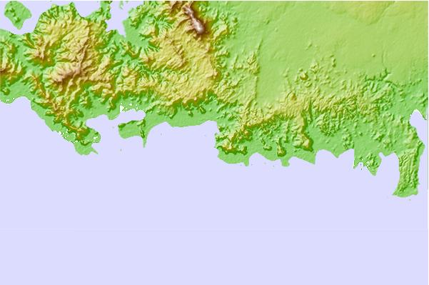
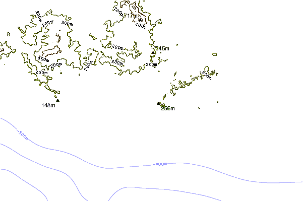
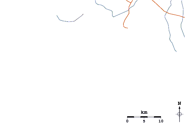
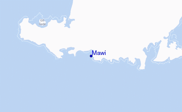
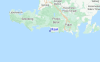
Utilizzare questa mappa sollievo per navigare Lombok - South surf breaks e stazioni di marea che si trovano nella zona diMawi
Altri surf breaks più vicini al Mawi:
(clicca sul nome del luogo per maggiori informazioni)- Closest località surf2 mi
- Second closest località surf3 mi
- Third closest località surf6 mi
- Fourth closest località surf9 mi
- Fifth closest località surf9 mi
Onda boe più vicina a Mawi:
- Closest Onda boa1752 mi
- Second closest Onda boa2062 mi
- Third closest Onda boa2186 mi
- Fourth closest Onda boa2264 mi
- Fifth closest Onda boa2277 mi
Stazioni di marea più vicina alla Mawi:
- Closest marea stazioneMataram21 mi
- Second closest marea stazioneDenpasar67 mi
- Third closest marea stazioneSingaraja90 mi
- Fourth closest marea stazioneSumbawa Besar91 mi
- Fifth closest marea stazioneBanjar95 mi
Airports
- The closest passenger airport to Mawi is Selaparang (Mataram) Airport (AMI) in Indonesia, which is 38 km (24 miles) away (directly).
- The second nearest airport to Mawi is Bali International (Denpasar) Airport (DPS), also in Indonesia, 110 km (68 miles) away.
- The third closest airport is Sumbawa Besar Airport (SWG), also in Indonesia, 145 km (90 miles) away.
- /breaks/Mawi/forecasts/latest


 Nearest