
Previsioni:

Previsione a breve termineper lo più asciutto. Warm (Max 21°C Sabato mattina, Min 20°C Venerdì notte). Principalmente venti freschi. | ||||||||||||||||||||||||
Sabato 18 | Domenica 19 | Lunedì 20 | ||||||||||||||||||||||
1 AM | 4 AM | 7 AM | 10 AM | 1 PM | 4 PM | 7 PM | 10 PM | 1 AM | 4 AM | 7 AM | 10 AM | 1 PM | 4 PM | 7 PM | 10 PM | 1 AM | 4 AM | 7 AM | 10 AM | 1 PM | 4 PM | 7 PM | 10 PM | |
Mappa dell'altezza del moto ondoso |  | 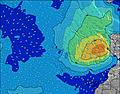 |  |  | 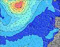 |  |  | 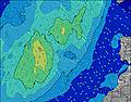 | 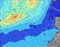 | |||||||||||||||
Onda Altezza (m) Direzione Periodo (s) | NNE 5 | NNE 5 | NNE 6 | NNE 6 | NNE 6 | N 6 | NNE 6 | NNE 6 | NNE 6 | NNE 6 | NNE 6 | NNE 6 | NNE 7 | NNE 7 | NNE 6 | NNE 6 | NNE 6 | NNE 6 | NNE 7 | N 7 | N 7 | N 7 | N 6 | N 6 |
Grafico delle onde | ||||||||||||||||||||||||
74 | 78 | 94 | 101 | 86 | 88 | 95 | 108 | 108 | 126 | 134 | 127 | 152 | 152 | 139 | 170 | 188 | 200 | 206 | 226 | 233 | 218 | 157 | 178 | |
Vento (km/h) | ||||||||||||||||||||||||
Stato del vento onshore cross-onshore cross-shore cross-offshore offshore piatto | cross-on | cross-on | on | on | on | on | on | on | on | cross-on | on | on | on | on | on | on | cross-on | on | on | on | on | on | on | on |
Alta Marea | 5:04AM2.18m | 5:19PM2.41m | 5:48AM2.06m | 6:04PM2.23m | 6:34AM1.94m | 6:52PM2.02m | ||||||||||||||||||
Basso Marea | 10:54PM0.08m | 10:58AM0.27m | 11:37PM0.23m | 11:42AM0.40m | 00:21AM0.39m | 12:29PM0.55m | ||||||||||||||||||
— | — | 7:07 | — | — | — | — | — | — | — | 7:09 | — | — | — | — | — | — | — | 7:09 | — | — | — | — | — | |
— | — | — | — | — | — | 8:53 | — | — | — | — | — | — | — | 8:53 | — | — | — | — | — | — | — | 8:52 | — | |
mm | — | — | — | — | — | — | — | — | — | — | — | — | — | — | — | — | — | — | — | — | — | — | — | — |
Temp. °C | 20 | 20 | 20 | 20 | 21 | 21 | 21 | 20 | 20 | 20 | 20 | 20 | 21 | 21 | 21 | 21 | 20 | 20 | 20 | 21 | 21 | 21 | 21 | 21 |
Gelo °C | 18 | 18 | 18 | 18 | 19 | 19 | 19 | 18 | 18 | 18 | 18 | 17 | 18 | 18 | 18 | 19 | 17 | 17 | 17 | 18 | 18 | 18 | 18 | 19 |
Onda 1 Altezza (m) Direzione Periodo (s) | WNW 8 | WNW 8 | WNW 8 | WNW 7 | WNW 7 | WNW 8 | WNW 8 | WNW 8 | WNW 8 | WNW 10 | WNW 9 | WNW 9 | WNW 9 | WNW 9 | WNW 8 | WNW 8 | WNW 8 | NW 8 | NW 8 | WNW 8 | NW 8 | NW 8 | NE 8 | NW 8 |
13 | 12 | 11 | 5 | 5 | 6 | 6 | 6 | 6 | 18 | 17 | 16 | 16 | 16 | 14 | 14 | 13 | 17 | 17 | 13 | 16 | 15 | 54 | 14 | |
Onda 2 Altezza (m) Direzione Periodo (s) | — | — | — | NW 9 | W 11 | W 11 | W 11 | NW 10 | WNW 10 | — | — | S 16 | S 16 | S 16 | S 16 | — | — | N 11 | N 11 | S 14 | S 14 | N 10 | NW 8 | N 9 |
— | — | — | 3 | 3 | 2 | 2 | 4 | 10 | — | — | 5 | 5 | 5 | 5 | — | — | 2 | 2 | 4 | 4 | 2 | 15 | 2 | |
Onda 3 Altezza (m) Direzione Periodo (s) | — | — | — | W 9 | S 18 | S 18 | — | — | — | — | — | — | — | — | — | — | — | — | S 14 | — | — | W 13 | NW 13 | NW 13 |
— | — | — | 2 | 6 | 6 | — | — | — | — | — | — | — | — | — | — | — | — | 4 | — | — | 3 | 7 | 6 | |
onde vento Altezza (m) Direzione Periodo (s) | NNE 5 | NNE 5 | NNE 6 | NNE 6 | NNE 6 | N 6 | NNE 6 | NNE 6 | NNE 6 | NNE 6 | NNE 6 | NNE 6 | NNE 7 | NNE 7 | NNE 6 | NNE 6 | NNE 6 | NNE 6 | NNE 7 | N 7 | N 7 | N 7 | N 6 | N 6 |
74 | 78 | 94 | 101 | 86 | 88 | 95 | 108 | 108 | 126 | 134 | 127 | 152 | 152 | 139 | 170 | 188 | 200 | 206 | 226 | 233 | 218 | 157 | 178 | |
Il più vicino Offshore or Glassy | ||||||||||||||||||||||||
Distanza (km) | 291 | 284 | 205 | 205 | 179 | 179 | 205 | 205 | 205 | 205 | 205 | 205 | 205 | 284 | 285 | 285 | 285 | 285 | 205 | 205 | 285 | 284 | 205 | 284 |
Migliori previsioni per le condizioni d'onda in Fuerteventura | ||||||||||||||||||||||||
Migliori previsioni per le condizioni d'onda in Spain (Africa) | ||||||||||||||||||||||||
Trova Onde Globale | ||||||||||||||||||||||||
- Map Icons:
 Break
Break Live Wave Height (m)
 Live Wind Speed (km/h)
 Surf Rating (10 Max)
 Ocean Swells (m)
- Wind Speed (km/h)
Widget Free Surf-Forecast.com per il tuo sito
La relazione di surf / widget meteo è disponibile qui sotto per incorporare su siti esterni a titolo gratuito e fornisce una sintesi delle nostre Mechihonas previsione surf. Basta prendere il frammento di codice html da noi fornito e copiarlo nel proprio sito. È possibile scegliere la lingua preferita e unità metriche / imperiali per il feed delle previsioni surf per soddisfare le esigenze degli utenti del vostro sito .... Clicca qui per ottenere il codice.
 Nearest