
Previsioni:

Previsione a breve terminepioggia leggera (Totale 3mm), per lo più che cade Venerdì notte. Warm (Max 26°C Venerdì notte, Min 17°C Sabato notte). Vento sarà generalmente leggero. | ||||||||||||||||||||||
Giovedì 16 | Venerdì 17 | Sabato 18 | ||||||||||||||||||||
6 AM | 9 AM | 12 PM | 3 PM | 6 PM | 9 PM | 12 AM | 3 AM | 6 AM | 9 AM | 12 PM | 3 PM | 6 PM | 9 PM | 12 AM | 3 AM | 6 AM | 9 AM | 12 PM | 3 PM | 6 PM | 9 PM | |
Mappa dell'altezza del moto ondoso | 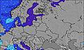 | 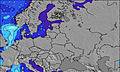 | 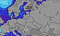 | 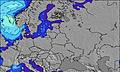 | 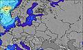 | 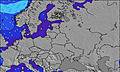 | 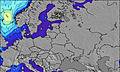 | 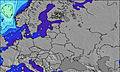 | ||||||||||||||
Onda Altezza (m) Direzione Periodo (s) | NNW 3 | — | — | NNW 2 | NW 3 | NNW 4 | NW 4 | NNW 4 | NNW 4 | — | — | — | — | — | — | SE 2 | SSE 3 | S 4 | SSW 5 | SW 6 | WSW 5 | WSW 6 |
Grafico delle onde | ||||||||||||||||||||||
1 | 0 | 0 | 1 | 2 | 5 | 3 | 1 | 1 | 0 | 0 | 0 | 0 | 0 | 0 | 0 | 0 | 0 | 73 | 131 | 78 | 101 | |
Vento (km/h) | ||||||||||||||||||||||
Stato del vento onshore cross-onshore cross-shore cross-offshore offshore piatto | cross | cross | cross-on | cross-on | cross-on | on | cross-off | cross-off | cross-off | cross-off | cross | cross-on | glassy | cross-off | off | off | cross-off | cross-off | cross | cross-on | cross-on | cross-on |
Alta Marea | 1:36PM0.03m | 4:19AM0.03m | 2:30PM0.03m | 4:46AM0.03m | 3:28PM0.03m | |||||||||||||||||
Basso Marea | 8:49AM0.02m | 8:55PM0.00m | 9:38AM0.02m | 9:32PM0.01m | 10:39AM0.02m | |||||||||||||||||
5:11 | — | — | — | — | — | — | 5:13 | — | — | — | — | — | — | — | 5:15 | — | — | — | — | — | — | |
— | — | — | — | — | 10:08 | — | — | — | — | — | — | — | 10:07 | — | — | — | — | — | — | — | 10:06 | |
mm | — | — | — | — | — | — | — | — | — | — | — | — | — | — | — | — | 1 | 1 | 1 | — | — | — |
Temp. °C | 18 | 19 | 22 | 22 | 23 | 24 | 24 | 21 | 20 | 19 | 21 | 23 | 25 | 26 | 24 | 21 | 18 | 18 | 18 | 18 | 18 | 17 |
Gelo °C | 16 | 17 | 20 | 20 | 20 | 21 | 24 | 19 | 18 | 18 | 20 | 23 | 26 | 25 | 23 | 18 | 17 | 16 | 16 | 16 | 16 | 16 |
Onda 1 Altezza (m) Direzione Periodo (s) | NNW 3 | — | — | — | — | — | NW 4 | NNW 4 | NNW 4 | — | — | — | — | — | — | — | — | — | — | — | — | — |
1 | — | — | — | — | — | 3 | 1 | 1 | — | — | — | — | — | — | — | — | — | — | — | — | — | |
Onda 2 Altezza (m) Direzione Periodo (s) | — | — | — | — | — | — | — | — | — | — | — | — | — | — | — | — | — | — | — | — | — | — |
— | — | — | — | — | — | — | — | — | — | — | — | — | — | — | — | — | — | — | — | — | — | |
Onda 3 Altezza (m) Direzione Periodo (s) | — | — | — | — | — | — | — | — | — | — | — | — | — | — | — | — | — | — | — | — | — | — |
— | — | — | — | — | — | — | — | — | — | — | — | — | — | — | — | — | — | — | — | — | — | |
onde vento Altezza (m) Direzione Periodo (s) | — | — | — | NNW 2 | NW 3 | NNW 4 | — | — | — | — | — | — | — | — | — | SE 2 | SSE 3 | S 4 | SSW 5 | SW 6 | WSW 5 | WSW 6 |
— | — | — | 1 | 2 | 5 | — | — | — | — | — | — | — | — | — | 1 | 3 | 23 | 73 | 131 | 78 | 101 | |
Il più vicino Offshore or Glassy | ||||||||||||||||||||||
Distanza (km) | 1124 | 1124 | 1696 | 1500 | 1499 | 1124 | 1449 | 1449 | 1449 | 1124 | 1601 | 1579 | 1726 | 1420 | 1418 | 1124 | 908 | 1418 | 1418 | 170 | 279 | |
Migliori previsioni per le condizioni d'onda in Baltic | ||||||||||||||||||||||
Migliori previsioni per le condizioni d'onda in Lithuania | ||||||||||||||||||||||
Trova Onde Globale | ||||||||||||||||||||||
- Map Icons:
 Break
Break Live Wave Height (m)
 Live Wind Speed (km/h)
 Surf Rating (10 Max)
 Ocean Swells (m)
- Wind Speed (km/h)
Widget Free Surf-Forecast.com per il tuo sito
La relazione di surf / widget meteo è disponibile qui sotto per incorporare su siti esterni a titolo gratuito e fornisce una sintesi delle nostre Melnrage previsione surf. Basta prendere il frammento di codice html da noi fornito e copiarlo nel proprio sito. È possibile scegliere la lingua preferita e unità metriche / imperiali per il feed delle previsioni surf per soddisfare le esigenze degli utenti del vostro sito .... Clicca qui per ottenere il codice.
 Nearest