
Previsioni:

Previsione a breve termineper lo più asciutto. Warm (Max 28°C giovedì mattina, Min 22°C Lunedì notte). Principalmente venti freschi. | ||||||||||||||||||
Lun 3 | Martedì 4 | Mercoledì 5 | ||||||||||||||||
6 PM | 9 PM | 12 AM | 3 AM | 6 AM | 9 AM | 12 PM | 3 PM | 6 PM | 9 PM | 12 AM | 3 AM | 6 AM | 9 AM | 12 PM | 3 PM | 6 PM | 9 PM | |
Mappa dell'altezza del moto ondoso |  |  | 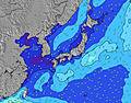 |  |  | 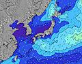 |  | |||||||||||
Onda Altezza (m) Direzione Periodo (s) | SE 16 | SE 17 | SE 17 | SE 16 | SE 17 | ESE 16 | ESE 16 | ESE 16 | SE 16 | SE 16 | SE 16 | SE 15 | SE 15 | SE 16 | SE 16 | SE 16 | SSE 15 | SSE 15 |
Grafico delle onde | ||||||||||||||||||
3512 | 4095 | 4420 | 3761 | 5672 | 7039 | 7474 | 7584 | 8478 | 8967 | 9052 | 8654 | 8831 | 9407 | 9324 | 8715 | 7635 | 5939 | |
Vento (km/h) | ||||||||||||||||||
Stato del vento onshore cross-onshore cross-shore cross-offshore offshore piatto | off | off | off | off | off | off | off | off | off | off | off | off | off | off | off | off | off | off |
Alta Marea | 7:33PM1.45m | 7:34AM1.34m | 7:55PM1.45m | 8:34AM1.24m | 8:19PM1.44m | |||||||||||||
Basso Marea | 1:41AM0.57m | 1:38PM0.56m | 2:28AM0.52m | 2:08PM0.74m | ||||||||||||||
— | — | — | 4:50 | — | — | — | — | — | — | — | 4:52 | — | — | — | — | — | — | |
6:42 | — | — | — | — | — | — | — | 6:40 | — | — | — | — | — | — | — | 6:39 | — | |
mm | — | — | — | — | — | — | — | — | — | — | — | — | — | — | — | — | — | — |
Temp. °C | 25 | 24 | 23 | 22 | 23 | 24 | 25 | 26 | 24 | 23 | 23 | 23 | 23 | 24 | 26 | 27 | 27 | 26 |
Gelo °C | 23 | 21 | 20 | 19 | 19 | 20 | 22 | 23 | 21 | 20 | 20 | 20 | 20 | 21 | 25 | 27 | 28 | 28 |
Onda 1 Altezza (m) Direzione Periodo (s) | SE 16 | SE 17 | SE 17 | SE 16 | SE 17 | ESE 16 | ESE 16 | ESE 16 | SE 16 | SE 16 | SE 16 | SE 15 | SE 15 | SE 16 | SE 16 | SE 16 | SSE 15 | SSE 15 |
3512 | 4095 | 4420 | 3761 | 5672 | 7039 | 7474 | 7584 | 8478 | 8967 | 9052 | 8654 | 8831 | 9407 | 9324 | 8715 | 7635 | 5939 | |
Onda 2 Altezza (m) Direzione Periodo (s) | E 14 | E 14 | ENE 14 | SE 20 | ENE 14 | ENE 14 | E 13 | ENE 13 | ENE 13 | ENE 13 | ENE 13 | ENE 13 | ENE 13 | — | ENE 18 | — | ENE 18 | ENE 18 |
100 | 98 | 63 | 1233 | 62 | 63 | 92 | 58 | 58 | 57 | 57 | 57 | 55 | — | 31 | — | 30 | 30 | |
Onda 3 Altezza (m) Direzione Periodo (s) | — | — | — | ENE 14 | — | — | — | — | — | — | — | — | — | — | — | — | — | — |
— | — | — | 63 | — | — | — | — | — | — | — | — | — | — | — | — | — | — | |
onde vento Altezza (m) Direzione Periodo (s) | ENE 6 | ENE 7 | ENE 7 | ENE 7 | ENE 8 | ENE 8 | ENE 8 | ENE 8 | ENE 7 | ENE 7 | ENE 7 | — | — | — | — | — | — | E 11 |
175 | 230 | 314 | 294 | 327 | 532 | 575 | 452 | 456 | 508 | 403 | — | — | — | — | — | — | 599 | |
Il più vicino Offshore or Glassy | ||||||||||||||||||
Distanza (km) | 153 | 153 | 501 | 153 | 153 | 504 | 153 | 14 | 504 | 504 | 504 | 501 | 501 | 501 | 501 | 14 | 14 | 0 |
Migliori previsioni per le condizioni d'onda in Chiba | ||||||||||||||||||
Migliori previsioni per le condizioni d'onda in Japan | ||||||||||||||||||
Trova Onde Globale | ||||||||||||||||||
- Map Icons:
 Break
Break Live Wave Height (m)
 Live Wind Speed (km/h)
 Surf Rating (10 Max)
 Ocean Swells (m)
- Wind Speed (km/h)
Widget Free Surf-Forecast.com per il tuo sito
La relazione di surf / widget meteo è disponibile qui sotto per incorporare su siti esterni a titolo gratuito e fornisce una sintesi delle nostre Mera previsione surf. Basta prendere il frammento di codice html da noi fornito e copiarlo nel proprio sito. È possibile scegliere la lingua preferita e unità metriche / imperiali per il feed delle previsioni surf per soddisfare le esigenze degli utenti del vostro sito .... Clicca qui per ottenere il codice.
 Nearest