
Previsioni:

Previsione a breve termineper lo più asciutto. Warm (Max 26°C Domenica mattina, Min 22°C Domenica mattina). Vento sarà generalmente leggero. | ||||||||||||||||||||||||
Sabato 18 | Domenica 19 | Lunedì 20 | ||||||||||||||||||||||
12 AM | 3 AM | 6 AM | 9 AM | 12 PM | 3 PM | 6 PM | 9 PM | 12 AM | 3 AM | 6 AM | 9 AM | 12 PM | 3 PM | 6 PM | 9 PM | 12 AM | 3 AM | 6 AM | 9 AM | 12 PM | 3 PM | 6 PM | 9 PM | |
Mappa dell'altezza del moto ondoso | 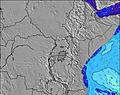 | 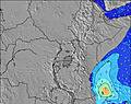 | 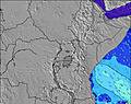 | 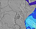 | 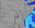 | 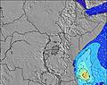 | 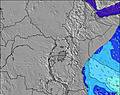 | 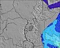 | 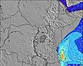 | |||||||||||||||
Onda Altezza (m) Direzione Periodo (s) | SE 7 | SSE 7 | ESE 9 | ESE 9 | ESE 9 | ESE 9 | ESE 9 | ESE 9 | ESE 9 | ESE 9 | SSE 7 | ESE 9 | ESE 9 | ESE 9 | ESE 9 | ESE 9 | ESE 9 | ESE 9 | ESE 9 | ESE 9 | ESE 9 | ESE 9 | SE 9 | SE 9 |
Grafico delle onde | ||||||||||||||||||||||||
178 | 222 | 94 | 149 | 161 | 161 | 158 | 158 | 132 | 120 | 119 | 154 | 154 | 154 | 143 | 146 | 119 | 133 | 133 | 133 | 158 | 154 | 202 | 202 | |
Vento (km/h) | ||||||||||||||||||||||||
Stato del vento onshore cross-onshore cross-shore cross-offshore offshore piatto | cross | cross | cross-off | cross | cross | cross | cross | cross-on | cross-on | cross | cross | cross | cross | cross | cross-on | cross-on | cross | cross | cross-off | cross-off | cross-on | cross-on | cross-on | cross-on |
Alta Marea | 6:54AM3.28m | 7:05PM3.35m | 7:35AM3.21m | 7:44PM3.07m | 8:17AM3.09m | 8:24PM2.77m | ||||||||||||||||||
Basso Marea | 00:39AM0.18m | 12:51PM0.47m | 1:15AM0.32m | 1:36PM0.64m | 1:52AM0.50m | 2:22PM0.85m | ||||||||||||||||||
— | — | 6:30 | — | — | — | — | — | — | — | 6:30 | — | — | — | — | — | — | — | 6:30 | — | — | — | — | — | |
— | — | — | — | — | — | 6:23 | — | — | — | — | — | — | — | 6:23 | — | — | — | — | — | — | — | 6:24 | — | |
mm | — | — | — | — | — | — | — | — | — | — | — | — | — | — | — | — | — | — | — | — | — | — | — | — |
Temp. °C | 24 | 23 | 23 | 24 | 25 | 25 | 25 | 24 | 24 | 24 | 23 | 25 | 26 | 26 | 25 | 24 | 24 | 23 | 22 | 24 | 26 | 26 | 25 | 24 |
Gelo °C | 23 | 23 | 23 | 23 | 23 | 23 | 25 | 23 | 24 | 25 | 23 | 25 | 25 | 24 | 24 | 24 | 24 | 23 | 23 | 25 | 25 | 25 | 25 | 24 |
Onda 1 Altezza (m) Direzione Periodo (s) | ESE 9 | SE 7 | ESE 7 | ESE 9 | ESE 9 | ESE 9 | ESE 9 | ESE 9 | ESE 9 | ESE 9 | ESE 9 | ESE 9 | ESE 9 | ESE 9 | ESE 9 | ESE 9 | ESE 9 | ESE 9 | ESE 9 | ESE 9 | ESE 9 | ESE 9 | S 9 | S 9 |
98 | 163 | 78 | 149 | 161 | 161 | 158 | 158 | 119 | 119 | 119 | 154 | 154 | 154 | 143 | 146 | 119 | 133 | 133 | 133 | 158 | 154 | 2 | 2 | |
Onda 2 Altezza (m) Direzione Periodo (s) | S 10 | ESE 9 | ESE 9 | — | — | — | — | S 16 | S 16 | S 16 | S 15 | — | — | S 11 | S 13 | S 13 | S 13 | S 12 | S 10 | S 10 | S 10 | S 9 | E 17 | E 16 |
2 | 98 | 94 | — | — | — | — | 5 | 5 | 5 | 4 | — | — | 2 | 3 | 3 | 3 | 3 | 2 | 2 | 2 | 2 | 6 | 5 | |
Onda 3 Altezza (m) Direzione Periodo (s) | — | S 10 | — | — | — | — | — | — | — | — | — | — | — | S 14 | S 14 | S 10 | S 10 | — | — | S 12 | E 18 | E 17 | E 17 | E 16 |
— | 2 | — | — | — | — | — | — | — | — | — | — | — | 4 | 4 | 2 | 2 | — | — | 3 | 6 | 6 | 5 | 5 | |
onde vento Altezza (m) Direzione Periodo (s) | SE 7 | SSE 7 | S 7 | SSE 7 | SSE 7 | SSE 7 | SSE 7 | SSE 7 | SSE 6 | SE 6 | SSE 7 | SSE 7 | SSE 6 | SSE 6 | SSE 6 | SSE 6 | SSE 6 | S 6 | S 6 | S 6 | S 6 | S 6 | SE 9 | SE 9 |
178 | 222 | 86 | 108 | 102 | 121 | 102 | 111 | 132 | 120 | 116 | 75 | 56 | 60 | 55 | 51 | 41 | 36 | 24 | 17 | 17 | 24 | 202 | 202 | |
Il più vicino Offshore or Glassy | ||||||||||||||||||||||||
Distanza (km) | 2205 | 2205 | 187 | 187 | 187 | 187 | 2453 | 2439 | 2163 | 296 | 296 | 2184 | 187 | 187 | 2457 | 2213 | 2184 | 187 | 0 | 187 | 187 | 187 | 2237 | 2237 |
Migliori previsioni per le condizioni d'onda in Kenya | ||||||||||||||||||||||||
Migliori previsioni per le condizioni d'onda in Kenya | ||||||||||||||||||||||||
Trova Onde Globale | ||||||||||||||||||||||||
- Map Icons:
 Break
Break Live Wave Height (m)
 Live Wind Speed (km/h)
 Surf Rating (10 Max)
 Ocean Swells (m)
- Wind Speed (km/h)
Widget Free Surf-Forecast.com per il tuo sito
La relazione di surf / widget meteo è disponibile qui sotto per incorporare su siti esterni a titolo gratuito e fornisce una sintesi delle nostre Mombasa Channel previsione surf. Basta prendere il frammento di codice html da noi fornito e copiarlo nel proprio sito. È possibile scegliere la lingua preferita e unità metriche / imperiali per il feed delle previsioni surf per soddisfare le esigenze degli utenti del vostro sito .... Clicca qui per ottenere il codice.
 Nearest