
Previsioni:

Previsione a breve termineper lo più asciutto. Warm (Max 20°C Sabato pomeriggio, Min 14°C Domenica mattina). Vento sarà generalmente leggero. | ||||||||||||||||||||||||
Sabato 18 | Domenica 19 | Lunedì 20 | ||||||||||||||||||||||
2 AM | 5 AM | 8 AM | 11 AM | 2 PM | 5 PM | 8 PM | 11 PM | 2 AM | 5 AM | 8 AM | 11 AM | 2 PM | 5 PM | 8 PM | 11 PM | 2 AM | 5 AM | 8 AM | 11 AM | 2 PM | 5 PM | 8 PM | 11 PM | |
Mappa dell'altezza del moto ondoso |  | 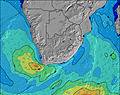 |  |  |  |  |  |  |  | |||||||||||||||
Onda Altezza (m) Direzione Periodo (s) | SSW 11 | SSW 10 | SSW 11 | S 12 | S 12 | S 12 | S 11 | S 11 | S 11 | S 11 | S 11 | SE 13 | SE 10 | SSE 11 | SE 12 | SE 12 | SE 12 | SE 12 | SW 9 | SE 12 | SE 12 | SE 12 | SE 12 | SE 12 |
Grafico delle onde | ||||||||||||||||||||||||
340 | 251 | 225 | 368 | 485 | 535 | 474 | 434 | 517 | 525 | 272 | 424 | 486 | 610 | 710 | 594 | 736 | 748 | 1024 | 700 | 689 | 689 | 625 | 625 | |
Vento (km/h) | ||||||||||||||||||||||||
Stato del vento onshore cross-onshore cross-shore cross-offshore offshore piatto | off | off | off | cross | cross-on | cross-on | cross-off | cross-off | off | off | off | glassy | cross-on | cross-on | cross-off | cross-off | cross-off | cross-off | cross-off | glassy | on | cross-on | cross-off | cross-off |
Alta Marea | 6:11AM1.48m | 6:41PM1.58m | 6:47AM1.38m | 7:18PM1.48m | 7:24AM1.26m | 7:57PM1.36m | ||||||||||||||||||
Basso Marea | 00:11AM0.18m | 12:18PM0.10m | 00:50AM0.27m | 12:53PM0.20m | 1:29AM0.37m | 1:29PM0.32m | ||||||||||||||||||
— | 7:05 | — | — | — | — | — | — | — | 7:05 | — | — | — | — | — | — | — | 7:03 | — | — | — | — | — | — | |
— | — | — | — | — | 5:20 | — | — | — | — | — | — | — | 5:20 | — | — | — | — | — | — | — | 5:21 | — | — | |
mm | — | — | — | — | — | — | — | — | — | — | — | — | — | — | — | — | — | — | — | — | — | — | — | — |
Temp. °C | 15 | 15 | 15 | 19 | 20 | 19 | 18 | 17 | 16 | 16 | 16 | 19 | 20 | 18 | 17 | 16 | 15 | 14 | 14 | 18 | 18 | 18 | 16 | 16 |
Gelo °C | 15 | 14 | 13 | 17 | 18 | 18 | 17 | 16 | 14 | 14 | 14 | 18 | 18 | 17 | 16 | 14 | 12 | 11 | 12 | 17 | 16 | 16 | 13 | 14 |
Onda 1 Altezza (m) Direzione Periodo (s) | SSW 11 | SSW 10 | SSW 11 | S 12 | S 12 | S 12 | S 11 | S 11 | S 11 | S 11 | S 11 | SE 13 | SE 10 | SSE 11 | SE 12 | SE 12 | SE 12 | SE 12 | SE 12 | SE 12 | SE 12 | SE 12 | SE 12 | SE 12 |
340 | 251 | 218 | 368 | 485 | 535 | 474 | 434 | 517 | 525 | 272 | 424 | 486 | 610 | 710 | 594 | 736 | 748 | 700 | 700 | 689 | 689 | 625 | 625 | |
Onda 2 Altezza (m) Direzione Periodo (s) | E 10 | E 10 | S 13 | E 10 | E 10 | E 10 | E 10 | E 10 | E 10 | SSE 10 | SSW 10 | S 11 | SSW 9 | SW 9 | S 10 | SE 14 | E 10 | SSW 9 | SSW 9 | SSW 9 | SSW 13 | SSW 12 | SSW 12 | SSW 12 |
127 | 127 | 225 | 127 | 125 | 98 | 98 | 96 | 96 | 97 | 208 | 267 | 103 | 79 | 71 | 218 | 56 | 320 | 395 | 255 | 451 | 309 | 255 | 180 | |
Onda 3 Altezza (m) Direzione Periodo (s) | S 15 | S 14 | E 10 | SW 11 | SW 11 | SW 10 | SW 10 | SE 11 | SE 11 | E 10 | SE 13 | SW 9 | S 10 | E 10 | E 10 | S 10 | S 10 | E 10 | ENE 10 | SSW 13 | ENE 10 | ENE 10 | E 10 | E 10 |
69 | 132 | 127 | 119 | 73 | 35 | 15 | 33 | 61 | 71 | 215 | 128 | 138 | 49 | 51 | 48 | 47 | 53 | 34 | 69 | 33 | 33 | 31 | 17 | |
onde vento Altezza (m) Direzione Periodo (s) | — | — | — | — | — | — | SW 10 | SW 10 | — | — | — | — | — | — | — | SW 8 | SW 12 | SW 9 | SW 9 | — | — | — | — | NE 3 |
— | — | — | — | — | — | 217 | 245 | — | — | — | — | — | — | — | 177 | 232 | 649 | 1024 | — | — | — | — | 3 | |
Il più vicino Offshore or Glassy | ||||||||||||||||||||||||
Distanza (km) | 0 | 0 | 0 | 3 | 3 | 3 | 0 | 0 | 0 | 0 | 0 | 0 | 3 | 3 | 0 | 0 | 4 | 0 | 0 | 0 | 3 | 287 | 2 | 15 |
Migliori previsioni per le condizioni d'onda in Eastern Cape - Wild Coast | ||||||||||||||||||||||||
Migliori previsioni per le condizioni d'onda in South Africa | ||||||||||||||||||||||||
Trova Onde Globale | ||||||||||||||||||||||||
- Map Icons:
 Break
Break Live Wave Height (m)
 Live Wind Speed (km/h)
 Surf Rating (10 Max)
 Ocean Swells (m)
- Wind Speed (km/h)
Widget Free Surf-Forecast.com per il tuo sito
La relazione di surf / widget meteo è disponibile qui sotto per incorporare su siti esterni a titolo gratuito e fornisce una sintesi delle nostre Morgans Bay previsione surf. Basta prendere il frammento di codice html da noi fornito e copiarlo nel proprio sito. È possibile scegliere la lingua preferita e unità metriche / imperiali per il feed delle previsioni surf per soddisfare le esigenze degli utenti del vostro sito .... Clicca qui per ottenere il codice.
 Nearest