
Previsioni:

Aggiornamento in hr min s Forecast update imminent
Previsione a breve termineper lo più asciutto. Warm (Max 23°C giovedì notte, Min 22°C Venerdì notte). Principalmente venti freschi. | ||||||||||||||||||||||||
Gio 25 | Venerdì 26 | Sabato 27 | Domenica 28 | |||||||||||||||||||||
7 PM | 10 PM | 1 AM | 4 AM | 7 AM | 10 AM | 1 PM | 4 PM | 7 PM | 10 PM | 1 AM | 4 AM | 7 AM | 10 AM | 1 PM | 4 PM | 7 PM | 10 PM | 1 AM | 4 AM | 7 AM | 10 AM | 1 PM | 4 PM | |
Mappa dell'altezza del moto ondoso |  | 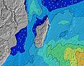 | 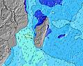 | 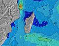 | 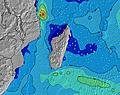 | 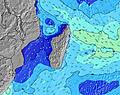 | 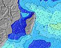 | 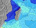 | 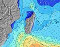 | |||||||||||||||
Onda Altezza (m) Direzione Periodo (s) | SSW 15 | SSW 15 | SSW 15 | SSW 15 | SSW 14 | SSW 14 | SSW 14 | SSW 14 | SSW 14 | SSW 13 | SSW 13 | SSW 13 | SSW 13 | SW 18 | SW 17 | SW 17 | SW 17 | SW 16 | SW 16 | SW 16 | SW 16 | SW 16 | SW 15 | SW 14 |
Grafico delle onde | ||||||||||||||||||||||||
1735 | 1578 | 1393 | 1145 | 996 | 969 | 826 | 700 | 607 | 553 | 472 | 465 | 457 | 595 | 760 | 1282 | 1399 | 1287 | 1096 | 1096 | 1082 | 967 | 753 | 668 | |
Vento (km/h) | ||||||||||||||||||||||||
Stato del vento onshore cross-onshore cross-shore cross-offshore offshore piatto | cross-off | cross-off | cross-off | cross-off | cross-off | cross-off | cross-off | cross-off | cross-off | cross-off | cross-off | cross-off | cross-off | cross-off | cross-off | cross-off | cross-off | cross-off | cross-off | cross-off | cross-off | cross-off | cross-off | cross-off |
Alta Marea | 10:11PM0.56m | 11:29AM0.49m | 10:48PM0.58m | 12:01PM0.51m | 11:23PM0.61m | 12:29PM0.53m | ||||||||||||||||||
Basso Marea | 5:01AM0.18m | 4:46PM0.29m | 5:35AM0.14m | 5:25PM0.27m | 6:08AM0.10m | |||||||||||||||||||
— | — | — | 6:46 | — | — | — | — | — | — | — | 6:46 | — | — | — | — | — | — | — | 6:47 | — | — | — | — | |
— | — | — | — | — | — | — | 5:39 | — | — | — | — | — | — | — | 5:39 | — | — | — | — | — | — | — | 5:39 | |
mm | 1 | — | — | — | — | — | — | — | — | — | — | — | — | — | — | — | — | — | — | — | — | — | — | — |
Temp. °C | 23 | 23 | 23 | 23 | 23 | 23 | 23 | 23 | 23 | 22 | 22 | 23 | 22 | 23 | 23 | 23 | 23 | 23 | 23 | 22 | 22 | 22 | 23 | 23 |
Gelo °C | 18 | 19 | 19 | 20 | 20 | 19 | 19 | 19 | 19 | 18 | 18 | 19 | 18 | 18 | 19 | 19 | 19 | 19 | 20 | 18 | 18 | 18 | 19 | 17 |
Onda 1 Altezza (m) Direzione Periodo (s) | SSW 15 | SSW 15 | SSW 15 | SSW 15 | SSW 14 | SSW 14 | SSW 14 | SSW 14 | SSW 14 | SSW 13 | SSW 13 | SSW 13 | SSW 13 | SW 18 | SW 17 | SW 17 | SW 17 | SW 16 | SW 16 | SW 16 | SW 16 | SW 16 | SW 15 | SW 14 |
1735 | 1578 | 1393 | 1145 | 996 | 969 | 826 | 700 | 607 | 553 | 472 | 465 | 451 | 595 | 760 | 1282 | 1399 | 1287 | 1096 | 1096 | 1082 | 967 | 753 | 668 | |
Onda 2 Altezza (m) Direzione Periodo (s) | — | — | — | SW 24 | SW 24 | SW 23 | SW 21 | SW 21 | SW 21 | SW 19 | SW 19 | SW 19 | SW 18 | SSW 13 | SSW 13 | — | S 10 | — | — | — | SW 20 | SSW 20 | SSW 19 | SSW 19 |
— | — | — | 22 | 22 | 21 | 71 | 159 | 151 | 236 | 361 | 418 | 457 | 341 | 286 | — | 18 | — | — | — | 98 | 151 | 246 | 446 | |
Onda 3 Altezza (m) Direzione Periodo (s) | — | — | — | — | — | — | — | — | — | — | — | — | — | — | — | — | — | — | — | — | — | — | — | S 10 |
— | — | — | — | — | — | — | — | — | — | — | — | — | — | — | — | — | — | — | — | — | — | — | 2 | |
onde vento Altezza (m) Direzione Periodo (s) | SE 9 | SE 8 | SE 8 | SE 8 | SE 8 | SE 8 | SE 8 | SE 8 | SE 8 | SE 8 | SE 8 | SE 8 | SE 8 | SE 8 | SSE 8 | SSE 8 | SSE 8 | SSE 8 | SE 8 | SSE 8 | SSE 8 | SSE 7 | SSE 7 | SSE 8 |
421 | 411 | 381 | 311 | 273 | 306 | 279 | 279 | 273 | 304 | 274 | 274 | 244 | 238 | 219 | 219 | 175 | 175 | 133 | 179 | 178 | 169 | 207 | 254 | |
Il più vicino Offshore or Glassy | ||||||||||||||||||||||||
Distanza (km) | 216 | 216 | 188 | 13 | 13 | 188 | 188 | 188 | 188 | 48 | 48 | 48 | 48 | 188 | 48 | 188 | 48 | 48 | 13 | 13 | 13 | 188 | 188 | 188 |
Migliori previsioni per le condizioni d'onda in Mauritius | ||||||||||||||||||||||||
Migliori previsioni per le condizioni d'onda in Mauritius | ||||||||||||||||||||||||
Trova Onde Globale | ||||||||||||||||||||||||
- Map Icons:
 Break
Break Live Wave Height (m)
 Live Wind Speed (km/h)
 Surf Rating (10 Max)
 Ocean Swells (m)
- Wind Speed (km/h)
Widget Free Surf-Forecast.com per il tuo sito
La relazione di surf / widget meteo è disponibile qui sotto per incorporare su siti esterni a titolo gratuito e fornisce una sintesi delle nostre Morne Rights previsione surf. Basta prendere il frammento di codice html da noi fornito e copiarlo nel proprio sito. È possibile scegliere la lingua preferita e unità metriche / imperiali per il feed delle previsioni surf per soddisfare le esigenze degli utenti del vostro sito .... Clicca qui per ottenere il codice.
 Nearest