
Previsioni:

Previsione a breve termineper lo più asciutto. Warm (Max 23°C giovedì mattina, Min 21°C giovedì notte). Principalmente venti freschi. | |||||||||||||||||||||||
Giovedì 16 | Venerdì 17 | Sabato 18 | |||||||||||||||||||||
4 AM | 7 AM | 10 AM | 1 PM | 4 PM | 7 PM | 10 PM | 1 AM | 4 AM | 7 AM | 10 AM | 1 PM | 4 PM | 7 PM | 10 PM | 1 AM | 4 AM | 7 AM | 10 AM | 1 PM | 4 PM | 7 PM | 10 PM | |
Mappa dell'altezza del moto ondoso |  |  | 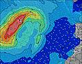 |  | 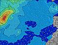 |  |  | 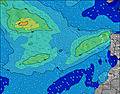 |  | ||||||||||||||
Onda Altezza (m) Direzione Periodo (s) | NNE 6 | NNE 6 | NE 6 | NNE 6 | NNE 6 | NNE 7 | NNE 7 | NNE 7 | NNE 7 | NNE 7 | NNE 7 | NNE 7 | NNE 7 | NNE 7 | NNE 7 | NNE 7 | NNE 7 | NNE 7 | NNE 7 | NNE 7 | NNE 7 | NNE 7 | NNE 7 |
Grafico delle onde | |||||||||||||||||||||||
87 | 97 | 95 | 132 | 160 | 165 | 186 | 199 | 237 | 244 | 259 | 311 | 289 | 320 | 294 | 286 | 286 | 333 | 352 | 362 | 344 | 327 | 319 | |
Vento (km/h) | |||||||||||||||||||||||
Stato del vento onshore cross-onshore cross-shore cross-offshore offshore piatto | cross-on | cross | cross | cross | cross | cross-on | cross-on | cross | cross-on | cross-on | cross-on | cross-on | cross-on | cross-on | cross-on | cross | cross-on | cross-on | cross-on | cross-on | cross-on | cross-on | cross-on |
Alta Marea | 3:55PM2.66m | 4:24AM2.30m | 4:40PM2.59m | 5:09AM2.21m | 5:24PM2.45m | ||||||||||||||||||
Basso Marea | 9:36AM0.12m | 10:14PM-0.01m | 10:19AM0.17m | 10:58PM0.09m | 11:02AM0.27m | ||||||||||||||||||
— | 7:05 | — | — | — | — | — | — | — | 7:05 | — | — | — | — | — | — | — | 7:05 | — | — | — | — | — | |
— | — | — | — | — | 8:54 | — | — | — | — | — | — | — | 8:53 | — | — | — | — | — | — | — | 8:53 | — | |
mm | — | — | — | — | — | — | — | — | — | — | — | — | — | — | — | — | — | — | — | — | — | — | — |
Temp. °C | 21 | 20 | 22 | 23 | 23 | 22 | 21 | 21 | 21 | 21 | 22 | 22 | 22 | 22 | 21 | 21 | 21 | 21 | 21 | 22 | 22 | 22 | 21 |
Gelo °C | 20 | 18 | 20 | 22 | 21 | 20 | 19 | 19 | 19 | 20 | 20 | 19 | 19 | 20 | 19 | 19 | 19 | 19 | 18 | 19 | 19 | 19 | 19 |
Onda 1 Altezza (m) Direzione Periodo (s) | WNW 9 | WNW 9 | N 7 | WNW 9 | WNW 9 | WNW 9 | WNW 9 | WNW 9 | WNW 8 | WNW 8 | WNW 8 | WNW 8 | WNW 8 | WNW 8 | WNW 8 | WNW 8 | WNW 8 | WNW 8 | WNW 8 | WNW 8 | WNW 8 | WNW 8 | WNW 8 |
56 | 32 | 27 | 32 | 45 | 45 | 30 | 30 | 28 | 27 | 26 | 13 | 13 | 13 | 13 | 13 | 12 | 11 | 6 | 6 | 6 | 6 | 6 | |
Onda 2 Altezza (m) Direzione Periodo (s) | N 8 | NW 7 | WNW 9 | NW 7 | — | — | — | — | — | — | — | — | — | — | — | — | — | — | NW 9 | W 11 | W 11 | W 11 | NW 10 |
1 | 11 | 32 | 11 | — | — | — | — | — | — | — | — | — | — | — | — | — | — | 3 | 3 | 2 | 2 | 4 | |
Onda 3 Altezza (m) Direzione Periodo (s) | — | N 8 | NW 7 | N 11 | — | — | — | — | — | — | — | — | — | — | — | — | — | — | — | — | S 18 | S 18 | — |
— | 1 | 11 | 2 | — | — | — | — | — | — | — | — | — | — | — | — | — | — | — | — | 6 | 6 | — | |
onde vento Altezza (m) Direzione Periodo (s) | NNE 6 | NNE 6 | NE 6 | NNE 6 | NNE 6 | NNE 7 | NNE 7 | NNE 7 | NNE 7 | NNE 7 | NNE 7 | NNE 7 | NNE 7 | NNE 7 | NNE 7 | NNE 7 | NNE 7 | NNE 7 | NNE 7 | NNE 7 | NNE 7 | NNE 7 | NNE 7 |
87 | 97 | 95 | 132 | 160 | 165 | 186 | 199 | 237 | 244 | 259 | 311 | 289 | 320 | 294 | 286 | 286 | 333 | 352 | 362 | 344 | 327 | 319 | |
Il più vicino Offshore or Glassy | |||||||||||||||||||||||
Distanza (km) | 32 | 267 | 32 | 32 | 519 | 32 | 405 | 321 | 248 | 321 | 377 | 223 | 248 | 248 | 248 | 250 | 250 | 248 | 223 | 223 | 223 | 248 | 248 |
Migliori previsioni per le condizioni d'onda in Lanzarote | |||||||||||||||||||||||
Migliori previsioni per le condizioni d'onda in Spain (Africa) | |||||||||||||||||||||||
Trova Onde Globale | |||||||||||||||||||||||
- Map Icons:
 Break
Break Live Wave Height (m)
 Live Wind Speed (km/h)
 Surf Rating (10 Max)
 Ocean Swells (m)
- Wind Speed (km/h)
Widget Free Surf-Forecast.com per il tuo sito
La relazione di surf / widget meteo è disponibile qui sotto per incorporare su siti esterni a titolo gratuito e fornisce una sintesi delle nostre Morro Negro previsione surf. Basta prendere il frammento di codice html da noi fornito e copiarlo nel proprio sito. È possibile scegliere la lingua preferita e unità metriche / imperiali per il feed delle previsioni surf per soddisfare le esigenze degli utenti del vostro sito .... Clicca qui per ottenere il codice.
 Nearest