
Previsioni:

Previsione a breve termineper lo più asciutto. Warm (Max 25°C Sabato pomeriggio, Min 13°C Lunedì notte). Vento sarà generalmente leggero. | ||||||||||||||||||||||
Sabato 1 | Domenica 2 | Lunedì 3 | ||||||||||||||||||||
8 AM | 11 AM | 2 PM | 5 PM | 8 PM | 11 PM | 2 AM | 5 AM | 8 AM | 11 AM | 2 PM | 5 PM | 8 PM | 11 PM | 2 AM | 5 AM | 8 AM | 11 AM | 2 PM | 5 PM | 8 PM | 11 PM | |
Mappa dell'altezza del moto ondoso |  | 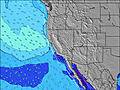 |  |  |  |  |  |  | ||||||||||||||
Onda Altezza (m) Direzione Periodo (s) | NW 8 | WNW 7 | WNW 7 | WNW 7 | WNW 8 | WNW 8 | WNW 8 | WNW 8 | NW 9 | NW 9 | WNW 9 | WNW 10 | WNW 10 | WNW 10 | WNW 10 | WNW 10 | WNW 10 | WNW 10 | WNW 10 | WNW 10 | WNW 10 | WNW 10 |
Grafico delle onde | ||||||||||||||||||||||
490 | 193 | 228 | 272 | 287 | 412 | 361 | 806 | 823 | 861 | 475 | 443 | 452 | 452 | 452 | 443 | 411 | 427 | 427 | 346 | 346 | 296 | |
Vento (km/h) | ||||||||||||||||||||||
Stato del vento onshore cross-onshore cross-shore cross-offshore offshore piatto | cross-on | cross-on | on | on | glassy | glassy | glassy | cross-on | on | on | on | on | on | glassy | glassy | glassy | glassy | cross-on | on | on | on | glassy |
Alta Marea | 1:06PM1.30m | 00:22AM1.48m | 1:35PM1.35m | 1:05AM1.31m | 2:08PM1.41m | |||||||||||||||||
Basso Marea | 6:38AM0.01m | 6:30PM0.58m | 7:04AM0.12m | 7:21PM0.56m | 7:30AM0.26m | 8:24PM0.53m | ||||||||||||||||
6:11 | — | — | — | — | — | — | 6:11 | — | — | — | — | — | — | — | 6:13 | — | — | — | — | — | — | |
— | — | — | — | 8:07 | — | — | — | — | — | — | — | 8:06 | — | — | — | — | — | — | — | 8:05 | — | |
mm | — | — | — | — | — | — | — | — | — | — | — | — | — | — | — | — | — | — | — | — | — | — |
Temp. °C | 20 | 24 | 25 | 24 | 18 | 17 | 18 | 18 | 19 | 23 | 23 | 21 | 15 | 14 | 14 | 14 | 16 | 21 | 23 | 20 | 15 | 14 |
Gelo °C | 19 | 23 | 24 | 23 | 18 | 17 | 18 | 17 | 18 | 22 | 21 | 20 | 14 | 14 | 14 | 14 | 15 | 20 | 22 | 19 | 15 | 14 |
Onda 1 Altezza (m) Direzione Periodo (s) | WNW 8 | S 13 | S 13 | S 11 | S 12 | WNW 8 | WNW 8 | WNW 9 | WNW 9 | WNW 9 | SSW 14 | SW 13 | WNW 10 | WNW 10 | WNW 10 | WNW 10 | WNW 10 | WNW 10 | WNW 10 | WNW 10 | WNW 10 | WNW 10 |
226 | 123 | 84 | 87 | 151 | 412 | 361 | 407 | 435 | 455 | 73 | 46 | 452 | 452 | 452 | 443 | 411 | 427 | 427 | 346 | 346 | 296 | |
Onda 2 Altezza (m) Direzione Periodo (s) | S 11 | S 10 | S 10 | SW 14 | SW 14 | S 12 | S 10 | S 13 | SW 14 | SSW 14 | SSW 13 | SSW 12 | SSW 13 | SSW 13 | SSW 13 | SSW 13 | SSW 13 | SSW 13 | SSW 13 | SW 13 | SW 12 | SW 12 |
89 | 51 | 51 | 95 | 53 | 78 | 78 | 163 | 97 | 76 | 53 | 50 | 69 | 68 | 68 | 67 | 67 | 67 | 66 | 42 | 40 | 39 | |
Onda 3 Altezza (m) Direzione Periodo (s) | S 13 | SW 15 | SW 14 | SSW 13 | SW 19 | S 10 | SW 14 | SW 14 | S 10 | SSW 13 | SSW 9 | S 9 | S 12 | S 12 | S 12 | SW 17 | SW 17 | S 12 | S 12 | SW 16 | SW 16 | SW 16 |
92 | 58 | 99 | 59 | 15 | 48 | 95 | 52 | 30 | 55 | 28 | 14 | 45 | 46 | 45 | 47 | 45 | 25 | 24 | 41 | 41 | 41 | |
onde vento Altezza (m) Direzione Periodo (s) | NW 8 | WNW 7 | WNW 7 | WNW 7 | WNW 8 | — | — | WNW 8 | NW 9 | NW 9 | WNW 9 | WNW 10 | — | — | — | — | — | — | — | — | — | — |
490 | 193 | 228 | 272 | 287 | — | — | 806 | 823 | 861 | 475 | 443 | — | — | — | — | — | — | — | — | — | — | |
Il più vicino Offshore or Glassy | ||||||||||||||||||||||
Distanza (km) | 34 | 151 | 151 | 122 | 0 | 0 | 0 | 28 | 34 | 177 | 177 | 151 | 114 | 0 | 0 | 0 | 0 | 18 | 151 | 151 | 34 | 0 |
Migliori previsioni per le condizioni d'onda in San Luis Obispo | ||||||||||||||||||||||
Migliori previsioni per le condizioni d'onda in United States | ||||||||||||||||||||||
Trova Onde Globale | ||||||||||||||||||||||
- Map Icons:
 Break
Break Live Wave Height (m)
 Live Wind Speed (km/h)
 Surf Rating (10 Max)
 Ocean Swells (m)
- Wind Speed (km/h)
Widget Free Surf-Forecast.com per il tuo sito
La relazione di surf / widget meteo è disponibile qui sotto per incorporare su siti esterni a titolo gratuito e fornisce una sintesi delle nostre Mouse Rock previsione surf. Basta prendere il frammento di codice html da noi fornito e copiarlo nel proprio sito. È possibile scegliere la lingua preferita e unità metriche / imperiali per il feed delle previsioni surf per soddisfare le esigenze degli utenti del vostro sito .... Clicca qui per ottenere il codice.
 Nearest