
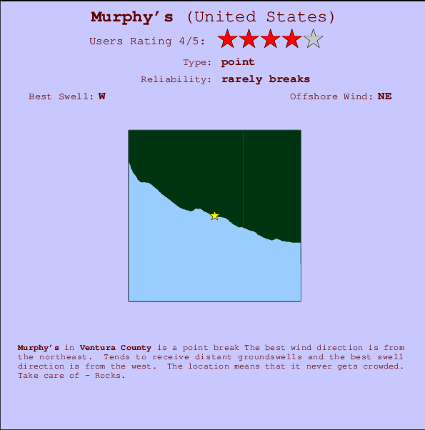
Murphy's Surf Guide
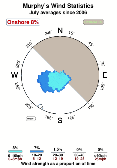
Murphy's in Ventura County is a fairly exposed point break Offshore winds are from the northeast. Tends to receive distant groundswells and the best swell direction is from the west. Even when the surf is up, crowds are unknown. Hazards include - Rocks.
Murphy's Spot Info
| Type: | Rating: | Reliability: | Todays Sea Temp*: |
|---|---|---|---|
| rarely breaks | 20.8°C*ocean temperature recorded from satellite |
Surfing Murphy's:
The best conditions reported for surf at Murphy's occur when a West swell combines with an offshore wind direction from the Northeast.

Previsioni Energia d'onda (Potenza): 12hrs


Murphy's Surf:
Sunday, 19 July 2026, 05:23 Local time| Domenica 19 | ||||
| 2AM | 5AM | 8AM | 11AM | |
| Wave (m) | ||||
| Periodo (s) | 11 | 11 | 16 | 17 |
| Vento (km/h) | ||||
| Stato del vento | cross- off |
cross- off |
cross | cross- on |
- /breaks/Murphy-s/forecasts/latest
Murphy's Surf Guide
Murphy's in Ventura County is a fairly exposed point break Offshore winds are from the northeast. Tends to receive distant groundswells and the best swell direction is from the west. Even when the surf is up, crowds are unknown. Hazards include - Rocks.
Murphy's Spot Info
Type: Rating: Reliability: Todays Sea Temp*:  Point
Point 4
4rarely breaks 20.8°C*ocean temperature recorded from satelliteSurfing Murphy's:
The best conditions reported for surf at Murphy's occur when a West swell combines with an offshore wind direction from the Northeast.
Previsioni Energia d'onda (Potenza): 12hrs
Utilizzare la scheda di navigazione in alto per visualizzare Murphy's temperatura del mare, Murphy's fotografie, Murphy's dettagliate previsioni onde, il vento e le previsioni meteo, Murphy's webcam, vento corrente da CAL - Ventura stazioni meteo e Murphy's previsioni marea. Il link United States mappe maree apre l'immagine grande, che mostra United States e dei mari circostanti. Queste mappe possono essere animate per mostrare le diverse componenti del moto ondoso, energia delle onde, periodo d'onda, altezza delle onde, insieme con le previsioni del vento e meteo, meteo corrente e osservazioni sullo stato del mare dal United States onda-boe, le navi passanti e stazioni meteo costiere. Ciascuna delle pagine di previsioni per questo surf break rappresenta uno strumento di wavefinder globale e regionale per individuare le migliori condizioni di surf nella zona intorno Murphy's.
Murphy's Surf:
Sunday, 19 July 2026, 05:23 Local timeDomenica 19 2AM 5AM 8AM 11AM Wave (m) Periodo (s) 11 11 16 17 Vento (km/h) Stato del vento cross-
offcross-
offcross cross-
on- /breaks/Murphy-s/forecasts/latest
- /breaks/Murphy-s/forecasts/latest/six_day
Murphy's Surf Guide
Murphy's in Ventura County is a fairly exposed point break Offshore winds are from the northeast. Tends to receive distant groundswells and the best swell direction is from the west. Even when the surf is up, crowds are unknown. Hazards include - Rocks.
Murphy's Spot Info
Type: Rating: Reliability: Todays Sea Temp*: Point4rarely breaks 20.8°C*ocean temperature recorded from satelliteSurfing Murphy's:
The best conditions reported for surf at Murphy's occur when a West swell combines with an offshore wind direction from the Northeast.
Previsioni Energia d'onda (Potenza): 12hrs
Utilizzare la scheda di navigazione in alto per visualizzare Murphy's temperatura del mare, Murphy's fotografie, Murphy's dettagliate previsioni onde, il vento e le previsioni meteo, Murphy's webcam, vento corrente da CAL - Ventura stazioni meteo e Murphy's previsioni marea. Il link United States mappe maree apre l'immagine grande, che mostra United States e dei mari circostanti. Queste mappe possono essere animate per mostrare le diverse componenti del moto ondoso, energia delle onde, periodo d'onda, altezza delle onde, insieme con le previsioni del vento e meteo, meteo corrente e osservazioni sullo stato del mare dal United States onda-boe, le navi passanti e stazioni meteo costiere. Ciascuna delle pagine di previsioni per questo surf break rappresenta uno strumento di wavefinder globale e regionale per individuare le migliori condizioni di surf nella zona intorno Murphy's.
Murphy's Surf:
Sunday, 19 July 2026, 05:23 Local timeDomenica 19 2AM 5AM 8AM 11AM Wave (m) Periodo (s) 11 11 16 17 Vento (km/h) Stato del vento cross-
offcross-
offcross cross-
on- /breaks/Murphy-s/forecasts/latest
Murphy's Surf Guide
Murphy's in Ventura County is a fairly exposed point break Offshore winds are from the northeast. Tends to receive distant groundswells and the best swell direction is from the west. Even when the surf is up, crowds are unknown. Hazards include - Rocks.
Murphy's Spot Info
Type: Rating: Reliability: Todays Sea Temp*: Point4rarely breaks 20.8°C*ocean temperature recorded from satelliteSurfing Murphy's:
The best conditions reported for surf at Murphy's occur when a West swell combines with an offshore wind direction from the Northeast.
Previsioni Energia d'onda (Potenza): 12hrs
Utilizzare la scheda di navigazione in alto per visualizzare Murphy's temperatura del mare, Murphy's fotografie, Murphy's dettagliate previsioni onde, il vento e le previsioni meteo, Murphy's webcam, vento corrente da CAL - Ventura stazioni meteo e Murphy's previsioni marea. Il link United States mappe maree apre l'immagine grande, che mostra United States e dei mari circostanti. Queste mappe possono essere animate per mostrare le diverse componenti del moto ondoso, energia delle onde, periodo d'onda, altezza delle onde, insieme con le previsioni del vento e meteo, meteo corrente e osservazioni sullo stato del mare dal United States onda-boe, le navi passanti e stazioni meteo costiere. Ciascuna delle pagine di previsioni per questo surf break rappresenta uno strumento di wavefinder globale e regionale per individuare le migliori condizioni di surf nella zona intorno Murphy's.
Murphy's Surf:
Sunday, 19 July 2026, 05:23 Local timeDomenica 19 2AM 5AM 8AM 11AM Wave (m) Periodo (s) 11 11 16 17 Vento (km/h) Stato del vento cross-
offcross-
offcross cross-
onTide Times:
Per Mugu Lagoon (ocean pier), California, %{dist} %{km} da %{location}.
PROSSIMA È ALLE (ora locale) rimanente alta marea bassa marea Murphy's Tide Times and Tide Chart
Live Weather:
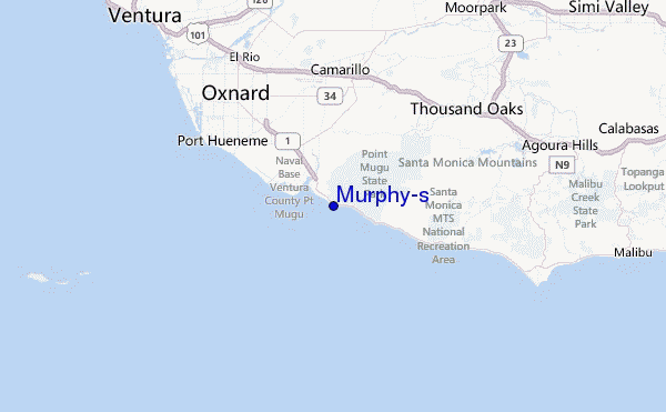
At Point Mugu Naval Air Station Airport, 6 km from Murphy's.
light winds from the ENE
(km/h)
Mist -Air temperature
18.9°COverall Murphy's Surf Consistency and Wind Distribution in Luglio
foto dall' album
Contorni: Strade e fiumi: seleziona un surf break dal menu 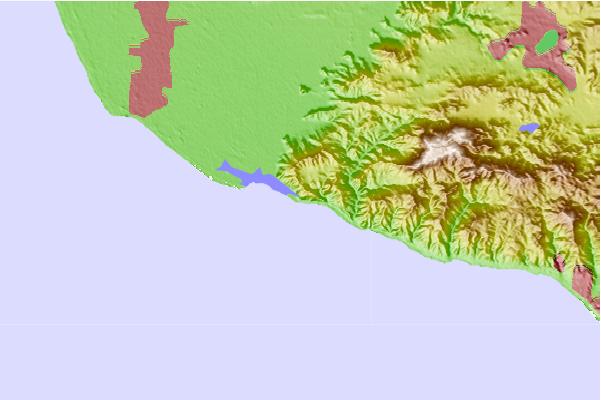
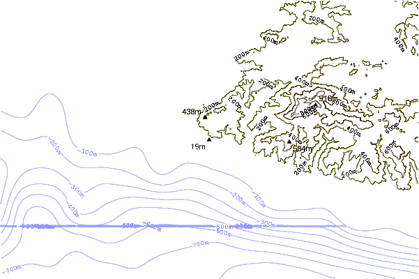
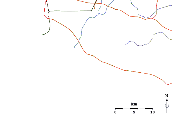
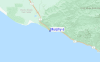
Utilizzare questa mappa sollievo per navigare CAL - Ventura surf breaks e stazioni di marea che si trovano nella zona diMurphy's
Altri surf breaks più vicini al Murphy's:
(clicca sul nome del luogo per maggiori informazioni)- Closest località surf1 mi
- Second closest località surf3 mi
- Third closest località surf3 mi
- Fourth closest località surf3 mi
- Fifth closest località surf4 mi
Onda boe più vicina a Murphy's:
- Closest Onda boa22 mi
- Second closest Onda boa24 mi
- Third closest Onda boa27 mi
- Fourth closest Onda boa29 mi
- Fifth closest Onda boa36 mi
Stazioni di marea più vicina alla Murphy's:
- Closest marea stazioneMugu Lagoon (ocean pier)2 mi
- Second closest marea stazioneOxnard9 mi
- Third closest marea stazionePort Hueneme9 mi
- Fourth closest marea stazioneOxnard Shores12 mi
- Fifth closest marea stazioneMalibu16 mi
Airports
- The closest passenger airport to Murphy's is Point Mugu Nas Airport (NTD) in USA, 7 km (4 miles) away (directly).
- The second nearest airport to Murphy's is Los Angeles International Airport (LAX), also in USA, 62 km (39 miles) away.
- Third is Burbank Glendale Pasadena Airport (BUR) in USA, 66 km (41 miles) away.
- Jack Northrop Fld Hawthorne Muni Airport (HHR) in USA is 69 km (43 miles) away.
- Long Beach Airport (LGB), also in USA is the fifth nearest airport to Murphy's and is 89 km (55 miles) away.
- /breaks/Murphy-s/forecasts/latest


 Nearest