
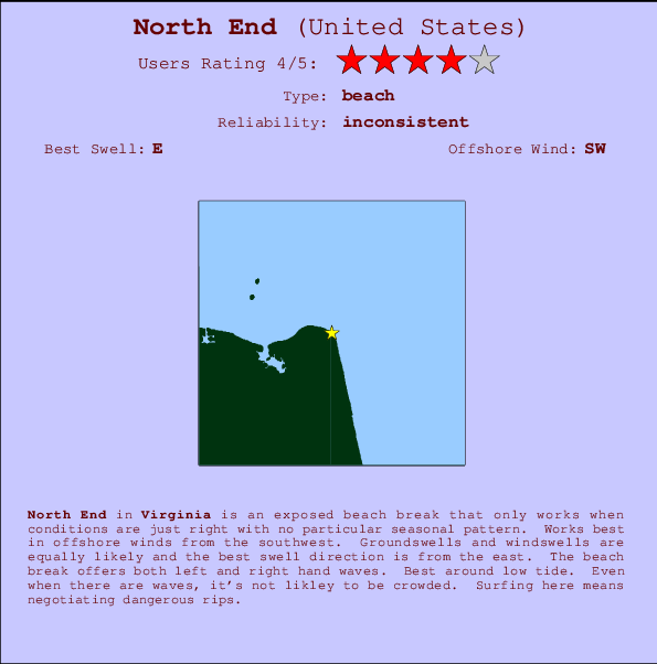
North End Surf Guide
North End in Virginia is an exposed beach break that has inconsistent surf with no particular seasonal pattern. Offshore winds are from the southwest. Most of the surf here comes from groundswells and the ideal swell direction is from the east. The beach break provides left and right handers. Best around low tide. Even when there are waves, it's not likley to be crowded. Surfing here means negotiating dangerous rips.
North End Spot Info
| Type: | Rating: | Reliability: | Todays Sea Temp*: |
|---|---|---|---|
| inconsistent | 25.8°C*ocean temperature recorded from satellite |
Surfing North End:
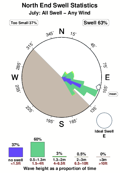
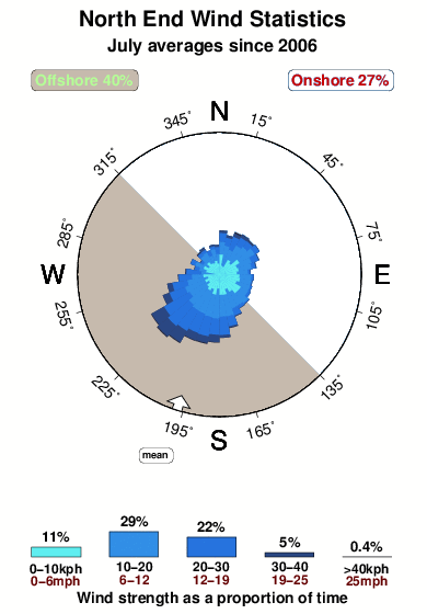
The best conditions reported for surf at North End occur when a East swell combines with an offshore wind direction from the Southwest.

Previsioni Energia d'onda (Potenza): 12hrs
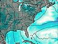

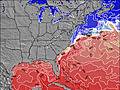
North End Surf:
Friday, 17 July 2026, 19:37 Local time| Venerdì 17 | ||||
| 5PM | 8PM | 11PM | 2AM | |
| Wave (m) | ||||
| Periodo (s) | 8 | 8 | 8 | 8 |
| Vento (km/h) | ||||
| Stato del vento | cross- on |
cross | cross | cross- off |
- /breaks/North-End/forecasts/latest
North End Surf Guide
North End in Virginia is an exposed beach break that has inconsistent surf with no particular seasonal pattern. Offshore winds are from the southwest. Most of the surf here comes from groundswells and the ideal swell direction is from the east. The beach break provides left and right handers. Best around low tide. Even when there are waves, it's not likley to be crowded. Surfing here means negotiating dangerous rips.
North End Spot Info
Type: Rating: Reliability: Todays Sea Temp*:  Beach
Beach 4
4inconsistent 25.8°C*ocean temperature recorded from satelliteSurfing North End:
The best conditions reported for surf at North End occur when a East swell combines with an offshore wind direction from the Southwest.
Previsioni Energia d'onda (Potenza): 12hrs
Utilizzare la scheda di navigazione in alto per visualizzare North End temperatura del mare, North End fotografie, North End dettagliate previsioni onde, il vento e le previsioni meteo, North End webcam, vento corrente da Virginia stazioni meteo e North End previsioni marea. Il link United States mappe maree apre l'immagine grande, che mostra United States e dei mari circostanti. Queste mappe possono essere animate per mostrare le diverse componenti del moto ondoso, energia delle onde, periodo d'onda, altezza delle onde, insieme con le previsioni del vento e meteo, meteo corrente e osservazioni sullo stato del mare dal United States onda-boe, le navi passanti e stazioni meteo costiere. Ciascuna delle pagine di previsioni per questo surf break rappresenta uno strumento di wavefinder globale e regionale per individuare le migliori condizioni di surf nella zona intorno North End.
North End Surf:
Friday, 17 July 2026, 19:37 Local timeVenerdì 17 5PM 8PM 11PM 2AM Wave (m) Periodo (s) 8 8 8 8 Vento (km/h) Stato del vento cross-
oncross cross cross-
off- /breaks/North-End/forecasts/latest
- /breaks/North-End/forecasts/latest/six_day
North End Surf Guide
North End in Virginia is an exposed beach break that has inconsistent surf with no particular seasonal pattern. Offshore winds are from the southwest. Most of the surf here comes from groundswells and the ideal swell direction is from the east. The beach break provides left and right handers. Best around low tide. Even when there are waves, it's not likley to be crowded. Surfing here means negotiating dangerous rips.
North End Spot Info
Type: Rating: Reliability: Todays Sea Temp*: Beach4inconsistent 25.8°C*ocean temperature recorded from satelliteSurfing North End:
The best conditions reported for surf at North End occur when a East swell combines with an offshore wind direction from the Southwest.
Previsioni Energia d'onda (Potenza): 12hrs
Utilizzare la scheda di navigazione in alto per visualizzare North End temperatura del mare, North End fotografie, North End dettagliate previsioni onde, il vento e le previsioni meteo, North End webcam, vento corrente da Virginia stazioni meteo e North End previsioni marea. Il link United States mappe maree apre l'immagine grande, che mostra United States e dei mari circostanti. Queste mappe possono essere animate per mostrare le diverse componenti del moto ondoso, energia delle onde, periodo d'onda, altezza delle onde, insieme con le previsioni del vento e meteo, meteo corrente e osservazioni sullo stato del mare dal United States onda-boe, le navi passanti e stazioni meteo costiere. Ciascuna delle pagine di previsioni per questo surf break rappresenta uno strumento di wavefinder globale e regionale per individuare le migliori condizioni di surf nella zona intorno North End.
North End Surf:
Friday, 17 July 2026, 19:37 Local timeVenerdì 17 5PM 8PM 11PM 2AM Wave (m) Periodo (s) 8 8 8 8 Vento (km/h) Stato del vento cross-
oncross cross cross-
off- /breaks/North-End/forecasts/latest
North End Surf Guide
North End in Virginia is an exposed beach break that has inconsistent surf with no particular seasonal pattern. Offshore winds are from the southwest. Most of the surf here comes from groundswells and the ideal swell direction is from the east. The beach break provides left and right handers. Best around low tide. Even when there are waves, it's not likley to be crowded. Surfing here means negotiating dangerous rips.
North End Spot Info
Type: Rating: Reliability: Todays Sea Temp*: Beach4inconsistent 25.8°C*ocean temperature recorded from satelliteSurfing North End:
The best conditions reported for surf at North End occur when a East swell combines with an offshore wind direction from the Southwest.
Previsioni Energia d'onda (Potenza): 12hrs
Utilizzare la scheda di navigazione in alto per visualizzare North End temperatura del mare, North End fotografie, North End dettagliate previsioni onde, il vento e le previsioni meteo, North End webcam, vento corrente da Virginia stazioni meteo e North End previsioni marea. Il link United States mappe maree apre l'immagine grande, che mostra United States e dei mari circostanti. Queste mappe possono essere animate per mostrare le diverse componenti del moto ondoso, energia delle onde, periodo d'onda, altezza delle onde, insieme con le previsioni del vento e meteo, meteo corrente e osservazioni sullo stato del mare dal United States onda-boe, le navi passanti e stazioni meteo costiere. Ciascuna delle pagine di previsioni per questo surf break rappresenta uno strumento di wavefinder globale e regionale per individuare le migliori condizioni di surf nella zona intorno North End.
North End Surf:
Friday, 17 July 2026, 19:37 Local timeVenerdì 17 5PM 8PM 11PM 2AM Wave (m) Periodo (s) 8 8 8 8 Vento (km/h) Stato del vento cross-
oncross cross cross-
offTide Times:
Per Cape Henry, Chesapeake Bay, Virginia, %{dist} %{km} da %{location}.
PROSSIMA È ALLE (ora locale) rimanente alta marea bassa marea North End Tide Times and Tide Chart
Live Weather:
At Oceana Naval Air Station Airport, 12 km from North End.
light winds from the E
(km/h)
Dry and partly cloudyAir temperature
28.9°COverall North End Surf Consistency and Wind Distribution in Luglio
foto dall' album
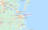
Contorni: Strade e fiumi: seleziona un surf break dal menu 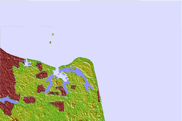

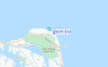
Utilizzare questa mappa sollievo per navigare Virginia surf breaks e stazioni di marea che si trovano nella zona diNorth End
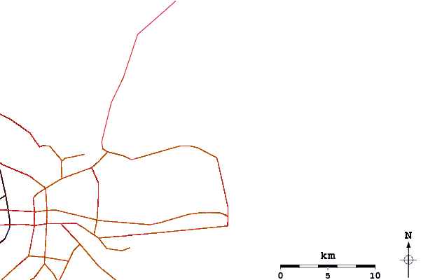
Altri surf breaks più vicini al North End:
(clicca sul nome del luogo per maggiori informazioni)- Closest località surf1 mi
- Second closest località surf4 mi
- Third closest località surf7 mi
- Fourth closest località surf9 mi
- Fifth closest località surf10 mi
Onda boe più vicina a North End:
- Closest Onda boa7 mi
- Second closest Onda boa11 mi
- Third closest Onda boa12 mi
- Fourth closest Onda boa16 mi
- Fifth closest Onda boa24 mi
Stazioni di marea più vicina alla North End:
- Closest marea stazioneCape Henry, Chesapeake Bay1 mi
- Second closest marea stazioneBroad Bay Canal, Lynnhaven Bay4 mi
- Third closest marea stazioneLong Creek, Chesapeake Bay4 mi
- Fourth closest marea stazioneHighway bridge, east of, Chesapeake Bay5 mi
- Fifth closest marea stazioneVirginia pilot's dock, Lynnhaven Inlet, Chesapeake Bay5 mi
Airports
- The closest passenger airport to North End is Oceana Nas Airport (NTU) in USA, 12 km (7 miles) away (directly).
- The second nearest airport to North End is Norfolk International Airport (ORF), also in USA, 18 km (11 miles) away.
- Third is Norfolk Ns Airport (NGU) in USA, 26 km (16 miles) away.
- Langley Afb (Hampton) Airport (LFI) in USA is 37 km (23 miles) away.
- Newport News Williamsburg International Airport (PHF), also in USA is the fifth nearest airport to North End and is 50 km (31 miles) away.
- /breaks/North-End/forecasts/latest


 Nearest