

Out Front Surf Guide
Out Front in Virginia is an exposed sandbar break that has inconsistent surf with no particular seasonal pattern. The best wind direction is from the northwest. Tends to receive a mix of groundswells and windswells and the ideal swell angle is from the east southeast. A fairly popluar wave that can sometimes get crowded
Out Front Spot Info
| Type: | Rating: | Reliability: | Todays Sea Temp*: |
|---|---|---|---|
| inconsistent | 26.1°C*ocean temperature recorded from satellite |
Surfing Out Front:
The best conditions reported for surf at Out Front occur when a East-southeast swell combines with an offshore wind direction from the Northwest.

Previsioni Energia d'onda (Potenza): 12hrs

Out Front Surf:
Monday, 20 July 2026, 21:22 Local time| Lunedì 20 | Mar | |||
| 5PM | 8PM | 11PM | 2AM | |
| Wave (m) | ||||
| Periodo (s) | 7 | 7 | 4 | 4 |
| Vento (km/h) | ||||
| Stato del vento | cross- on |
on | on | on |
- /breaks/Out-Front/forecasts/latest
Out Front Surf Guide
Out Front in Virginia is an exposed sandbar break that has inconsistent surf with no particular seasonal pattern. The best wind direction is from the northwest. Tends to receive a mix of groundswells and windswells and the ideal swell angle is from the east southeast. A fairly popluar wave that can sometimes get crowded
Out Front Spot Info
Type: Rating: Reliability: Todays Sea Temp*:  Sandbar
 1
1inconsistent 26.1°C*ocean temperature recorded from satelliteSurfing Out Front:
The best conditions reported for surf at Out Front occur when a East-southeast swell combines with an offshore wind direction from the Northwest.
Previsioni Energia d'onda (Potenza): 12hrs
Utilizzare la scheda di navigazione in alto per visualizzare Out Front temperatura del mare, Out Front fotografie, Out Front dettagliate previsioni onde, il vento e le previsioni meteo, Out Front webcam, vento corrente da Virginia stazioni meteo e Out Front previsioni marea. Il link United States mappe maree apre l'immagine grande, che mostra United States e dei mari circostanti. Queste mappe possono essere animate per mostrare le diverse componenti del moto ondoso, energia delle onde, periodo d'onda, altezza delle onde, insieme con le previsioni del vento e meteo, meteo corrente e osservazioni sullo stato del mare dal United States onda-boe, le navi passanti e stazioni meteo costiere. Ciascuna delle pagine di previsioni per questo surf break rappresenta uno strumento di wavefinder globale e regionale per individuare le migliori condizioni di surf nella zona intorno Out Front.
Out Front Surf:
Monday, 20 July 2026, 21:22 Local timeLunedì 20 Mar 5PM 8PM 11PM 2AM Wave (m) Periodo (s) 7 7 4 4 Vento (km/h) Stato del vento cross-
onon on on - /breaks/Out-Front/forecasts/latest
- /breaks/Out-Front/forecasts/latest/six_day
Out Front Surf Guide
Out Front in Virginia is an exposed sandbar break that has inconsistent surf with no particular seasonal pattern. The best wind direction is from the northwest. Tends to receive a mix of groundswells and windswells and the ideal swell angle is from the east southeast. A fairly popluar wave that can sometimes get crowded
Out Front Spot Info
Type: Rating: Reliability: Todays Sea Temp*: Sandbar1inconsistent 26.1°C*ocean temperature recorded from satelliteSurfing Out Front:
The best conditions reported for surf at Out Front occur when a East-southeast swell combines with an offshore wind direction from the Northwest.
Previsioni Energia d'onda (Potenza): 12hrs
Utilizzare la scheda di navigazione in alto per visualizzare Out Front temperatura del mare, Out Front fotografie, Out Front dettagliate previsioni onde, il vento e le previsioni meteo, Out Front webcam, vento corrente da Virginia stazioni meteo e Out Front previsioni marea. Il link United States mappe maree apre l'immagine grande, che mostra United States e dei mari circostanti. Queste mappe possono essere animate per mostrare le diverse componenti del moto ondoso, energia delle onde, periodo d'onda, altezza delle onde, insieme con le previsioni del vento e meteo, meteo corrente e osservazioni sullo stato del mare dal United States onda-boe, le navi passanti e stazioni meteo costiere. Ciascuna delle pagine di previsioni per questo surf break rappresenta uno strumento di wavefinder globale e regionale per individuare le migliori condizioni di surf nella zona intorno Out Front.
Out Front Surf:
Monday, 20 July 2026, 21:22 Local timeLunedì 20 Mar 5PM 8PM 11PM 2AM Wave (m) Periodo (s) 7 7 4 4 Vento (km/h) Stato del vento cross-
onon on on - /breaks/Out-Front/forecasts/latest
Out Front Surf Guide
Out Front in Virginia is an exposed sandbar break that has inconsistent surf with no particular seasonal pattern. The best wind direction is from the northwest. Tends to receive a mix of groundswells and windswells and the ideal swell angle is from the east southeast. A fairly popluar wave that can sometimes get crowded
Out Front Spot Info
Type: Rating: Reliability: Todays Sea Temp*: Sandbar1inconsistent 26.1°C*ocean temperature recorded from satelliteSurfing Out Front:
The best conditions reported for surf at Out Front occur when a East-southeast swell combines with an offshore wind direction from the Northwest.
Previsioni Energia d'onda (Potenza): 12hrs
Utilizzare la scheda di navigazione in alto per visualizzare Out Front temperatura del mare, Out Front fotografie, Out Front dettagliate previsioni onde, il vento e le previsioni meteo, Out Front webcam, vento corrente da Virginia stazioni meteo e Out Front previsioni marea. Il link United States mappe maree apre l'immagine grande, che mostra United States e dei mari circostanti. Queste mappe possono essere animate per mostrare le diverse componenti del moto ondoso, energia delle onde, periodo d'onda, altezza delle onde, insieme con le previsioni del vento e meteo, meteo corrente e osservazioni sullo stato del mare dal United States onda-boe, le navi passanti e stazioni meteo costiere. Ciascuna delle pagine di previsioni per questo surf break rappresenta uno strumento di wavefinder globale e regionale per individuare le migliori condizioni di surf nella zona intorno Out Front.
Out Front Surf:
Monday, 20 July 2026, 21:22 Local timeLunedì 20 Mar 5PM 8PM 11PM 2AM Wave (m) Periodo (s) 7 7 4 4 Vento (km/h) Stato del vento cross-
onon on on Tide Times:
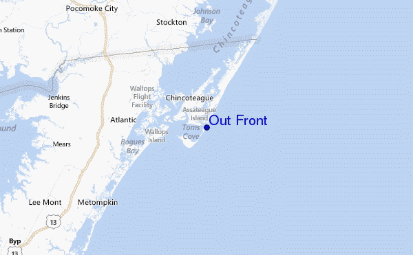
Per Assateague Beach, Toms Cove, Chincoteague Bay, Virginia, %{dist} %{km} da %{location}.
PROSSIMA È ALLE (ora locale) rimanente alta marea bassa marea Out Front Tide Times and Tide Chart
Live Weather:
At Wallops Island Airport, 12 km from Out Front.
light winds from the SE
(km/h)
Haze -Air temperature
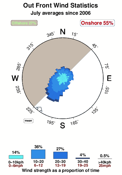
26.1°COverall Out Front Surf Consistency and Wind Distribution in Luglio
foto dall' album
Contorni: Strade e fiumi: seleziona un surf break dal menu 


Utilizzare questa mappa sollievo per navigare Virginia surf breaks e stazioni di marea che si trovano nella zona diOut Front
Altri surf breaks più vicini al Out Front:
(clicca sul nome del luogo per maggiori informazioni)- Closest località surf2 mi
- Second closest località surf25 mi
- Third closest località surf32 mi
- Fourth closest località surf32 mi
- Fifth closest località surf32 mi
Onda boe più vicina a Out Front:
- Closest Onda boa9 mi
- Second closest Onda boa53 mi
- Third closest Onda boa55 mi
- Fourth closest Onda boa55 mi
- Fifth closest Onda boa65 mi
Stazioni di marea più vicina alla Out Front:
- Closest marea stazioneAssateague Beach, Toms Cove, Chincoteague Bay2 mi
- Second closest marea stazioneChincoteague Channel, South End4 mi
- Third closest marea stazioneChincoteague Island, Lewis Creek, Chincoteague Bay4 mi
- Fourth closest marea stazioneChincoteague Island, Oyster Bay, Chincoteague Bay4 mi
- Fifth closest marea stazioneChincoteague Island, USCG Station, Chincoteague Bay4 mi
Airports
- The closest passenger airport to Out Front is Wallops Flight Facility Airport (WAL) in USA, 12 km (7 miles) away (directly).
- The second nearest airport to Out Front is Salisbury Ocean City Wicomico Rgnl Airport (SBY), also in USA, 52 km (32 miles) away.
- Third is Patuxent River Nas Airport (NHK) in USA, 104 km (65 miles) away.
- Langley Afb (Hampton) Airport (LFI) in USA is 127 km (79 miles) away.
- Cape May Co (Wildwood) Airport (WWD), also in USA is the fifth nearest airport to Out Front and is 130 km (81 miles) away.

- /breaks/Out-Front/forecasts/latest


 Nearest