
Previsioni:

Previsione a breve termineper lo più asciutto. Warm (Max 21°C Venerdì pomeriggio, Min 19°C Venerdì notte). Principalmente raffiche di vento. | |||||||||||||||||||
Ven 24 | Sabato 25 | Domenica 26 | |||||||||||||||||
4 PM | 7 PM | 10 PM | 1 AM | 4 AM | 7 AM | 10 AM | 1 PM | 4 PM | 7 PM | 10 PM | 1 AM | 4 AM | 7 AM | 10 AM | 1 PM | 4 PM | 7 PM | 10 PM | |
Mappa dell'altezza del moto ondoso |  |  | 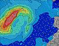 |  |  | 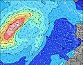 |  | ||||||||||||
Onda Altezza (m) Direzione Periodo (s) | NNE 8 | NNE 8 | NNE 8 | NNE 8 | NNE 8 | NNE 8 | NNE 8 | NNE 8 | NNE 8 | NNE 8 | NNE 8 | NNE 8 | NNE 8 | NNE 8 | NNE 8 | NNE 8 | NNE 8 | NNE 8 | NNE 8 |
Grafico delle onde | |||||||||||||||||||
604 | 588 | 588 | 588 | 654 | 691 | 784 | 809 | 809 | 845 | 908 | 845 | 908 | 956 | 941 | 850 | 745 | 686 | 599 | |
Vento (km/h) | |||||||||||||||||||
Stato del vento onshore cross-onshore cross-shore cross-offshore offshore piatto | on | on | on | on | on | on | on | on | on | on | on | on | on | on | on | on | on | on | on |
Alta Marea | 11:27PM1.67m | 11:53AM1.82m | 00:23AM1.76m | 12:42PM1.94m | |||||||||||||||
Basso Marea | 5:13PM0.80m | 5:31AM0.79m | 6:13PM0.70m | 6:23AM0.69m | 6:59PM0.58m | ||||||||||||||
— | — | — | — | — | 7:09 | — | — | — | — | — | — | — | 7:11 | — | — | — | — | — | |
— | 8:51 | — | — | — | — | — | — | — | 8:51 | — | — | — | — | — | — | — | 8:50 | — | |
mm | — | — | — | — | — | — | — | — | — | — | — | — | — | — | — | — | — | — | — |
Temp. °C | 21 | 20 | 19 | 19 | 19 | 19 | 20 | 20 | 21 | 20 | 20 | 20 | 19 | 20 | 20 | 21 | 21 | 21 | 20 |
Gelo °C | 17 | 15 | 14 | 15 | 14 | 14 | 15 | 15 | 16 | 15 | 16 | 16 | 14 | 16 | 16 | 18 | 18 | 18 | 17 |
Onda 1 Altezza (m) Direzione Periodo (s) | WNW 8 | WNW 8 | WNW 8 | WNW 8 | WNW 8 | WNW 8 | WNW 8 | WNW 8 | — | NW 11 | — | W 11 | NW 10 | NW 10 | WNW 10 | WNW 10 | WNW 10 | WNW 10 | WNW 10 |
14 | 7 | 7 | 7 | 6 | 7 | 6 | 6 | — | 5 | — | 2 | 4 | 4 | 10 | 10 | 10 | 9 | 9 | |
Onda 2 Altezza (m) Direzione Periodo (s) | — | — | — | — | — | — | — | — | — | — | — | — | — | — | — | — | — | — | — |
— | — | — | — | — | — | — | — | — | — | — | — | — | — | — | — | — | — | — | |
Onda 3 Altezza (m) Direzione Periodo (s) | — | — | — | — | — | — | — | — | — | — | — | — | — | — | — | — | — | — | — |
— | — | — | — | — | — | — | — | — | — | — | — | — | — | — | — | — | — | — | |
onde vento Altezza (m) Direzione Periodo (s) | NNE 8 | NNE 8 | NNE 8 | NNE 8 | NNE 8 | NNE 8 | NNE 8 | NNE 8 | NNE 8 | NNE 8 | NNE 8 | NNE 8 | NNE 8 | NNE 8 | NNE 8 | NNE 8 | NNE 8 | NNE 8 | NNE 8 |
604 | 588 | 588 | 588 | 654 | 691 | 784 | 809 | 809 | 845 | 908 | 845 | 908 | 956 | 941 | 850 | 745 | 686 | 599 | |
Il più vicino Offshore or Glassy | |||||||||||||||||||
Distanza (km) | 326 | 326 | 326 | 326 | 402 | 326 | 325 | 325 | 326 | 326 | 407 | 325 | 326 | 326 | 325 | 326 | 326 | 326 | 329 |
Migliori previsioni per le condizioni d'onda in Lanzarote | |||||||||||||||||||
Migliori previsioni per le condizioni d'onda in Spain (Africa) | |||||||||||||||||||
Trova Onde Globale | |||||||||||||||||||
- Map Icons:
 Break
Break Live Wave Height (m)
 Live Wind Speed (km/h)
 Surf Rating (10 Max)
 Ocean Swells (m)
- Wind Speed (km/h)
Widget Free Surf-Forecast.com per il tuo sito
La relazione di surf / widget meteo è disponibile qui sotto per incorporare su siti esterni a titolo gratuito e fornisce una sintesi delle nostre Outside Reef previsione surf. Basta prendere il frammento di codice html da noi fornito e copiarlo nel proprio sito. È possibile scegliere la lingua preferita e unità metriche / imperiali per il feed delle previsioni surf per soddisfare le esigenze degli utenti del vostro sito .... Clicca qui per ottenere il codice.
 Nearest