

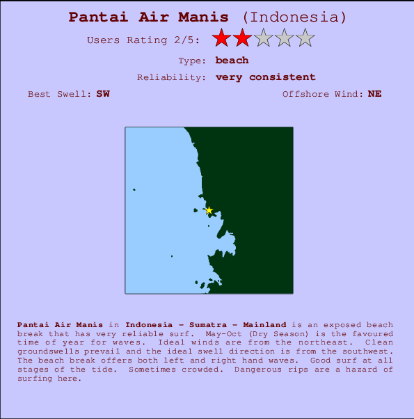
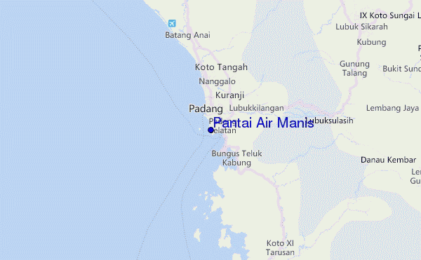
Pantai Air Manis Surf Guide
Pantai Air Manis in Indonesia - Sumatra - Mainland is an exposed beach break that is usually a safe bet. May-Oct (Dry Season) is the favoured time of year for waves. Works best in offshore winds from the northeast. Most of the surf here comes from groundswells and the optimum swell angle is from the southwest. The beach breaks offer lefts and rights. Good surf at all stages of the tide. When the surf is up, it can get quite busy in the water. Dangerous rips are a hazard of surfing here.
Pantai Air Manis Spot Info
| Type: | Rating: | Reliability: | Todays Sea Temp*: |
|---|---|---|---|
| very consistent | 29.5°C*ocean temperature recorded from satellite |
Surfing Pantai Air Manis:
The best conditions reported for surf at Pantai Air Manis occur when a Southwest swell combines with an offshore wind direction from the Northeast.

Previsioni Energia d'onda (Potenza): 12hrs


Pantai Air Manis Surf:
Thursday, 16 July 2026, 05:49 Local time| Giovedì 16 | ||||
| 4AM | 7AM | 10AM | 1PM | |
| Wave (m) | ||||
| Periodo (s) | 15 | 15 | 15 | 15 |
| Vento (km/h) | ||||
| Stato del vento | cross- off |
off | glass | on |
- /breaks/Pantai-Air-Manis/forecasts/latest
Pantai Air Manis Surf Guide
Pantai Air Manis in Indonesia - Sumatra - Mainland is an exposed beach break that is usually a safe bet. May-Oct (Dry Season) is the favoured time of year for waves. Works best in offshore winds from the northeast. Most of the surf here comes from groundswells and the optimum swell angle is from the southwest. The beach breaks offer lefts and rights. Good surf at all stages of the tide. When the surf is up, it can get quite busy in the water. Dangerous rips are a hazard of surfing here.
Pantai Air Manis Spot Info
Type: Rating: Reliability: Todays Sea Temp*:  Beach
Beach 2
2very consistent 29.5°C*ocean temperature recorded from satelliteSurfing Pantai Air Manis:
The best conditions reported for surf at Pantai Air Manis occur when a Southwest swell combines with an offshore wind direction from the Northeast.
Previsioni Energia d'onda (Potenza): 12hrs
Utilizzare la scheda di navigazione in alto per visualizzare Pantai Air Manis temperatura del mare, Pantai Air Manis fotografie, Pantai Air Manis dettagliate previsioni onde, il vento e le previsioni meteo, Pantai Air Manis webcam, vento corrente da Sumatra - Mainland stazioni meteo e Pantai Air Manis previsioni marea. Il link Indonesia mappe maree apre l'immagine grande, che mostra Indonesia e dei mari circostanti. Queste mappe possono essere animate per mostrare le diverse componenti del moto ondoso, energia delle onde, periodo d'onda, altezza delle onde, insieme con le previsioni del vento e meteo, meteo corrente e osservazioni sullo stato del mare dal Indonesia onda-boe, le navi passanti e stazioni meteo costiere. Ciascuna delle pagine di previsioni per questo surf break rappresenta uno strumento di wavefinder globale e regionale per individuare le migliori condizioni di surf nella zona intorno Pantai Air Manis.
Pantai Air Manis Surf:
Thursday, 16 July 2026, 05:49 Local timeGiovedì 16 4AM 7AM 10AM 1PM Wave (m) Periodo (s) 15 15 15 15 Vento (km/h) Stato del vento cross-
offoff glass on - /breaks/Pantai-Air-Manis/forecasts/latest
- /breaks/Pantai-Air-Manis/forecasts/latest/six_day
Pantai Air Manis Surf Guide
Pantai Air Manis in Indonesia - Sumatra - Mainland is an exposed beach break that is usually a safe bet. May-Oct (Dry Season) is the favoured time of year for waves. Works best in offshore winds from the northeast. Most of the surf here comes from groundswells and the optimum swell angle is from the southwest. The beach breaks offer lefts and rights. Good surf at all stages of the tide. When the surf is up, it can get quite busy in the water. Dangerous rips are a hazard of surfing here.
Pantai Air Manis Spot Info
Type: Rating: Reliability: Todays Sea Temp*: Beach2very consistent 29.5°C*ocean temperature recorded from satelliteSurfing Pantai Air Manis:
The best conditions reported for surf at Pantai Air Manis occur when a Southwest swell combines with an offshore wind direction from the Northeast.
Previsioni Energia d'onda (Potenza): 12hrs
Utilizzare la scheda di navigazione in alto per visualizzare Pantai Air Manis temperatura del mare, Pantai Air Manis fotografie, Pantai Air Manis dettagliate previsioni onde, il vento e le previsioni meteo, Pantai Air Manis webcam, vento corrente da Sumatra - Mainland stazioni meteo e Pantai Air Manis previsioni marea. Il link Indonesia mappe maree apre l'immagine grande, che mostra Indonesia e dei mari circostanti. Queste mappe possono essere animate per mostrare le diverse componenti del moto ondoso, energia delle onde, periodo d'onda, altezza delle onde, insieme con le previsioni del vento e meteo, meteo corrente e osservazioni sullo stato del mare dal Indonesia onda-boe, le navi passanti e stazioni meteo costiere. Ciascuna delle pagine di previsioni per questo surf break rappresenta uno strumento di wavefinder globale e regionale per individuare le migliori condizioni di surf nella zona intorno Pantai Air Manis.
Pantai Air Manis Surf:
Thursday, 16 July 2026, 05:49 Local timeGiovedì 16 4AM 7AM 10AM 1PM Wave (m) Periodo (s) 15 15 15 15 Vento (km/h) Stato del vento cross-
offoff glass on - /breaks/Pantai-Air-Manis/forecasts/latest
Pantai Air Manis Surf Guide
Pantai Air Manis in Indonesia - Sumatra - Mainland is an exposed beach break that is usually a safe bet. May-Oct (Dry Season) is the favoured time of year for waves. Works best in offshore winds from the northeast. Most of the surf here comes from groundswells and the optimum swell angle is from the southwest. The beach breaks offer lefts and rights. Good surf at all stages of the tide. When the surf is up, it can get quite busy in the water. Dangerous rips are a hazard of surfing here.
Pantai Air Manis Spot Info
Type: Rating: Reliability: Todays Sea Temp*: Beach2very consistent 29.5°C*ocean temperature recorded from satelliteSurfing Pantai Air Manis:
The best conditions reported for surf at Pantai Air Manis occur when a Southwest swell combines with an offshore wind direction from the Northeast.
Previsioni Energia d'onda (Potenza): 12hrs
Utilizzare la scheda di navigazione in alto per visualizzare Pantai Air Manis temperatura del mare, Pantai Air Manis fotografie, Pantai Air Manis dettagliate previsioni onde, il vento e le previsioni meteo, Pantai Air Manis webcam, vento corrente da Sumatra - Mainland stazioni meteo e Pantai Air Manis previsioni marea. Il link Indonesia mappe maree apre l'immagine grande, che mostra Indonesia e dei mari circostanti. Queste mappe possono essere animate per mostrare le diverse componenti del moto ondoso, energia delle onde, periodo d'onda, altezza delle onde, insieme con le previsioni del vento e meteo, meteo corrente e osservazioni sullo stato del mare dal Indonesia onda-boe, le navi passanti e stazioni meteo costiere. Ciascuna delle pagine di previsioni per questo surf break rappresenta uno strumento di wavefinder globale e regionale per individuare le migliori condizioni di surf nella zona intorno Pantai Air Manis.
Pantai Air Manis Surf:
Thursday, 16 July 2026, 05:49 Local timeGiovedì 16 4AM 7AM 10AM 1PM Wave (m) Periodo (s) 15 15 15 15 Vento (km/h) Stato del vento cross-
offoff glass on Tide Times:
A Pantai Air Manis (0 km).
PROSSIMA È ALLE (ora locale) rimanente alta marea bassa marea Pantai Air Manis Tide Times and Tide Chart
Live Weather:
At Minangkabau Airport, 25 km from Pantai Air Manis.
calm
(km/h)Air temperature
24°COverall Pantai Air Manis Surf Consistency and Wind Distribution in Luglio


Wind stats for Pantai Air Manis: see the variation in direction and stength by month.
foto dall' album
Contorni: Strade e fiumi: seleziona un surf break dal menu 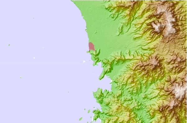
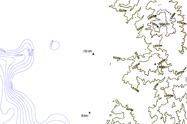
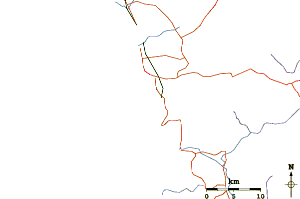
Utilizzare questa mappa sollievo per navigare Sumatra - Mainland surf breaks e stazioni di marea che si trovano nella zona diPantai Air Manis
Altri surf breaks più vicini al Pantai Air Manis:
(clicca sul nome del luogo per maggiori informazioni)- Closest località surf90 mi
- Second closest località surf92 mi
- Third closest località surf94 mi
- Fourth closest località surf94 mi
- Fifth closest località surf96 mi
Onda boe più vicina a Pantai Air Manis:
- Closest Onda boa2369 mi
- Second closest Onda boa2443 mi
- Third closest Onda boa2620 mi
- Fourth closest Onda boa2634 mi
- Fifth closest Onda boa2807 mi
Stazioni di marea più vicina alla Pantai Air Manis:
- Closest marea stazionePariaman31 mi
- Second closest marea stazioneKualatungkal215 mi
- Third closest marea stazioneSibolga219 mi
- Fourth closest marea stazioneBengkulu234 mi
- Fifth closest marea stazioneMelaka255 mi
Airports
- The nearest passenger airport to Pantai Air Manis is Tabing (Padang) Airport (PDG) in Indonesia, which is 13 km (8 miles) away (directly).
- The second closest airport to Pantai Air Manis is Sultan Syarif Kasim Ii (Pekanbaru) Airport (PKU), also in Indonesia, 202 km (125 miles) away.
- /breaks/Pantai-Air-Manis/forecasts/latest

 Nearest