
Previsioni:

Previsione a breve terminePioggia moderata (Totale 15mm), più pesante Venerdì mattina. Very mild (Max 17°C Venerdì pomeriggio, Min 9°C Venerdì notte). Venti in aumento (venti deboli da N Venerdì mattina, venti freschi da SSW per venerdì notte). | ||||||||||||||||||||||||
Mer 15 | Giovedì 16 | Venerdì 17 | 18 | |||||||||||||||||||||
12 PM | 3 PM | 6 PM | 9 PM | 12 AM | 3 AM | 6 AM | 9 AM | 12 PM | 3 PM | 6 PM | 9 PM | 12 AM | 3 AM | 6 AM | 9 AM | 12 PM | 3 PM | 6 PM | 9 PM | 12 AM | 3 AM | 6 AM | 9 AM | |
Mappa dell'altezza del moto ondoso |  | 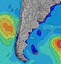 |  | 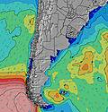 | 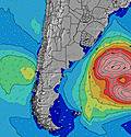 |  | 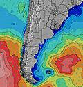 |  |  |  | ||||||||||||||
Onda Altezza (m) Direzione Periodo (s) | NE 8 | NE 7 | NE 7 | NE 7 | NE 7 | NE 6 | NE 7 | ENE 7 | ENE 7 | ENE 7 | ENE 8 | NE 7 | NE 6 | NE 7 | ENE 7 | ENE 7 | ENE 8 | ENE 8 | ENE 8 | ENE 8 | ENE 8 | ENE 8 | ENE 9 | ENE 10 |
Grafico delle onde | ||||||||||||||||||||||||
69 | 65 | 75 | 65 | 85 | 120 | 124 | 81 | 102 | 111 | 150 | 160 | 122 | 135 | 196 | 164 | 202 | 211 | 185 | 157 | 144 | 122 | 149 | 201 | |
Vento (km/h) | ||||||||||||||||||||||||
Stato del vento onshore cross-onshore cross-shore cross-offshore offshore piatto | cross-off | cross-off | cross-off | cross-off | cross-off | cross-off | cross-off | cross-off | cross-off | cross-off | cross | cross-off | cross-off | cross-off | cross-off | cross | cross-off | off | cross-off | cross | cross | cross | cross | cross-on |
Alta Marea | 7:41PM1.91m | 8:43AM1.02m | 8:35PM1.93m | 9:36AM1.02m | 9:30PM1.90m | |||||||||||||||||||
Basso Marea | 1:25PM0.71m | 3:45AM0.09m | 2:31PM0.68m | 4:37AM0.09m | 3:30PM0.65m | 5:26AM0.14m | ||||||||||||||||||
— | — | — | — | — | — | 8:02 | — | — | — | — | — | — | — | 8:02 | — | — | — | — | — | — | — | 8:00 | — | |
— | 5:49 | — | — | — | — | — | — | — | 5:50 | — | — | — | — | — | — | — | 5:51 | — | — | — | — | — | 5:51 | |
mm | — | — | — | — | — | — | — | — | — | — | — | — | 1 | 1 | 1 | 2 | 4 | 4 | 2 | — | — | — | — | — |
Temp. °C | 12 | 15 | 15 | 12 | 13 | 13 | 13 | 12 | 15 | 16 | 14 | 14 | 15 | 15 | 14 | 13 | 16 | 17 | 16 | 13 | 12 | 10 | 9 | 9 |
Gelo °C | 7 | 11 | 12 | 8 | 9 | 10 | 11 | 9 | 12 | 13 | 10 | 10 | 12 | 13 | 12 | 10 | 16 | 16 | 15 | 10 | 7 | 3 | 2 | 2 |
Onda 1 Altezza (m) Direzione Periodo (s) | ESE 10 | ESE 10 | ESE 10 | S 9 | SSW 8 | NE 7 | ENE 7 | ENE 7 | ENE 7 | S 9 | S 9 | S 9 | S 8 | NE 7 | S 8 | ENE 7 | ENE 8 | ENE 8 | ENE 8 | ENE 8 | ENE 8 | ENE 8 | ENE 9 | ENE 10 |
10 | 10 | 10 | 6 | 7 | 85 | 78 | 81 | 102 | 41 | 39 | 37 | 34 | 135 | 21 | 164 | 202 | 211 | 185 | 157 | 144 | 122 | 149 | 201 | |
Onda 2 Altezza (m) Direzione Periodo (s) | SW 6 | SW 5 | S 10 | ESE 10 | SE 10 | SSW 8 | SSW 8 | S 10 | S 10 | E 11 | E 11 | E 10 | E 10 | S 8 | S 12 | S 8 | S 8 | S 8 | S 14 | S 13 | S 13 | S 12 | — | — |
1 | 1 | 2 | 10 | 4 | 12 | 11 | 17 | 45 | 22 | 21 | 34 | 19 | 21 | 3 | 20 | 11 | 10 | 37 | 31 | 30 | 26 | — | — | |
Onda 3 Altezza (m) Direzione Periodo (s) | S 11 | S 11 | SW 5 | SW 5 | S 11 | S 11 | S 10 | SSW 7 | E 11 | S 15 | S 14 | S 13 | S 13 | E 10 | S 18 | S 16 | S 16 | S 15 | S 8 | S 7 | S 7 | S 7 | — | — |
2 | 2 | 1 | 1 | 3 | 2 | 8 | 10 | 10 | 17 | 16 | 14 | 13 | 34 | 6 | 21 | 20 | 39 | 10 | 4 | 4 | 1 | — | — | |
onde vento Altezza (m) Direzione Periodo (s) | NE 8 | NE 7 | NE 7 | NE 7 | NE 7 | NE 6 | NE 7 | — | — | ENE 7 | ENE 8 | NE 7 | NE 6 | — | ENE 7 | — | — | — | — | SSW 3 | SSW 4 | SW 4 | SSW 5 | SSW 5 |
69 | 65 | 75 | 65 | 85 | 120 | 124 | — | — | 111 | 150 | 160 | 122 | — | 196 | — | — | — | — | 3 | 7 | 15 | 57 | 113 | |
Il più vicino Offshore or Glassy | ||||||||||||||||||||||||
Distanza (km) | 424 | 414 | 0 | 41 | 13 | 0 | 0 | 4 | 4 | 4 | 4 | 4 | 4 | 4 | 4 | 4 | 0 | 0 | 0 | 6 | 177 | 422 | 422 | 109 |
Migliori previsioni per le condizioni d'onda in Provincia de Buenos Aires | ||||||||||||||||||||||||
Migliori previsioni per le condizioni d'onda in Argentina | ||||||||||||||||||||||||
Trova Onde Globale | ||||||||||||||||||||||||
- Map Icons:
 Break
Break Live Wave Height (m)
 Live Wind Speed (km/h)
 Surf Rating (10 Max)
 Ocean Swells (m)
- Wind Speed (km/h)
Widget Free Surf-Forecast.com per il tuo sito
La relazione di surf / widget meteo è disponibile qui sotto per incorporare su siti esterni a titolo gratuito e fornisce una sintesi delle nostre Playa Acantilados previsione surf. Basta prendere il frammento di codice html da noi fornito e copiarlo nel proprio sito. È possibile scegliere la lingua preferita e unità metriche / imperiali per il feed delle previsioni surf per soddisfare le esigenze degli utenti del vostro sito .... Clicca qui per ottenere il codice.
 Nearest