
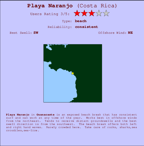
Playa Naranjo Surf Guide
Playa Naranjo in Guanacaste is an exposed beach break that has consistent surf and can work at any time of the year. The best wind direction is from the northeast. Clean groundswells prevail and the ideal swell direction is from the southwest. Waves at the beach are both lefts and rights. It very rarely gets crowded here. Beware of rocks, sharks,sea crcodiles,sea-lice.
Playa Naranjo Spot Info
| Type: | Rating: | Reliability: | Todays Sea Temp*: |
|---|---|---|---|
| consistent | 29.6°C*ocean temperature recorded from satellite |
Surfing Playa Naranjo:
The best conditions reported for surf at Playa Naranjo occur when a Southwest swell combines with an offshore wind direction from the Northeast.

Previsioni Energia d'onda (Potenza): 12hrs


Playa Naranjo Surf:
Saturday, 18 July 2026, 05:11 Local time| Sabato 18 | ||||
| 3AM | 6AM | 9AM | 12PM | |
| Wave (m) | ||||
| Periodo (s) | 13 | 13 | 13 | 13 |
| Vento (km/h) | ||||
| Stato del vento | off | off | cross- off |
off |
- /breaks/Playa-Naranjo/forecasts/latest
Playa Naranjo Surf Guide
Playa Naranjo in Guanacaste is an exposed beach break that has consistent surf and can work at any time of the year. The best wind direction is from the northeast. Clean groundswells prevail and the ideal swell direction is from the southwest. Waves at the beach are both lefts and rights. It very rarely gets crowded here. Beware of rocks, sharks,sea crcodiles,sea-lice.
Playa Naranjo Spot Info
Type: Rating: Reliability: Todays Sea Temp*:  Beach
Beach 3
3consistent 29.6°C*ocean temperature recorded from satelliteSurfing Playa Naranjo:
The best conditions reported for surf at Playa Naranjo occur when a Southwest swell combines with an offshore wind direction from the Northeast.
Previsioni Energia d'onda (Potenza): 12hrs
Utilizzare la scheda di navigazione in alto per visualizzare Playa Naranjo temperatura del mare, Playa Naranjo fotografie, Playa Naranjo dettagliate previsioni onde, il vento e le previsioni meteo, Playa Naranjo webcam, vento corrente da Guanacaste stazioni meteo e Playa Naranjo previsioni marea. Il link Costa Rica mappe maree apre l'immagine grande, che mostra Costa Rica e dei mari circostanti. Queste mappe possono essere animate per mostrare le diverse componenti del moto ondoso, energia delle onde, periodo d'onda, altezza delle onde, insieme con le previsioni del vento e meteo, meteo corrente e osservazioni sullo stato del mare dal Costa Rica onda-boe, le navi passanti e stazioni meteo costiere. Ciascuna delle pagine di previsioni per questo surf break rappresenta uno strumento di wavefinder globale e regionale per individuare le migliori condizioni di surf nella zona intorno Playa Naranjo.
Playa Naranjo Surf:
Saturday, 18 July 2026, 05:11 Local timeSabato 18 3AM 6AM 9AM 12PM Wave (m) Periodo (s) 13 13 13 13 Vento (km/h) Stato del vento off off cross-
offoff - /breaks/Playa-Naranjo/forecasts/latest
- /breaks/Playa-Naranjo/forecasts/latest/six_day
Playa Naranjo Surf Guide
Playa Naranjo in Guanacaste is an exposed beach break that has consistent surf and can work at any time of the year. The best wind direction is from the northeast. Clean groundswells prevail and the ideal swell direction is from the southwest. Waves at the beach are both lefts and rights. It very rarely gets crowded here. Beware of rocks, sharks,sea crcodiles,sea-lice.
Playa Naranjo Spot Info
Type: Rating: Reliability: Todays Sea Temp*: Beach3consistent 29.6°C*ocean temperature recorded from satelliteSurfing Playa Naranjo:
The best conditions reported for surf at Playa Naranjo occur when a Southwest swell combines with an offshore wind direction from the Northeast.
Previsioni Energia d'onda (Potenza): 12hrs
Utilizzare la scheda di navigazione in alto per visualizzare Playa Naranjo temperatura del mare, Playa Naranjo fotografie, Playa Naranjo dettagliate previsioni onde, il vento e le previsioni meteo, Playa Naranjo webcam, vento corrente da Guanacaste stazioni meteo e Playa Naranjo previsioni marea. Il link Costa Rica mappe maree apre l'immagine grande, che mostra Costa Rica e dei mari circostanti. Queste mappe possono essere animate per mostrare le diverse componenti del moto ondoso, energia delle onde, periodo d'onda, altezza delle onde, insieme con le previsioni del vento e meteo, meteo corrente e osservazioni sullo stato del mare dal Costa Rica onda-boe, le navi passanti e stazioni meteo costiere. Ciascuna delle pagine di previsioni per questo surf break rappresenta uno strumento di wavefinder globale e regionale per individuare le migliori condizioni di surf nella zona intorno Playa Naranjo.
Playa Naranjo Surf:
Saturday, 18 July 2026, 05:11 Local timeSabato 18 3AM 6AM 9AM 12PM Wave (m) Periodo (s) 13 13 13 13 Vento (km/h) Stato del vento off off cross-
offoff - /breaks/Playa-Naranjo/forecasts/latest
Playa Naranjo Surf Guide
Playa Naranjo in Guanacaste is an exposed beach break that has consistent surf and can work at any time of the year. The best wind direction is from the northeast. Clean groundswells prevail and the ideal swell direction is from the southwest. Waves at the beach are both lefts and rights. It very rarely gets crowded here. Beware of rocks, sharks,sea crcodiles,sea-lice.
Playa Naranjo Spot Info
Type: Rating: Reliability: Todays Sea Temp*: Beach3consistent 29.6°C*ocean temperature recorded from satelliteSurfing Playa Naranjo:
The best conditions reported for surf at Playa Naranjo occur when a Southwest swell combines with an offshore wind direction from the Northeast.
Previsioni Energia d'onda (Potenza): 12hrs
Utilizzare la scheda di navigazione in alto per visualizzare Playa Naranjo temperatura del mare, Playa Naranjo fotografie, Playa Naranjo dettagliate previsioni onde, il vento e le previsioni meteo, Playa Naranjo webcam, vento corrente da Guanacaste stazioni meteo e Playa Naranjo previsioni marea. Il link Costa Rica mappe maree apre l'immagine grande, che mostra Costa Rica e dei mari circostanti. Queste mappe possono essere animate per mostrare le diverse componenti del moto ondoso, energia delle onde, periodo d'onda, altezza delle onde, insieme con le previsioni del vento e meteo, meteo corrente e osservazioni sullo stato del mare dal Costa Rica onda-boe, le navi passanti e stazioni meteo costiere. Ciascuna delle pagine di previsioni per questo surf break rappresenta uno strumento di wavefinder globale e regionale per individuare le migliori condizioni di surf nella zona intorno Playa Naranjo.
Playa Naranjo Surf:
Saturday, 18 July 2026, 05:11 Local timeSabato 18 3AM 6AM 9AM 12PM Wave (m) Periodo (s) 13 13 13 13 Vento (km/h) Stato del vento off off cross-
offoff Tide Times:
Per El Laberinto, %{dist} %{km} da %{location}.
PROSSIMA È ALLE (ora locale) rimanente alta marea bassa marea Playa Naranjo Tide Times and Tide Chart
Live Weather:
At La Vega wx, 140 km from Playa Naranjo.
- Air temperature
19°COverall Playa Naranjo Surf Consistency and Wind Distribution in Luglio


Wind stats for Playa Naranjo: see the variation in direction and stength by month.
foto dall' album
Contorni: Strade e fiumi: seleziona un surf break dal menu 


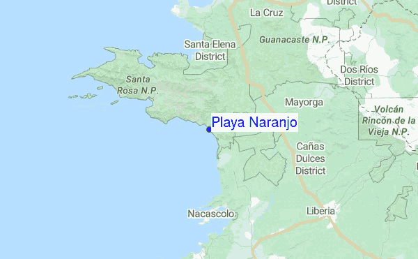
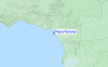
Utilizzare questa mappa sollievo per navigare Guanacaste surf breaks e stazioni di marea che si trovano nella zona diPlaya Naranjo
Altri surf breaks più vicini al Playa Naranjo:
(clicca sul nome del luogo per maggiori informazioni)- Closest località surf0 mi
- Second closest località surf4 mi
- Third closest località surf9 mi
- Fourth closest località surf12 mi
- Fifth closest località surf22 mi
Onda boe più vicina a Playa Naranjo:
- Closest Onda boa503 mi
- Second closest Onda boa629 mi
- Third closest Onda boa953 mi
- Fourth closest Onda boa1039 mi
- Fifth closest Onda boa1049 mi
Stazioni di marea più vicina alla Playa Naranjo:
- Closest marea stazioneSan Juan del Sur34 mi
- Second closest marea stazionePunta Arenas81 mi
- Third closest marea stazioneChacarita83 mi
- Fourth closest marea stazioneMasachapa89 mi
- Fifth closest marea stazioneSan Juan del Norte (Greytown)135 mi
Airports
- The closest passenger airport to Playa Naranjo is Daniel Oduber Quiros International (Liberia) Airport (LIR) in Costa Rica, 27 km (17 miles) away (directly).
- The second nearest airport to Playa Naranjo is Nosara Airport (NOB), also in Costa Rica, 91 km (57 miles) away.
- Third is Managua International Airport (MGA) in Nicaragua, 159 km (99 miles) away.
- Juan Santamaria International Airport (SJO) in Costa Rica is 184 km (114 miles) away.
- Quepos Managua Airport (XQP), also in Costa Rica is the fifth nearest airport to Playa Naranjo and is 226 km (140 miles) away.
- /breaks/Playa-Naranjo/forecasts/latest

 Nearest