
Previsioni:

Previsione a breve termineQualche pioggerella, più pesante durante sabato mattina. Very mild (Max 14°C Venerdì pomeriggio, Min 9°C mercoledì notte). Venti decrescenti (venti freschi da SSW mercoledì pomeriggio, venti deboli da OSO per mercoledì notte). | ||||||||||||||||||||||||
Mer 15 | Giovedì 16 | Venerdì 17 | 18 | |||||||||||||||||||||
3 PM | 6 PM | 9 PM | 12 AM | 3 AM | 6 AM | 9 AM | 12 PM | 3 PM | 6 PM | 9 PM | 12 AM | 3 AM | 6 AM | 9 AM | 12 PM | 3 PM | 6 PM | 9 PM | 12 AM | 3 AM | 6 AM | 9 AM | 12 PM | |
Mappa dell'altezza del moto ondoso | 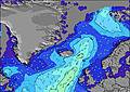 | 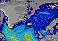 | 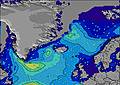 | 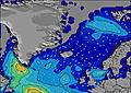 |  | 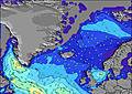 | 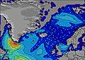 | 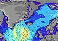 | 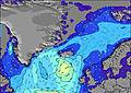 | |||||||||||||||
Onda Altezza (m) Direzione Periodo (s) | SW 10 | SW 11 | SW 10 | WSW 10 | WSW 10 | SW 9 | WSW 9 | WSW 9 | WSW 8 | SW 8 | WSW 8 | SW 8 | SW 8 | SW 8 | W 7 | W 7 | W 7 | W 7 | W 7 | W 7 | WSW 8 | WSW 9 | WSW 9 | WSW 12 |
Grafico delle onde | ||||||||||||||||||||||||
2415 | 2534 | 2121 | 1420 | 1102 | 794 | 565 | 402 | 307 | 226 | 213 | 135 | 113 | 100 | 94 | 92 | 113 | 110 | 92 | 70 | 122 | 108 | 109 | 306 | |
Vento (km/h) | ||||||||||||||||||||||||
Stato del vento onshore cross-onshore cross-shore cross-offshore offshore piatto | cross-off | cross-off | off | off | off | cross-off | cross-off | cross-off | cross-off | cross-off | off | off | off | off | off | off | off | off | off | cross-off | cross-off | off | off | off |
Alta Marea | 6:45PM3.26m | 7:05AM2.81m | 7:30PM3.26m | 7:50AM2.80m | 8:14PM3.17m | 8:33AM2.73m | ||||||||||||||||||
Basso Marea | 12:22PM0.02m | 1:03AM0.05m | 1:08PM-0.03m | 1:48AM0.05m | 1:53PM0.00m | 2:30AM0.11m | ||||||||||||||||||
— | — | — | — | 3:44 | — | — | — | — | — | — | — | 3:47 | — | — | — | — | — | — | — | 3:49 | — | — | — | |
— | — | 11:17 | — | — | — | — | — | — | — | 11:15 | — | — | — | — | — | — | — | 11:13 | — | — | — | — | 11:09 | |
mm | — | — | — | — | — | — | — | — | — | — | — | — | — | — | — | — | — | — | — | — | — | — | 1 | — |
Temp. °C | 10 | 10 | 9 | 10 | 10 | 10 | 11 | 11 | 11 | 11 | 11 | 10 | 9 | 9 | 11 | 13 | 14 | 14 | 13 | 11 | 11 | 12 | 12 | 13 |
Gelo °C | 4 | 4 | 3 | 6 | 7 | 8 | 7 | 7 | 8 | 8 | 8 | 7 | 6 | 6 | 8 | 8 | 8 | 8 | 8 | 7 | 9 | 10 | 10 | 11 |
Onda 1 Altezza (m) Direzione Periodo (s) | S 18 | S 18 | SSW 16 | WSW 10 | WSW 10 | SW 9 | WSW 9 | WSW 9 | WSW 8 | SW 8 | S 14 | SW 8 | SW 8 | W 7 | SW 8 | SW 8 | SW 8 | SW 8 | SW 8 | SW 9 | WSW 8 | WSW 9 | WSW 9 | WSW 12 |
25 | 25 | 446 | 1420 | 1102 | 794 | 565 | 402 | 307 | 226 | 100 | 135 | 113 | 100 | 71 | 59 | 48 | 28 | 28 | 61 | 122 | 108 | 108 | 306 | |
Onda 2 Altezza (m) Direzione Periodo (s) | — | — | S 18 | S 17 | S 16 | S 16 | SSW 16 | SSW 16 | S 16 | SSW 14 | SSW 12 | SW 14 | W 7 | SW 8 | S 15 | S 15 | S 15 | S 15 | WSW 9 | S 14 | SSW 14 | WSW 12 | WSW 12 | S 13 |
— | — | 25 | 23 | 46 | 45 | 50 | 50 | 45 | 76 | 27 | 49 | 82 | 84 | 38 | 38 | 38 | 38 | 16 | 37 | 39 | 85 | 109 | 32 | |
Onda 3 Altezza (m) Direzione Periodo (s) | — | — | — | — | — | — | — | — | S 11 | S 14 | S 16 | S 14 | S 16 | S 15 | S 11 | — | S 7 | — | S 14 | WSW 14 | SW 13 | S 14 | S 14 | S 7 |
— | — | — | — | — | — | — | — | 2 | 16 | 20 | 16 | 43 | 38 | 2 | — | 1 | — | 37 | 19 | 46 | 36 | 34 | 1 | |
onde vento Altezza (m) Direzione Periodo (s) | SW 10 | SW 11 | SW 10 | — | — | — | — | — | W 7 | — | WSW 8 | W 7 | — | — | W 7 | W 7 | W 7 | W 7 | W 7 | W 7 | — | WNW 6 | WNW 6 | WNW 5 |
2415 | 2534 | 2121 | — | — | — | — | — | 88 | — | 213 | 82 | — | — | 94 | 92 | 113 | 110 | 92 | 70 | — | 12 | 23 | 11 | |
Il più vicino Offshore or Glassy | ||||||||||||||||||||||||
Distanza (km) | 780 | 780 | 314 | 0 | 0 | 0 | 0 | 314 | 0 | 0 | 0 | 0 | 0 | 0 | 0 | 0 | 0 | 0 | 0 | 0 | 0 | 0 | 0 | 0 |
Migliori previsioni per le condizioni d'onda in Reykjanes Peninsula | ||||||||||||||||||||||||
Migliori previsioni per le condizioni d'onda in Iceland | ||||||||||||||||||||||||
Trova Onde Globale | ||||||||||||||||||||||||
- Map Icons:
 Break
Break Live Wave Height (m)
 Live Wind Speed (km/h)
 Surf Rating (10 Max)
 Ocean Swells (m)
- Wind Speed (km/h)
Widget Free Surf-Forecast.com per il tuo sito
La relazione di surf / widget meteo è disponibile qui sotto per incorporare su siti esterni a titolo gratuito e fornisce una sintesi delle nostre Þorlákshöfn or Porlackshofn previsione surf. Basta prendere il frammento di codice html da noi fornito e copiarlo nel proprio sito. È possibile scegliere la lingua preferita e unità metriche / imperiali per il feed delle previsioni surf per soddisfare le esigenze degli utenti del vostro sito .... Clicca qui per ottenere il codice.
 Nearest