
Previsioni:

Previsione a breve termineper lo più asciutto. Very mild (Max 18°C Sabato pomeriggio, Min 14°C Venerdì mattina). Vento sarà generalmente leggero. | ||||||||||||||||||||||||
Mer 15 | Giovedì 16 | Venerdì 17 | 18 | |||||||||||||||||||||
5 PM | 8 PM | 11 PM | 2 AM | 5 AM | 8 AM | 11 AM | 2 PM | 5 PM | 8 PM | 11 PM | 2 AM | 5 AM | 8 AM | 11 AM | 2 PM | 5 PM | 8 PM | 11 PM | 2 AM | 5 AM | 8 AM | 11 AM | 2 PM | |
Mappa dell'altezza del moto ondoso |  |  |  |  |  |  |  |  | 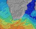 | |||||||||||||||
Onda Altezza (m) Direzione Periodo (s) | E 10 | SW 10 | SW 10 | SSW 16 | SSW 15 | SSW 14 | SSW 14 | SSW 14 | SSW 14 | SSW 14 | SSW 13 | SSW 13 | SSW 13 | SSW 13 | SSW 12 | SSW 12 | SSW 12 | SSW 11 | SSW 11 | SSW 11 | S 12 | S 12 | S 12 | S 10 |
Grafico delle onde | ||||||||||||||||||||||||
192 | 1470 | 1347 | 321 | 519 | 1191 | 1127 | 1111 | 999 | 802 | 680 | 581 | 649 | 799 | 830 | 710 | 585 | 411 | 359 | 305 | 301 | 235 | 376 | 367 | |
Vento (km/h) | ||||||||||||||||||||||||
Stato del vento onshore cross-onshore cross-shore cross-offshore offshore piatto | off | off | off | off | cross-off | cross-off | cross-off | cross-off | off | off | cross-off | off | off | cross-off | cross-off | glassy | cross | cross-on | glassy | glassy | cross-off | cross-off | off | off |
Alta Marea | 4:36PM1.88m | 4:49AM1.85m | 5:18PM1.90m | 5:31AM1.80m | 5:59PM1.88m | 6:11AM1.71m | ||||||||||||||||||
Basso Marea | 10:42PM0.30m | 10:58AM0.20m | 11:24PM0.32m | 11:36AM0.23m | 00:05AM0.37m | 12:13PM0.30m | ||||||||||||||||||
— | — | — | — | 7:20 | — | — | — | — | — | — | — | 7:18 | — | — | — | — | — | — | — | 7:18 | — | — | — | |
5:25 | — | — | — | — | — | — | — | 5:25 | — | — | — | — | — | — | — | 5:27 | — | — | — | — | — | — | 5:28 | |
mm | — | — | — | — | — | — | — | — | — | — | — | — | — | — | — | — | — | — | — | — | — | — | — | — |
Temp. °C | 17 | 16 | 16 | 15 | 15 | 15 | 16 | 17 | 16 | 16 | 16 | 15 | 15 | 14 | 16 | 16 | 16 | 16 | 15 | 15 | 15 | 15 | 17 | 18 |
Gelo °C | 13 | 12 | 13 | 12 | 13 | 14 | 15 | 16 | 15 | 15 | 15 | 13 | 13 | 12 | 15 | 16 | 15 | 16 | 15 | 15 | 14 | 14 | 15 | 16 |
Onda 1 Altezza (m) Direzione Periodo (s) | E 10 | SW 11 | SW 10 | SW 9 | SW 10 | SSW 14 | SSW 14 | SSW 14 | SSW 14 | SSW 14 | SSW 13 | SSW 13 | SSW 13 | SSW 13 | SSW 12 | SSW 12 | SSW 12 | SSW 11 | SSW 11 | SSW 11 | S 12 | S 12 | S 12 | S 10 |
192 | 548 | 469 | 321 | 322 | 1191 | 1127 | 1111 | 999 | 802 | 680 | 581 | 649 | 799 | 830 | 710 | 585 | 411 | 359 | 305 | 301 | 235 | 376 | 367 | |
Onda 2 Altezza (m) Direzione Periodo (s) | SSW 12 | E 10 | E 10 | E 10 | SSW 15 | E 10 | E 11 | E 11 | E 11 | E 11 | E 11 | E 10 | E 10 | E 10 | E 10 | E 10 | E 10 | E 10 | E 10 | E 10 | SW 11 | SW 10 | SW 10 | E 10 |
29 | 159 | 128 | 128 | 519 | 138 | 146 | 146 | 146 | 144 | 141 | 138 | 102 | 98 | 98 | 98 | 71 | 72 | 71 | 71 | 159 | 98 | 61 | 69 | |
Onda 3 Altezza (m) Direzione Periodo (s) | SSW 17 | SSW 17 | SSW 17 | SSW 16 | E 10 | SE 8 | SE 11 | SE 11 | S 11 | — | S 10 | — | — | — | — | — | S 14 | S 14 | S 14 | S 14 | E 10 | S 8 | E 10 | S 16 |
27 | 59 | 166 | 291 | 131 | 3 | 5 | 5 | 2 | — | 2 | — | — | — | — | — | 35 | 33 | 61 | 129 | 71 | 63 | 69 | 5 | |
onde vento Altezza (m) Direzione Periodo (s) | SW 8 | SW 10 | SW 10 | — | — | — | — | — | — | — | — | — | — | — | — | — | — | — | — | — | — | — | — | — |
187 | 1470 | 1347 | — | — | — | — | — | — | — | — | — | — | — | — | — | — | — | — | — | — | — | — | — | |
Il più vicino Offshore or Glassy | ||||||||||||||||||||||||
Distanza (km) | 7 | 0 | 0 | 0 | 1 | 0 | 0 | 0 | 0 | 0 | 0 | 0 | 0 | 0 | 0 | 0 | 1 | 7 | 0 | 0 | 0 | 0 | 0 | 0 |
Migliori previsioni per le condizioni d'onda in Eastern Cape (South) | ||||||||||||||||||||||||
Migliori previsioni per le condizioni d'onda in South Africa | ||||||||||||||||||||||||
Trova Onde Globale | ||||||||||||||||||||||||
- Map Icons:
 Break
Break Live Wave Height (m)
 Live Wind Speed (km/h)
 Surf Rating (10 Max)
 Ocean Swells (m)
- Wind Speed (km/h)
Widget Free Surf-Forecast.com per il tuo sito
La relazione di surf / widget meteo è disponibile qui sotto per incorporare su siti esterni a titolo gratuito e fornisce una sintesi delle nostre King's Beach (Port Elizabeth) previsione surf. Basta prendere il frammento di codice html da noi fornito e copiarlo nel proprio sito. È possibile scegliere la lingua preferita e unità metriche / imperiali per il feed delle previsioni surf per soddisfare le esigenze degli utenti del vostro sito .... Clicca qui per ottenere il codice.
 Nearest