
Previsioni:

Previsione a breve terminepioggia leggera (Totale 3mm), per lo più che cade mercoledì notte. Warm (Max 29°C mercoledì pomeriggio, Min 27°C mercoledì notte). Principalmente venti freschi. | ||||||||||||||||||||||||
Mercoledì 15 | Giovedì 16 | Venerdì 17 | 18 | |||||||||||||||||||||
4 AM | 7 AM | 10 AM | 1 PM | 4 PM | 7 PM | 10 PM | 1 AM | 4 AM | 7 AM | 10 AM | 1 PM | 4 PM | 7 PM | 10 PM | 1 AM | 4 AM | 7 AM | 10 AM | 1 PM | 4 PM | 7 PM | 10 PM | 1 AM | |
Mappa dell'altezza del moto ondoso | 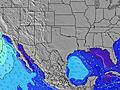 | 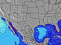 | 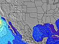 | 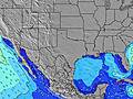 | 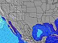 | 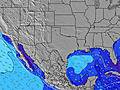 | 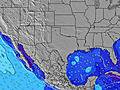 | 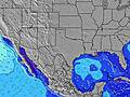 | 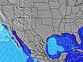 | 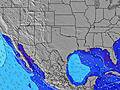 | ||||||||||||||
Onda Altezza (m) Direzione Periodo (s) | SE 5 | SE 5 | SE 5 | SE 6 | SE 6 | SE 6 | SE 6 | SE 6 | SE 6 | SE 6 | SE 6 | SE 6 | SE 6 | SE 6 | SE 6 | SE 6 | ESE 6 | ESE 7 | ESE 7 | ESE 7 | ESE 7 | ESE 6 | ESE 6 | ESE 6 |
Grafico delle onde | ||||||||||||||||||||||||
58 | 68 | 73 | 89 | 96 | 99 | 86 | 95 | 92 | 118 | 138 | 147 | 139 | 109 | 109 | 112 | 132 | 150 | 154 | 120 | 116 | 113 | 100 | 109 | |
Vento (km/h) | ||||||||||||||||||||||||
Stato del vento onshore cross-onshore cross-shore cross-offshore offshore piatto | cross-on | cross-on | cross-on | cross-on | cross-on | cross-on | cross-on | cross-on | cross-on | cross-on | cross-on | cross-on | cross-on | cross-on | cross-on | cross-on | cross-on | cross-on | cross-on | cross-on | cross-on | cross-on | cross-on | cross-on |
Alta Marea | 8:09AM0.42m | 8:24AM0.38m | 2:06PM0.34m | 8:24AM0.33m | 4:26PM0.30m | |||||||||||||||||||
Basso Marea | 10:59PM-0.20m | 12:53PM0.30m | 11:48PM-0.12m | 12:57PM0.23m | 00:34AM-0.03m | |||||||||||||||||||
6:45 | — | — | — | — | — | — | — | 6:46 | — | — | — | — | — | — | — | 6:46 | — | — | — | — | — | — | 6:47 | |
— | — | — | — | — | 8:22 | — | — | — | — | — | — | — | 8:22 | — | — | — | — | — | — | — | 8:22 | — | 8:22 | |
mm | — | — | — | — | — | — | — | — | 1 | — | — | 1 | — | — | — | — | — | — | — | 1 | — | — | — | — |
Temp. °C | 27 | 27 | 28 | 28 | 29 | 28 | 27 | 27 | 27 | 27 | 28 | 28 | 29 | 28 | 27 | 27 | 27 | 27 | 28 | 29 | 29 | 28 | 27 | 27 |
Gelo °C | 28 | 29 | 29 | 27 | 30 | 29 | 28 | 28 | 28 | 27 | 28 | 27 | 29 | 29 | 28 | 28 | 28 | 29 | 29 | 28 | 29 | 28 | 28 | 29 |
Onda 1 Altezza (m) Direzione Periodo (s) | ESE 9 | ESE 9 | ESE 9 | E 9 | E 10 | E 9 | E 9 | E 10 | — | — | — | — | — | — | — | — | — | — | — | — | — | — | — | E 10 |
8 | 8 | 8 | 6 | 2 | 2 | 2 | 2 | — | — | — | — | — | — | — | — | — | — | — | — | — | — | — | 2 | |
Onda 2 Altezza (m) Direzione Periodo (s) | — | — | — | — | — | — | — | — | — | — | — | — | — | — | — | — | — | — | — | — | — | — | — | — |
— | — | — | — | — | — | — | — | — | — | — | — | — | — | — | — | — | — | — | — | — | — | — | — | |
Onda 3 Altezza (m) Direzione Periodo (s) | — | — | — | — | — | — | — | — | — | — | — | — | — | — | — | — | — | — | — | — | — | — | — | — |
— | — | — | — | — | — | — | — | — | — | — | — | — | — | — | — | — | — | — | — | — | — | — | — | |
onde vento Altezza (m) Direzione Periodo (s) | SE 5 | SE 5 | SE 5 | SE 6 | SE 6 | SE 6 | SE 6 | SE 6 | SE 6 | SE 6 | SE 6 | SE 6 | SE 6 | SE 6 | SE 6 | SE 6 | ESE 6 | ESE 7 | ESE 7 | ESE 7 | ESE 7 | ESE 6 | ESE 6 | ESE 6 |
58 | 68 | 73 | 89 | 96 | 99 | 86 | 95 | 92 | 118 | 138 | 147 | 139 | 109 | 109 | 112 | 132 | 150 | 154 | 120 | 116 | 113 | 100 | 109 | |
Il più vicino Offshore or Glassy | ||||||||||||||||||||||||
Distanza (km) | 957 | 957 | 957 | 1035 | 1039 | 1026 | 971 | 957 | 957 | 957 | 957 | 1035 | 1035 | 1035 | 971 | 957 | 957 | 957 | 957 | 970 | 1027 | 978 | 957 | 957 |
Migliori previsioni per le condizioni d'onda in Texas | ||||||||||||||||||||||||
Migliori previsioni per le condizioni d'onda in United States | ||||||||||||||||||||||||
Trova Onde Globale | ||||||||||||||||||||||||
- Map Icons:
 Break
Break Live Wave Height (m)
 Live Wind Speed (km/h)
 Surf Rating (10 Max)
 Ocean Swells (m)
- Wind Speed (km/h)
Widget Free Surf-Forecast.com per il tuo sito
La relazione di surf / widget meteo è disponibile qui sotto per incorporare su siti esterni a titolo gratuito e fornisce una sintesi delle nostre Port Isabel previsione surf. Basta prendere il frammento di codice html da noi fornito e copiarlo nel proprio sito. È possibile scegliere la lingua preferita e unità metriche / imperiali per il feed delle previsioni surf per soddisfare le esigenze degli utenti del vostro sito .... Clicca qui per ottenere il codice.
 Nearest