
Previsioni:

Previsione a breve termineper lo più asciutto. Warm (Max 24°C Sabato mattina, Min 20°C Sabato notte). Vento sarà generalmente leggero. | ||||||||||||||||||||||||
Giovedì 16 | Venerdì 17 | Sabato 18 | ||||||||||||||||||||||
2 AM | 5 AM | 8 AM | 11 AM | 2 PM | 5 PM | 8 PM | 11 PM | 2 AM | 5 AM | 8 AM | 11 AM | 2 PM | 5 PM | 8 PM | 11 PM | 2 AM | 5 AM | 8 AM | 11 AM | 2 PM | 5 PM | 8 PM | 11 PM | |
Mappa dell'altezza del moto ondoso |  |  |  |  |  |  |  |  | 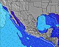 | |||||||||||||||
Onda Altezza (m) Direzione Periodo (s) | SW 16 | SW 16 | SW 16 | SW 16 | SW 16 | SW 15 | SW 15 | SW 15 | SW 19 | SW 19 | SW 19 | SW 19 | SW 18 | SW 14 | WNW 19 | WNW 18 | SW 17 | SW 18 | SW 18 | SW 17 | SW 16 | SSW 16 | SW 16 | SSW 16 |
Grafico delle onde | ||||||||||||||||||||||||
125 | 124 | 124 | 122 | 119 | 109 | 106 | 134 | 181 | 130 | 129 | 102 | 82 | 102 | 118 | 108 | 190 | 192 | 246 | 354 | 386 | 447 | 264 | 649 | |
Vento (km/h) | ||||||||||||||||||||||||
Stato del vento onshore cross-onshore cross-shore cross-offshore offshore piatto | cross-on | glassy | glassy | on | cross-on | cross-on | cross | cross-on | cross-on | glassy | glassy | on | cross-on | cross-on | cross | cross | cross-on | cross | cross | cross-on | cross-on | cross-on | cross | cross |
Alta Marea | 11:38AM1.93m | 10:54PM2.43m | 12:17PM1.96m | 11:40PM2.18m | 12:56PM1.99m | |||||||||||||||||||
Basso Marea | 5:11AM0.04m | 4:48PM0.99m | 5:48AM0.23m | 5:43PM1.01m | 6:22AM0.44m | 6:45PM1.03m | ||||||||||||||||||
— | 5:48 | — | — | — | — | — | — | — | 5:50 | — | — | — | — | — | — | — | 5:50 | — | — | — | — | — | — | |
— | — | — | — | — | 7:36 | — | — | — | — | — | — | — | 7:36 | — | — | — | — | — | — | — | 7:36 | — | — | |
mm | — | — | — | — | — | — | — | — | — | — | — | — | — | — | — | — | — | — | — | — | — | — | — | — |
Temp. °C | 19 | 19 | 21 | 22 | 23 | 23 | 21 | 21 | 21 | 21 | 22 | 23 | 23 | 23 | 22 | 22 | 22 | 22 | 23 | 24 | 24 | 23 | 22 | 22 |
Gelo °C | 20 | 21 | 23 | 22 | 22 | 22 | 21 | 21 | 22 | 22 | 23 | 23 | 22 | 22 | 21 | 22 | 22 | 22 | 23 | 23 | 23 | 22 | 21 | 22 |
Onda 1 Altezza (m) Direzione Periodo (s) | SW 16 | SW 16 | SW 16 | SW 16 | SW 16 | SW 15 | SW 15 | SW 15 | SW 19 | NW 9 | WNW 9 | WNW 9 | WNW 9 | WNW 9 | WNW 9 | WNW 9 | WNW 9 | WNW 9 | SW 18 | SW 17 | SW 16 | SSW 16 | SSW 13 | SSW 16 |
125 | 124 | 124 | 122 | 119 | 109 | 106 | 134 | 181 | 37 | 53 | 53 | 53 | 52 | 52 | 50 | 50 | 52 | 246 | 354 | 386 | 447 | 195 | 649 | |
Onda 2 Altezza (m) Direzione Periodo (s) | WNW 5 | WNW 5 | WNW 5 | WNW 5 | NW 8 | NW 8 | NW 8 | WNW 8 | SW 14 | SW 14 | SW 14 | SW 14 | SW 14 | SW 14 | SW 14 | SW 14 | SW 17 | SW 18 | WNW 9 | WNW 9 | WNW 9 | NW 9 | SW 16 | WNW 8 |
5 | 5 | 5 | 5 | 17 | 17 | 16 | 24 | 103 | 103 | 103 | 102 | 73 | 102 | 72 | 71 | 190 | 192 | 52 | 52 | 50 | 37 | 264 | 47 | |
Onda 3 Altezza (m) Direzione Periodo (s) | SW 21 | WNW 8 | WNW 8 | WNW 8 | W 20 | W 20 | W 20 | SW 19 | WNW 8 | SW 19 | SW 19 | SW 19 | SW 18 | WNW 19 | WNW 19 | WNW 18 | WNW 18 | WSW 13 | SW 13 | WNW 17 | WNW 17 | W 17 | WNW 9 | W 16 |
71 | 7 | 7 | 7 | 33 | 33 | 32 | 94 | 26 | 130 | 129 | 90 | 82 | 71 | 118 | 108 | 107 | 70 | 85 | 101 | 101 | 153 | 49 | 137 | |
onde vento Altezza (m) Direzione Periodo (s) | — | — | — | — | WNW 5 | WNW 5 | — | — | — | — | — | — | — | — | — | — | — | — | — | — | — | WNW 2 | — | NW 3 |
— | — | — | — | 5 | 6 | — | — | — | — | — | — | — | — | — | — | — | — | — | — | — | 1 | — | 1 | |
Il più vicino Offshore or Glassy | ||||||||||||||||||||||||
Distanza (km) | 157 | 157 | 180 | 655 | 327 | 655 | 157 | 157 | 327 | 180 | 202 | 327 | 327 | 476 | 157 | 157 | 157 | 157 | 157 | 327 | 688 | 523 | 379 | 224 |
Migliori previsioni per le condizioni d'onda in Baja Norte | ||||||||||||||||||||||||
Migliori previsioni per le condizioni d'onda in Mexico | ||||||||||||||||||||||||
Trova Onde Globale | ||||||||||||||||||||||||
- Map Icons:
 Break
Break Live Wave Height (m)
 Live Wind Speed (km/h)
 Surf Rating (10 Max)
 Ocean Swells (m)
- Wind Speed (km/h)
Widget Free Surf-Forecast.com per il tuo sito
La relazione di surf / widget meteo è disponibile qui sotto per incorporare su siti esterni a titolo gratuito e fornisce una sintesi delle nostre Puerto San Andres previsione surf. Basta prendere il frammento di codice html da noi fornito e copiarlo nel proprio sito. È possibile scegliere la lingua preferita e unità metriche / imperiali per il feed delle previsioni surf per soddisfare le esigenze degli utenti del vostro sito .... Clicca qui per ottenere il codice.
 Nearest