
Previsioni:

Aggiornamento in hr min s Forecast update imminent
Previsione a breve termineper lo più asciutto. Warm (Max 22°C Venerdì mattina, Min 16°C mercoledì notte). Vento sarà generalmente leggero. | ||||||||||||||||||||||||
Mercoledì 1 | Giovedì 2 | Venerdì 3 | ||||||||||||||||||||||
2 AM | 5 AM | 8 AM | 11 AM | 2 PM | 5 PM | 8 PM | 11 PM | 2 AM | 5 AM | 8 AM | 11 AM | 2 PM | 5 PM | 8 PM | 11 PM | 2 AM | 5 AM | 8 AM | 11 AM | 2 PM | 5 PM | 8 PM | 11 PM | |
Mappa dell'altezza del moto ondoso |  | 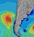 |  |  | 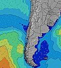 |  |  | 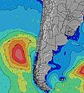 |  | |||||||||||||||
Onda Altezza (m) Direzione Periodo (s) | SSW 16 | SW 16 | SW 16 | SW 15 | SW 15 | SW 15 | SW 15 | SW 15 | SW 15 | SW 15 | SW 14 | SW 14 | SSW 14 | SSW 14 | SSW 14 | SSW 14 | SSW 14 | SSW 14 | SSW 14 | SW 14 | SSW 14 | SSW 13 | SSW 13 | SSW 13 |
Grafico delle onde | ||||||||||||||||||||||||
2032 | 1224 | 1284 | 1219 | 1088 | 1271 | 1074 | 1118 | 1163 | 1074 | 1016 | 834 | 1126 | 961 | 961 | 701 | 701 | 691 | 774 | 811 | 1126 | 1061 | 1030 | 918 | |
Vento (km/h) | ||||||||||||||||||||||||
Stato del vento onshore cross-onshore cross-shore cross-offshore offshore piatto | glassy | glassy | glassy | on | on | cross-on | cross-on | cross-on | cross-on | cross-on | cross-on | cross-on | cross-on | cross-on | cross-on | cross-on | cross-on | cross-on | cross-on | cross-on | cross-on | cross-on | cross-on | glassy |
Alta Marea | 10:20AM1.40m | 10:45PM0.85m | 10:54AM1.38m | 11:24PM0.85m | 11:27AM1.34m | |||||||||||||||||||
Basso Marea | 3:28AM0.42m | 5:19PM0.38m | 4:03AM0.43m | 5:55PM0.38m | 4:39AM0.46m | 6:29PM0.39m | ||||||||||||||||||
— | 7:16 | — | — | — | — | — | — | — | 7:16 | — | — | — | — | — | — | — | 7:16 | — | — | — | — | — | — | |
— | — | — | — | — | 6:12 | — | — | — | — | — | — | — | 6:12 | — | — | — | — | — | — | — | 6:12 | — | — | |
mm | — | — | — | — | — | — | — | — | — | — | — | — | — | — | — | — | — | — | — | — | — | — | — | — |
Temp. °C | 15 | 16 | 17 | 18 | 19 | 18 | 17 | 16 | 17 | 17 | 18 | 20 | 20 | 18 | 19 | 17 | 18 | 18 | 17 | 22 | 20 | 19 | 18 | 17 |
Gelo °C | 15 | 16 | 17 | 17 | 18 | 17 | 16 | 16 | 16 | 16 | 17 | 18 | 18 | 17 | 18 | 17 | 17 | 17 | 16 | 20 | 19 | 18 | 18 | 18 |
Onda 1 Altezza (m) Direzione Periodo (s) | SSW 16 | SW 16 | SW 16 | SW 15 | SW 15 | SW 15 | SW 15 | SW 15 | SW 15 | SW 15 | SW 14 | SW 14 | SSW 14 | SSW 14 | SSW 14 | SSW 14 | SSW 14 | SSW 14 | SSW 14 | SW 14 | SSW 14 | SSW 13 | SSW 13 | SSW 13 |
2032 | 1224 | 1284 | 1219 | 1088 | 1271 | 1074 | 1118 | 1163 | 1074 | 1016 | 834 | 1126 | 961 | 961 | 701 | 701 | 691 | 774 | 811 | 1126 | 1061 | 1030 | 918 | |
Onda 2 Altezza (m) Direzione Periodo (s) | SW 11 | SSW 10 | SSW 10 | SSW 10 | SSW 10 | SSW 9 | SSW 9 | SSW 9 | SW 9 | SSW 8 | SSW 8 | — | — | SW 20 | SW 20 | SW 8 | SW 8 | SW 8 | SSW 7 | SW 7 | — | SW 26 | SW 26 | SW 26 |
328 | 294 | 200 | 168 | 168 | 101 | 103 | 101 | 79 | 61 | 43 | — | — | 60 | 60 | 65 | 65 | 64 | 66 | 75 | — | 26 | 26 | 26 | |
Onda 3 Altezza (m) Direzione Periodo (s) | — | SSW 20 | SSW 20 | — | — | — | — | — | SW 21 | SW 21 | SW 21 | — | — | — | — | — | — | — | — | — | — | — | — | SW 20 |
— | 37 | 37 | — | — | — | — | — | 18 | 18 | 18 | — | — | — | — | — | — | — | — | — | — | — | — | 15 | |
onde vento Altezza (m) Direzione Periodo (s) | — | — | — | — | — | — | — | — | — | — | — | SSW 8 | — | — | — | — | — | — | — | — | — | — | — | — |
— | — | — | — | — | — | — | — | — | — | — | 58 | — | — | — | — | — | — | — | — | — | — | — | — | |
Il più vicino Offshore or Glassy | ||||||||||||||||||||||||
Distanza (km) | 0 | 0 | 0 | 3 | 3 | 3 | 3 | 1 | 3 | 3 | 3 | 3 | 3 | 3 | 3 | 3 | 3 | 3 | 3 | 3 | 197 | 3 | 3 | 0 |
Migliori previsioni per le condizioni d'onda in Tarapaca | ||||||||||||||||||||||||
Migliori previsioni per le condizioni d'onda in Chile | ||||||||||||||||||||||||
Trova Onde Globale | ||||||||||||||||||||||||
- Map Icons:
 Break
Break Live Wave Height (m)
 Live Wind Speed (km/h)
 Surf Rating (10 Max)
 Ocean Swells (m)
- Wind Speed (km/h)
Widget Free Surf-Forecast.com per il tuo sito
La relazione di surf / widget meteo è disponibile qui sotto per incorporare su siti esterni a titolo gratuito e fornisce una sintesi delle nostre Punta Gruesa previsione surf. Basta prendere il frammento di codice html da noi fornito e copiarlo nel proprio sito. È possibile scegliere la lingua preferita e unità metriche / imperiali per il feed delle previsioni surf per soddisfare le esigenze degli utenti del vostro sito .... Clicca qui per ottenere il codice.
 Nearest