

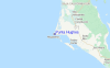
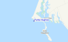
Punta Hughes Surf Guide
Punta Hughes in Baja Sur is an exposed point break that has reasonably consistent surf Offshore winds are from the northeast. Tends to receive distant groundswells and the best swell direction is from the southwest.. Rarely crowded here. Take care of rocks in the line up.
Punta Hughes Spot Info
| Type: | Rating: | Reliability: | Todays Sea Temp*: |
|---|---|---|---|
| fairly consistent | 25.9°C*ocean temperature recorded from satellite |
Surfing Punta Hughes:
The best conditions reported for surf at Punta Hughes occur when a Southwest swell combines with an offshore wind direction from the Northeast.
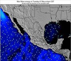
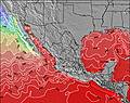
Previsioni Energia d'onda (Potenza): 12hrs


Punta Hughes Surf:
Sunday, 19 July 2026, 12:11 Local time| Domenica 19 | ||||
| 8AM | 11AM | 2PM | 5PM | |
| Wave (m) | ||||
| Periodo (s) | 17 | 17 | 17 | 16 |
| Vento (km/h) | ||||
| Stato del vento | cross | cross- on |
cross- on |
cross- on |
- /breaks/Punta-Hughes/forecasts/latest
Punta Hughes Surf Guide
Punta Hughes in Baja Sur is an exposed point break that has reasonably consistent surf Offshore winds are from the northeast. Tends to receive distant groundswells and the best swell direction is from the southwest.. Rarely crowded here. Take care of rocks in the line up.
Punta Hughes Spot Info
Type: Rating: Reliability: Todays Sea Temp*:  Point
Point 2
2fairly consistent 25.9°C*ocean temperature recorded from satelliteSurfing Punta Hughes:
The best conditions reported for surf at Punta Hughes occur when a Southwest swell combines with an offshore wind direction from the Northeast.
Previsioni Energia d'onda (Potenza): 12hrs
Utilizzare la scheda di navigazione in alto per visualizzare Punta Hughes temperatura del mare, Punta Hughes fotografie, Punta Hughes dettagliate previsioni onde, il vento e le previsioni meteo, Punta Hughes webcam, vento corrente da Baja Sur stazioni meteo e Punta Hughes previsioni marea. Il link Mexico mappe maree apre l'immagine grande, che mostra Mexico e dei mari circostanti. Queste mappe possono essere animate per mostrare le diverse componenti del moto ondoso, energia delle onde, periodo d'onda, altezza delle onde, insieme con le previsioni del vento e meteo, meteo corrente e osservazioni sullo stato del mare dal Mexico onda-boe, le navi passanti e stazioni meteo costiere. Ciascuna delle pagine di previsioni per questo surf break rappresenta uno strumento di wavefinder globale e regionale per individuare le migliori condizioni di surf nella zona intorno Punta Hughes.
Punta Hughes Surf:
Sunday, 19 July 2026, 12:11 Local timeDomenica 19 8AM 11AM 2PM 5PM Wave (m) Periodo (s) 17 17 17 16 Vento (km/h) Stato del vento cross cross-
oncross-
oncross-
on- /breaks/Punta-Hughes/forecasts/latest
- /breaks/Punta-Hughes/forecasts/latest/six_day
Punta Hughes Surf Guide
Punta Hughes in Baja Sur is an exposed point break that has reasonably consistent surf Offshore winds are from the northeast. Tends to receive distant groundswells and the best swell direction is from the southwest.. Rarely crowded here. Take care of rocks in the line up.
Punta Hughes Spot Info
Type: Rating: Reliability: Todays Sea Temp*: Point2fairly consistent 25.9°C*ocean temperature recorded from satelliteSurfing Punta Hughes:
The best conditions reported for surf at Punta Hughes occur when a Southwest swell combines with an offshore wind direction from the Northeast.
Previsioni Energia d'onda (Potenza): 12hrs
Utilizzare la scheda di navigazione in alto per visualizzare Punta Hughes temperatura del mare, Punta Hughes fotografie, Punta Hughes dettagliate previsioni onde, il vento e le previsioni meteo, Punta Hughes webcam, vento corrente da Baja Sur stazioni meteo e Punta Hughes previsioni marea. Il link Mexico mappe maree apre l'immagine grande, che mostra Mexico e dei mari circostanti. Queste mappe possono essere animate per mostrare le diverse componenti del moto ondoso, energia delle onde, periodo d'onda, altezza delle onde, insieme con le previsioni del vento e meteo, meteo corrente e osservazioni sullo stato del mare dal Mexico onda-boe, le navi passanti e stazioni meteo costiere. Ciascuna delle pagine di previsioni per questo surf break rappresenta uno strumento di wavefinder globale e regionale per individuare le migliori condizioni di surf nella zona intorno Punta Hughes.
Punta Hughes Surf:
Sunday, 19 July 2026, 12:11 Local timeDomenica 19 8AM 11AM 2PM 5PM Wave (m) Periodo (s) 17 17 17 16 Vento (km/h) Stato del vento cross cross-
oncross-
oncross-
on- /breaks/Punta-Hughes/forecasts/latest
Punta Hughes Surf Guide
Punta Hughes in Baja Sur is an exposed point break that has reasonably consistent surf Offshore winds are from the northeast. Tends to receive distant groundswells and the best swell direction is from the southwest.. Rarely crowded here. Take care of rocks in the line up.
Punta Hughes Spot Info
Type: Rating: Reliability: Todays Sea Temp*: Point2fairly consistent 25.9°C*ocean temperature recorded from satelliteSurfing Punta Hughes:
The best conditions reported for surf at Punta Hughes occur when a Southwest swell combines with an offshore wind direction from the Northeast.
Previsioni Energia d'onda (Potenza): 12hrs
Utilizzare la scheda di navigazione in alto per visualizzare Punta Hughes temperatura del mare, Punta Hughes fotografie, Punta Hughes dettagliate previsioni onde, il vento e le previsioni meteo, Punta Hughes webcam, vento corrente da Baja Sur stazioni meteo e Punta Hughes previsioni marea. Il link Mexico mappe maree apre l'immagine grande, che mostra Mexico e dei mari circostanti. Queste mappe possono essere animate per mostrare le diverse componenti del moto ondoso, energia delle onde, periodo d'onda, altezza delle onde, insieme con le previsioni del vento e meteo, meteo corrente e osservazioni sullo stato del mare dal Mexico onda-boe, le navi passanti e stazioni meteo costiere. Ciascuna delle pagine di previsioni per questo surf break rappresenta uno strumento di wavefinder globale e regionale per individuare le migliori condizioni di surf nella zona intorno Punta Hughes.
Punta Hughes Surf:
Sunday, 19 July 2026, 12:11 Local timeDomenica 19 8AM 11AM 2PM 5PM Wave (m) Periodo (s) 17 17 17 16 Vento (km/h) Stato del vento cross cross-
oncross-
oncross-
onTide Times:
A Punta Hughes (0 km).
PROSSIMA È ALLE (ora locale) rimanente alta marea bassa marea Punta Hughes Tide Times and Tide Chart
Live Weather:
At ASCATB248E24N, 133 km from Punta Hughes.
light winds from the NNE
(km/h)Air temperature
-°COverall Punta Hughes Surf Consistency and Wind Distribution in Luglio


Wind stats for Punta Hughes: see the variation in direction and stength by month.
foto dall' album
Contorni: Strade e fiumi: seleziona un surf break dal menu 


Utilizzare questa mappa sollievo per navigare Baja Sur surf breaks e stazioni di marea che si trovano nella zona diPunta Hughes
Altri surf breaks più vicini al Punta Hughes:
(clicca sul nome del luogo per maggiori informazioni)- Closest località surf61 mi
- Second closest località surf84 mi
- Third closest località surf91 mi
- Fourth closest località surf93 mi
- Fifth closest località surf103 mi
Onda boe più vicina a Punta Hughes:
- Closest Onda boa616 mi
- Second closest Onda boa621 mi
- Third closest Onda boa636 mi
- Fourth closest Onda boa636 mi
- Fifth closest Onda boa637 mi
Stazioni di marea più vicina alla Punta Hughes:
- Closest marea stazioneSan Carlos10 mi
- Second closest marea stazioneBahia Magdalena12 mi
- Third closest marea stazioneSan Juan de la Costa102 mi
- Fourth closest marea stazioneBahia San Juanico104 mi
- Fifth closest marea stazioneLoreto104 mi
Airports
- The nearest passenger airport to Punta Hughes is Loreto International Airport (LTO) in Mexico, which is 165 km (102 miles) away (directly).
- The second closest airport to Punta Hughes is General Manuel Marquez De Leon International (La Paz) Airport (LAP), also in Mexico, 208 km (129 miles) away.

- /breaks/Punta-Hughes/forecasts/latest


 Nearest