
Punta San Jacinto (Shipwrecks) Surf Guide
Punta San Jacinto (Shipwrecks) in Baja Norte is an exposed point break that has dependable surf. Winter is the best time of year for surfing here. Offshore winds blow from the northeast. Groundswells more frequent than windswells and the optimum swell angle is from the west. Best around high tide. It very rarely gets crowded here. Take care not to hit part of the wreck here.
Punta San Jacinto (Shipwrecks) Spot Info
| Type: | Rating: | Reliability: | Todays Sea Temp*: |
|---|---|---|---|
| consistent | 19.1°C*ocean temperature recorded from satellite |
Surfing Punta San Jacinto (Shipwrecks):
The best conditions reported for surf at Punta San Jacinto (Shipwrecks) occur when a West swell combines with an offshore wind direction from the Northeast.
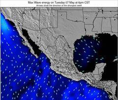
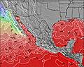
Previsioni Energia d'onda (Potenza): 12hrs


Punta San Jacinto (Shipwrecks) Surf:
Friday, 17 July 2026, 10:18 Local time| Venerdì 17 | ||||
| 8AM | 11AM | 2PM | 5PM | |
| Wave (m) | ||||
| Periodo (s) | 19 | 8 | 9 | 9 |
| Vento (km/h) | ||||
| Stato del vento | cross- on |
on | on | on |
- /breaks/Punta-San-Jacinto/forecasts/latest
Punta San Jacinto (Shipwrecks) Surf Guide
Punta San Jacinto (Shipwrecks) in Baja Norte is an exposed point break that has dependable surf. Winter is the best time of year for surfing here. Offshore winds blow from the northeast. Groundswells more frequent than windswells and the optimum swell angle is from the west. Best around high tide. It very rarely gets crowded here. Take care not to hit part of the wreck here.
Punta San Jacinto (Shipwrecks) Spot Info
Type: Rating: Reliability: Todays Sea Temp*:  Point
Point 2
2consistent 19.1°C*ocean temperature recorded from satelliteSurfing Punta San Jacinto (Shipwrecks):
The best conditions reported for surf at Punta San Jacinto (Shipwrecks) occur when a West swell combines with an offshore wind direction from the Northeast.
Previsioni Energia d'onda (Potenza): 12hrs
Utilizzare la scheda di navigazione in alto per visualizzare Punta San Jacinto (Shipwrecks) temperatura del mare, Punta San Jacinto (Shipwrecks) fotografie, Punta San Jacinto (Shipwrecks) dettagliate previsioni onde, il vento e le previsioni meteo, Punta San Jacinto (Shipwrecks) webcam, vento corrente da Baja Norte stazioni meteo e Punta San Jacinto (Shipwrecks) previsioni marea. Il link Mexico mappe maree apre l'immagine grande, che mostra Mexico e dei mari circostanti. Queste mappe possono essere animate per mostrare le diverse componenti del moto ondoso, energia delle onde, periodo d'onda, altezza delle onde, insieme con le previsioni del vento e meteo, meteo corrente e osservazioni sullo stato del mare dal Mexico onda-boe, le navi passanti e stazioni meteo costiere. Ciascuna delle pagine di previsioni per questo surf break rappresenta uno strumento di wavefinder globale e regionale per individuare le migliori condizioni di surf nella zona intorno Punta San Jacinto (Shipwrecks).
Punta San Jacinto (Shipwrecks) Surf:
Friday, 17 July 2026, 10:18 Local timeVenerdì 17 8AM 11AM 2PM 5PM Wave (m) Periodo (s) 19 8 9 9 Vento (km/h) Stato del vento cross-
onon on on - /breaks/Punta-San-Jacinto/forecasts/latest
- /breaks/Punta-San-Jacinto/forecasts/latest/six_day
Punta San Jacinto (Shipwrecks) Surf Guide
Punta San Jacinto (Shipwrecks) in Baja Norte is an exposed point break that has dependable surf. Winter is the best time of year for surfing here. Offshore winds blow from the northeast. Groundswells more frequent than windswells and the optimum swell angle is from the west. Best around high tide. It very rarely gets crowded here. Take care not to hit part of the wreck here.
Punta San Jacinto (Shipwrecks) Spot Info
Type: Rating: Reliability: Todays Sea Temp*: Point2consistent 19.1°C*ocean temperature recorded from satelliteSurfing Punta San Jacinto (Shipwrecks):
The best conditions reported for surf at Punta San Jacinto (Shipwrecks) occur when a West swell combines with an offshore wind direction from the Northeast.
Previsioni Energia d'onda (Potenza): 12hrs
Utilizzare la scheda di navigazione in alto per visualizzare Punta San Jacinto (Shipwrecks) temperatura del mare, Punta San Jacinto (Shipwrecks) fotografie, Punta San Jacinto (Shipwrecks) dettagliate previsioni onde, il vento e le previsioni meteo, Punta San Jacinto (Shipwrecks) webcam, vento corrente da Baja Norte stazioni meteo e Punta San Jacinto (Shipwrecks) previsioni marea. Il link Mexico mappe maree apre l'immagine grande, che mostra Mexico e dei mari circostanti. Queste mappe possono essere animate per mostrare le diverse componenti del moto ondoso, energia delle onde, periodo d'onda, altezza delle onde, insieme con le previsioni del vento e meteo, meteo corrente e osservazioni sullo stato del mare dal Mexico onda-boe, le navi passanti e stazioni meteo costiere. Ciascuna delle pagine di previsioni per questo surf break rappresenta uno strumento di wavefinder globale e regionale per individuare le migliori condizioni di surf nella zona intorno Punta San Jacinto (Shipwrecks).
Punta San Jacinto (Shipwrecks) Surf:
Friday, 17 July 2026, 10:18 Local timeVenerdì 17 8AM 11AM 2PM 5PM Wave (m) Periodo (s) 19 8 9 9 Vento (km/h) Stato del vento cross-
onon on on - /breaks/Punta-San-Jacinto/forecasts/latest
Punta San Jacinto (Shipwrecks) Surf Guide
Punta San Jacinto (Shipwrecks) in Baja Norte is an exposed point break that has dependable surf. Winter is the best time of year for surfing here. Offshore winds blow from the northeast. Groundswells more frequent than windswells and the optimum swell angle is from the west. Best around high tide. It very rarely gets crowded here. Take care not to hit part of the wreck here.
Punta San Jacinto (Shipwrecks) Spot Info
Type: Rating: Reliability: Todays Sea Temp*: Point2consistent 19.1°C*ocean temperature recorded from satelliteSurfing Punta San Jacinto (Shipwrecks):
The best conditions reported for surf at Punta San Jacinto (Shipwrecks) occur when a West swell combines with an offshore wind direction from the Northeast.
Previsioni Energia d'onda (Potenza): 12hrs
Utilizzare la scheda di navigazione in alto per visualizzare Punta San Jacinto (Shipwrecks) temperatura del mare, Punta San Jacinto (Shipwrecks) fotografie, Punta San Jacinto (Shipwrecks) dettagliate previsioni onde, il vento e le previsioni meteo, Punta San Jacinto (Shipwrecks) webcam, vento corrente da Baja Norte stazioni meteo e Punta San Jacinto (Shipwrecks) previsioni marea. Il link Mexico mappe maree apre l'immagine grande, che mostra Mexico e dei mari circostanti. Queste mappe possono essere animate per mostrare le diverse componenti del moto ondoso, energia delle onde, periodo d'onda, altezza delle onde, insieme con le previsioni del vento e meteo, meteo corrente e osservazioni sullo stato del mare dal Mexico onda-boe, le navi passanti e stazioni meteo costiere. Ciascuna delle pagine di previsioni per questo surf break rappresenta uno strumento di wavefinder globale e regionale per individuare le migliori condizioni di surf nella zona intorno Punta San Jacinto (Shipwrecks).
Punta San Jacinto (Shipwrecks) Surf:
Friday, 17 July 2026, 10:18 Local timeVenerdì 17 8AM 11AM 2PM 5PM Wave (m) Periodo (s) 19 8 9 9 Vento (km/h) Stato del vento cross-
onon on on Tide Times:
Per Camalu, %{dist} %{km} da %{location}.
PROSSIMA È ALLE (ora locale) rimanente alta marea bassa marea Punta San Jacinto (Shipwrecks) Tide Times and Tide Chart
Live Weather:
At Tijuana International Airport, 203 km from Punta San Jacinto (Shipwrecks).
calm
(km/h)
Dry and partly cloudyAir temperature
23°COverall Punta San Jacinto (Shipwrecks) Surf Consistency and Wind Distribution in Luglio


Surf stats for Punta San Jacinto (Shipwrecks): see the swell variation by month.

Wind stats for Punta San Jacinto (Shipwrecks): see the variation in direction and stength by month.
foto dall' album
Contorni: Strade e fiumi: seleziona un surf break dal menu 


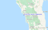
Utilizzare questa mappa sollievo per navigare Baja Norte surf breaks e stazioni di marea che si trovano nella zona diPunta San Jacinto (Shipwrecks)
Altri surf breaks più vicini al Punta San Jacinto (Shipwrecks):
(clicca sul nome del luogo per maggiori informazioni)- Closest località surf1 mi
- Second closest località surf1 mi
- Third closest località surf2 mi
- Fourth closest località surf2 mi
- Fifth closest località surf9 mi
Onda boe più vicina a Punta San Jacinto (Shipwrecks):
- Closest Onda boa134 mi
- Second closest Onda boa139 mi
- Third closest Onda boa154 mi
- Fourth closest Onda boa155 mi
- Fifth closest Onda boa155 mi
Stazioni di marea più vicina alla Punta San Jacinto (Shipwrecks):
- Closest marea stazioneCamalu4 mi
- Second closest marea stazioneSan Quintin27 mi
- Third closest marea stazioneEnsenada76 mi
- Fourth closest marea stazioneSan Felipe76 mi
- Fifth closest marea stazioneEl Sauzal80 mi
Airports
- The nearest passenger airport to Punta San Jacinto (Shipwrecks) is General Alberto L Salinas C International (Ensenada) Airport (ESE) in Mexico, which is 115 km (71 miles) away (directly).
- The second closest airport to Punta San Jacinto (Shipwrecks) is General Abelardo L Rodriguez International (Tijuana) Airport (TIJ), also in Mexico, 205 km (127 miles) away.
- /breaks/Punta-San-Jacinto/forecasts/latest

 Nearest