
Previsioni:

Previsione a breve termineper lo più asciutto. Warm (Max 22°C Venerdì mattina, Min 20°C mercoledì mattina). Principalmente venti freschi. | |||||||||||||||||||||
Mer 29 | Giovedì 30 | Venerdì 31 | |||||||||||||||||||
10 AM | 1 PM | 4 PM | 7 PM | 10 PM | 1 AM | 4 AM | 7 AM | 10 AM | 1 PM | 4 PM | 7 PM | 10 PM | 1 AM | 4 AM | 7 AM | 10 AM | 1 PM | 4 PM | 7 PM | 10 PM | |
Mappa dell'altezza del moto ondoso |  |  |  | 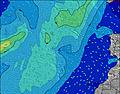 |  |  | 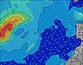 | 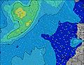 | |||||||||||||
Onda Altezza (m) Direzione Periodo (s) | NNW 10 | NNW 10 | NNW 10 | NNE 6 | NNE 6 | NNE 7 | NNE 7 | NNE 7 | NNE 7 | NNE 7 | NNE 7 | NNE 7 | NNE 7 | NNE 7 | NNE 7 | NNE 7 | NNE 7 | NNE 7 | NNE 7 | NNE 7 | NNE 7 |
Grafico delle onde | |||||||||||||||||||||
34 | 31 | 37 | 167 | 195 | 249 | 306 | 339 | 359 | 376 | 359 | 349 | 362 | 339 | 359 | 334 | 344 | 344 | 327 | 327 | 319 | |
Vento (km/h) | |||||||||||||||||||||
Stato del vento onshore cross-onshore cross-shore cross-offshore offshore piatto | cross-off | cross-off | cross-off | cross-off | cross-off | cross-off | cross-off | cross-off | cross-off | cross-off | cross-off | cross-off | cross-off | cross-off | cross-off | cross-off | cross-off | cross-off | cross-off | cross-off | cross-off |
Alta Marea | 2:35PM2.36m | 2:54AM2.18m | 3:07PM2.43m | 3:26AM2.22m | 3:39PM2.47m | ||||||||||||||||
Basso Marea | 8:18AM0.38m | 8:47PM0.29m | 8:50AM0.31m | 9:19PM0.24m | 9:21AM0.27m | 9:51PM0.22m | |||||||||||||||
7:11 | — | — | — | — | — | — | 7:11 | — | — | — | — | — | — | — | 7:13 | — | — | — | — | — | |
— | — | — | 8:46 | — | — | — | — | — | — | — | 8:46 | — | — | — | — | — | — | — | 8:45 | — | |
mm | — | — | — | — | — | — | — | — | — | — | — | — | — | — | — | — | — | — | — | — | — |
Temp. °C | 20 | 20 | 21 | 20 | 20 | 20 | 20 | 20 | 20 | 21 | 21 | 21 | 20 | 20 | 21 | 21 | 21 | 22 | 22 | 22 | 21 |
Gelo °C | 17 | 17 | 19 | 17 | 17 | 17 | 18 | 18 | 17 | 19 | 18 | 18 | 17 | 18 | 20 | 20 | 19 | 21 | 21 | 22 | 22 |
Onda 1 Altezza (m) Direzione Periodo (s) | NNW 10 | NNW 10 | NNW 10 | NNW 10 | NW 11 | WNW 10 | WNW 10 | WNW 10 | WNW 10 | WNW 10 | WNW 10 | WNW 10 | WNW 10 | WNW 10 | WNW 10 | WNW 9 | WNW 9 | WNW 9 | WNW 9 | NW 11 | NNE 7 |
34 | 31 | 37 | 22 | 29 | 22 | 20 | 20 | 20 | 19 | 19 | 9 | 9 | 9 | 9 | 8 | 8 | 8 | 8 | 30 | 319 | |
Onda 2 Altezza (m) Direzione Periodo (s) | WNW 11 | WNW 11 | WNW 11 | WNW 11 | NNW 10 | N 11 | N 11 | N 13 | N 12 | N 12 | N 12 | N 12 | W 10 | N 11 | N 11 | N 11 | N 11 | N 10 | WNW 11 | — | NW 10 |
12 | 12 | 12 | 12 | 21 | 9 | 9 | 3 | 3 | 3 | 11 | 11 | 2 | 10 | 9 | 9 | 9 | 9 | 12 | — | 54 | |
Onda 3 Altezza (m) Direzione Periodo (s) | NW 8 | N 12 | NW 8 | NW 8 | — | — | N 13 | — | — | — | — | — | — | — | — | — | NW 12 | NW 12 | — | — | — |
2 | 11 | 2 | 3 | — | — | 3 | — | — | — | — | — | — | — | — | — | 6 | 6 | — | — | — | |
onde vento Altezza (m) Direzione Periodo (s) | NNE 5 | NNE 6 | NNE 6 | NNE 6 | NNE 6 | NNE 7 | NNE 7 | NNE 7 | NNE 7 | NNE 7 | NNE 7 | NNE 7 | NNE 7 | NNE 7 | NNE 7 | NNE 7 | NNE 7 | NNE 7 | NNE 7 | NNE 7 | — |
87 | 118 | 140 | 167 | 195 | 249 | 306 | 339 | 359 | 376 | 359 | 349 | 362 | 339 | 359 | 334 | 344 | 344 | 327 | 327 | — | |
Il più vicino Offshore or Glassy | |||||||||||||||||||||
Distanza (km) | 360 | 540 | 1468 | 383 | 380 | 379 | 379 | 272 | 272 | 344 | 348 | 272 | 272 | 272 | 272 | 272 | 272 | 325 | 272 | 49 | 49 |
Migliori previsioni per le condizioni d'onda in Lanzarote | |||||||||||||||||||||
Migliori previsioni per le condizioni d'onda in Spain (Africa) | |||||||||||||||||||||
Trova Onde Globale | |||||||||||||||||||||
- Map Icons:
 Break
Break Live Wave Height (m)
 Live Wind Speed (km/h)
 Surf Rating (10 Max)
 Ocean Swells (m)
- Wind Speed (km/h)
Widget Free Surf-Forecast.com per il tuo sito
La relazione di surf / widget meteo è disponibile qui sotto per incorporare su siti esterni a titolo gratuito e fornisce una sintesi delle nostre Punta Usaje previsione surf. Basta prendere il frammento di codice html da noi fornito e copiarlo nel proprio sito. È possibile scegliere la lingua preferita e unità metriche / imperiali per il feed delle previsioni surf per soddisfare le esigenze degli utenti del vostro sito .... Clicca qui per ottenere il codice.
 Nearest