
Previsioni:

Previsione a breve terminepioggia leggera (Totale 7mm), per lo più che cade Domenica mattina. Warm (Max 30°C Lunedì mattina, Min 25°C Sabato notte). Venti decrescenti (venti freschi da ESE Sabato mattina, venti deboli da NE per lunedì notte). | ||||||||||||||||||||||||
Sabato 18 | Domenica 19 | Lunedì 20 | ||||||||||||||||||||||
2 AM | 5 AM | 8 AM | 11 AM | 2 PM | 5 PM | 8 PM | 11 PM | 2 AM | 5 AM | 8 AM | 11 AM | 2 PM | 5 PM | 8 PM | 11 PM | 2 AM | 5 AM | 8 AM | 11 AM | 2 PM | 5 PM | 8 PM | 11 PM | |
Mappa dell'altezza del moto ondoso |  | 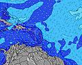 |  |  |  |  |  |  |  | |||||||||||||||
Onda Altezza (m) Direzione Periodo (s) | ESE 6 | ESE 7 | ESE 7 | ESE 7 | ESE 7 | ESE 8 | ESE 7 | ESE 7 | ESE 7 | ESE 8 | ESE 8 | ESE 7 | ESE 8 | ESE 8 | ESE 7 | ESE 7 | ESE 8 | ESE 7 | ESE 7 | ESE 7 | ESE 7 | ESE 7 | ESE 7 | ESE 7 |
Grafico delle onde | ||||||||||||||||||||||||
200 | 220 | 227 | 281 | 294 | 302 | 280 | 345 | 302 | 256 | 276 | 314 | 336 | 345 | 349 | 328 | 250 | 237 | 231 | 212 | 192 | 214 | 218 | 206 | |
Vento (km/h) | ||||||||||||||||||||||||
Stato del vento onshore cross-onshore cross-shore cross-offshore offshore piatto | cross-on | cross-on | cross-on | on | on | cross-on | cross-on | cross-on | cross | cross | cross-on | on | on | cross-on | cross-on | cross-on | cross | cross | cross-on | on | on | on | cross-on | cross-on |
Alta Marea | 9:49PM0.21m | 9:34PM0.22m | 10:56AM0.13m | 9:02PM0.23m | ||||||||||||||||||||
Basso Marea | 1:08PM0.07m | 1:28PM0.10m | 4:05AM0.11m | 1:43PM0.12m | ||||||||||||||||||||
— | 6:01 | — | — | — | — | — | — | — | 6:01 | — | — | — | — | — | — | — | 6:01 | — | — | — | — | — | — | |
— | — | — | — | — | 7:06 | — | — | — | — | — | — | — | 7:06 | — | — | — | — | — | — | — | 7:05 | — | — | |
mm | — | — | — | — | — | — | — | — | — | — | — | — | — | 2 | 1 | — | — | — | — | — | — | 2 | 2 | — |
Temp. °C | 25 | 25 | 27 | 29 | 29 | 29 | 28 | 27 | 26 | 25 | 27 | 29 | 29 | 28 | 27 | 26 | 25 | 25 | 27 | 30 | 29 | 28 | 27 | 26 |
Gelo °C | 26 | 26 | 28 | 28 | 28 | 30 | 29 | 28 | 27 | 26 | 28 | 28 | 28 | 29 | 28 | 28 | 27 | 27 | 29 | 30 | 29 | 29 | 29 | 28 |
Onda 1 Altezza (m) Direzione Periodo (s) | — | — | — | — | — | ESE 8 | — | — | — | ESE 8 | — | — | — | — | — | — | — | — | — | — | — | — | — | — |
— | — | — | — | — | 302 | — | — | — | 256 | — | — | — | — | — | — | — | — | — | — | — | — | — | — | |
Onda 2 Altezza (m) Direzione Periodo (s) | — | — | — | — | — | — | — | — | — | — | — | — | — | — | — | — | — | — | — | — | — | — | — | — |
— | — | — | — | — | — | — | — | — | — | — | — | — | — | — | — | — | — | — | — | — | — | — | — | |
Onda 3 Altezza (m) Direzione Periodo (s) | — | — | — | — | — | — | — | — | — | — | — | — | — | — | — | — | — | — | — | — | — | — | — | — |
— | — | — | — | — | — | — | — | — | — | — | — | — | — | — | — | — | — | — | — | — | — | — | — | |
onde vento Altezza (m) Direzione Periodo (s) | ESE 6 | ESE 7 | ESE 7 | ESE 7 | ESE 7 | — | ESE 7 | ESE 7 | ESE 7 | — | ESE 8 | ESE 7 | ESE 8 | ESE 8 | ESE 7 | ESE 7 | ESE 8 | ESE 7 | ESE 7 | ESE 7 | ESE 7 | ESE 7 | ESE 7 | ESE 7 |
200 | 220 | 227 | 281 | 294 | — | 280 | 345 | 302 | — | 276 | 314 | 336 | 345 | 349 | 328 | 250 | 237 | 231 | 212 | 192 | 214 | 218 | 206 | |
Il più vicino Offshore or Glassy | ||||||||||||||||||||||||
Distanza (km) | 323 | 323 | 323 | 814 | 436 | 595 | 595 | 94 | 63 | 64 | 93 | 812 | 279 | 814 | 595 | 323 | 63 | 64 | 69 | 814 | 436 | 595 | 595 | 94 |
Migliori previsioni per le condizioni d'onda in Puerto Rico | ||||||||||||||||||||||||
Migliori previsioni per le condizioni d'onda in Puerto Rico | ||||||||||||||||||||||||
Trova Onde Globale | ||||||||||||||||||||||||
- Map Icons:
 Break
Break Live Wave Height (m)
 Live Wind Speed (km/h)
 Surf Rating (10 Max)
 Ocean Swells (m)
- Wind Speed (km/h)
Widget Free Surf-Forecast.com per il tuo sito
La relazione di surf / widget meteo è disponibile qui sotto per incorporare su siti esterni a titolo gratuito e fornisce una sintesi delle nostre Punta de Brea previsione surf. Basta prendere il frammento di codice html da noi fornito e copiarlo nel proprio sito. È possibile scegliere la lingua preferita e unità metriche / imperiali per il feed delle previsioni surf per soddisfare le esigenze degli utenti del vostro sito .... Clicca qui per ottenere il codice.
 Nearest