
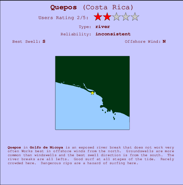
Quepos Surf Guide
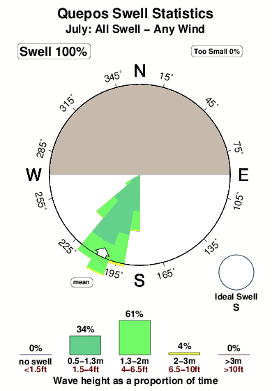
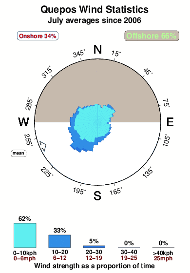
Quepos in Golfo de Nicoya is an exposed beach break that has unreliable waves Offshore winds blow from the north. Most of the surf here comes from groundswells and the best swell direction is from the south. Waves at the beach break both left and right. Good surf at all stages of the tide. Unlikely to be too crowded, even when the surf is up. Surfing here means negotiating dangerous rips.
Quepos Spot Info
| Type: | Rating: | Reliability: | Todays Sea Temp*: |
|---|---|---|---|
| inconsistent | 30.3°C*ocean temperature recorded from satellite |
Surfing Quepos:
The best conditions reported for surf at Quepos occur when a South swell combines with an offshore wind direction from the North.

Previsioni Energia d'onda (Potenza): 12hrs


Quepos Surf:
Saturday, 18 July 2026, 16:38 Local time| Sabato 18 | Dom | |||
| 3PM | 6PM | 9PM | 0AM | |
| Wave (m) | ||||
| Periodo (s) | 12 | 12 | 13 | 13 |
| Vento (km/h) | ||||
| Stato del vento | on | glass | glass | glass |
- /breaks/Quepos/forecasts/latest
Quepos Surf Guide
Quepos in Golfo de Nicoya is an exposed beach break that has unreliable waves Offshore winds blow from the north. Most of the surf here comes from groundswells and the best swell direction is from the south. Waves at the beach break both left and right. Good surf at all stages of the tide. Unlikely to be too crowded, even when the surf is up. Surfing here means negotiating dangerous rips.
Quepos Spot Info
Type: Rating: Reliability: Todays Sea Temp*:  River
River 2
2inconsistent 30.3°C*ocean temperature recorded from satelliteSurfing Quepos:
The best conditions reported for surf at Quepos occur when a South swell combines with an offshore wind direction from the North.
Previsioni Energia d'onda (Potenza): 12hrs
Utilizzare la scheda di navigazione in alto per visualizzare Quepos temperatura del mare, Quepos fotografie, Quepos dettagliate previsioni onde, il vento e le previsioni meteo, Quepos webcam, vento corrente da Golfo de Nicoya stazioni meteo e Quepos previsioni marea. Il link Costa Rica mappe maree apre l'immagine grande, che mostra Costa Rica e dei mari circostanti. Queste mappe possono essere animate per mostrare le diverse componenti del moto ondoso, energia delle onde, periodo d'onda, altezza delle onde, insieme con le previsioni del vento e meteo, meteo corrente e osservazioni sullo stato del mare dal Costa Rica onda-boe, le navi passanti e stazioni meteo costiere. Ciascuna delle pagine di previsioni per questo surf break rappresenta uno strumento di wavefinder globale e regionale per individuare le migliori condizioni di surf nella zona intorno Quepos.
Quepos Surf:
Saturday, 18 July 2026, 16:38 Local timeSabato 18 Dom 3PM 6PM 9PM 0AM Wave (m) Periodo (s) 12 12 13 13 Vento (km/h) Stato del vento on glass glass glass - /breaks/Quepos/forecasts/latest
- /breaks/Quepos/forecasts/latest/six_day
Quepos Surf Guide
Quepos in Golfo de Nicoya is an exposed beach break that has unreliable waves Offshore winds blow from the north. Most of the surf here comes from groundswells and the best swell direction is from the south. Waves at the beach break both left and right. Good surf at all stages of the tide. Unlikely to be too crowded, even when the surf is up. Surfing here means negotiating dangerous rips.
Quepos Spot Info
Type: Rating: Reliability: Todays Sea Temp*: River2inconsistent 30.3°C*ocean temperature recorded from satelliteSurfing Quepos:
The best conditions reported for surf at Quepos occur when a South swell combines with an offshore wind direction from the North.
Previsioni Energia d'onda (Potenza): 12hrs
Utilizzare la scheda di navigazione in alto per visualizzare Quepos temperatura del mare, Quepos fotografie, Quepos dettagliate previsioni onde, il vento e le previsioni meteo, Quepos webcam, vento corrente da Golfo de Nicoya stazioni meteo e Quepos previsioni marea. Il link Costa Rica mappe maree apre l'immagine grande, che mostra Costa Rica e dei mari circostanti. Queste mappe possono essere animate per mostrare le diverse componenti del moto ondoso, energia delle onde, periodo d'onda, altezza delle onde, insieme con le previsioni del vento e meteo, meteo corrente e osservazioni sullo stato del mare dal Costa Rica onda-boe, le navi passanti e stazioni meteo costiere. Ciascuna delle pagine di previsioni per questo surf break rappresenta uno strumento di wavefinder globale e regionale per individuare le migliori condizioni di surf nella zona intorno Quepos.
Quepos Surf:
Saturday, 18 July 2026, 16:38 Local timeSabato 18 Dom 3PM 6PM 9PM 0AM Wave (m) Periodo (s) 12 12 13 13 Vento (km/h) Stato del vento on glass glass glass - /breaks/Quepos/forecasts/latest
Quepos Surf Guide
Quepos in Golfo de Nicoya is an exposed beach break that has unreliable waves Offshore winds blow from the north. Most of the surf here comes from groundswells and the best swell direction is from the south. Waves at the beach break both left and right. Good surf at all stages of the tide. Unlikely to be too crowded, even when the surf is up. Surfing here means negotiating dangerous rips.
Quepos Spot Info
Type: Rating: Reliability: Todays Sea Temp*: River2inconsistent 30.3°C*ocean temperature recorded from satelliteSurfing Quepos:
The best conditions reported for surf at Quepos occur when a South swell combines with an offshore wind direction from the North.
Previsioni Energia d'onda (Potenza): 12hrs
Utilizzare la scheda di navigazione in alto per visualizzare Quepos temperatura del mare, Quepos fotografie, Quepos dettagliate previsioni onde, il vento e le previsioni meteo, Quepos webcam, vento corrente da Golfo de Nicoya stazioni meteo e Quepos previsioni marea. Il link Costa Rica mappe maree apre l'immagine grande, che mostra Costa Rica e dei mari circostanti. Queste mappe possono essere animate per mostrare le diverse componenti del moto ondoso, energia delle onde, periodo d'onda, altezza delle onde, insieme con le previsioni del vento e meteo, meteo corrente e osservazioni sullo stato del mare dal Costa Rica onda-boe, le navi passanti e stazioni meteo costiere. Ciascuna delle pagine di previsioni per questo surf break rappresenta uno strumento di wavefinder globale e regionale per individuare le migliori condizioni di surf nella zona intorno Quepos.
Quepos Surf:
Saturday, 18 July 2026, 16:38 Local timeSabato 18 Dom 3PM 6PM 9PM 0AM Wave (m) Periodo (s) 12 12 13 13 Vento (km/h) Stato del vento on glass glass glass Tide Times:
A Quepos (0 km).
PROSSIMA È ALLE (ora locale) rimanente alta marea bassa marea Quepos Tide Times and Tide Chart
Live Weather:
At Tobias Bolano Airport, 55 km from Quepos.
fresh winds from the ENE
(km/h)
Dry and partly cloudyAir temperature
25°COverall Quepos Surf Consistency and Wind Distribution in Luglio
foto dall' album
Contorni: Strade e fiumi: seleziona un surf break dal menu 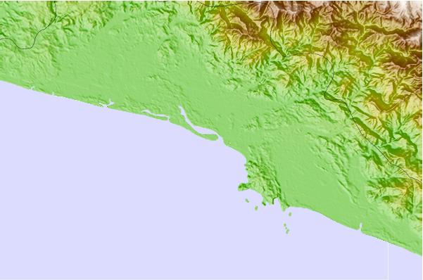
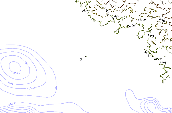
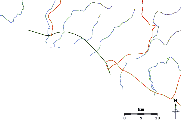
Utilizzare questa mappa sollievo per navigare Golfo de Nicoya surf breaks e stazioni di marea che si trovano nella zona diQuepos
Altri surf breaks più vicini al Quepos:
(clicca sul nome del luogo per maggiori informazioni)- Closest località surf5 mi
- Second closest località surf5 mi
- Third closest località surf7 mi
- Fourth closest località surf9 mi
- Fifth closest località surf16 mi
Onda boe più vicina a Quepos:
- Closest Onda boa541 mi
- Second closest Onda boa722 mi
- Third closest Onda boa1087 mi
- Fourth closest Onda boa1124 mi
- Fifth closest Onda boa1145 mi
Stazioni di marea più vicina alla Quepos:
- Closest marea stazioneChacarita53 mi
- Second closest marea stazionePunta Arenas55 mi
- Third closest marea stazioneLimon89 mi
- Fourth closest marea stazioneGolfito91 mi
- Fifth closest marea stazioneSan Juan del Norte (Greytown)107 mi
Airports
- The closest passenger airport to Quepos is Quepos Managua Airport (XQP) in Costa Rica, 9 km (6 miles) away (directly).
- The second nearest airport to Quepos is Juan Santamaria International Airport (SJO), also in Costa Rica, 60 km (37 miles) away.
- Third is Palmar Sur Airport (PMZ) in Costa Rica, 99 km (61 miles) away.
- Limon International Airport (LIO) in Costa Rica is 142 km (88 miles) away.
- Golfito Airport (GLF), also in Costa Rica is the fifth nearest airport to Quepos and is 144 km (89 miles) away.
- /breaks/Quepos/forecasts/latest


 Nearest