
Previsioni:

Previsione a breve terminePioggia abbondante (Totale 24mm), più pesante durante venerdì notte. Warm (Max 31°C mercoledì mattina, Min 25°C Venerdì notte). Vento sarà generalmente leggero. | ||||||||||||||||||||||||
Mercoledì 15 | Giovedì 16 | Venerdì 17 | 18 | |||||||||||||||||||||
8 AM | 11 AM | 2 PM | 5 PM | 8 PM | 11 PM | 2 AM | 5 AM | 8 AM | 11 AM | 2 PM | 5 PM | 8 PM | 11 PM | 2 AM | 5 AM | 8 AM | 11 AM | 2 PM | 5 PM | 8 PM | 11 PM | 2 AM | 5 AM | |
Mappa dell'altezza del moto ondoso |  |  |  |  |  |  |  |  | 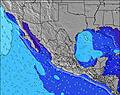 | |||||||||||||||
Onda Altezza (m) Direzione Periodo (s) | SSW 12 | SSW 12 | SW 16 | SW 16 | SW 16 | SW 16 | SW 16 | SW 16 | SW 16 | SW 16 | SSW 13 | SW 15 | SW 15 | SW 15 | SW 15 | SW 15 | SW 15 | SSW 12 | SSW 11 | SSW 10 | SSW 10 | SW 17 | SW 17 | SW 17 |
Grafico delle onde | ||||||||||||||||||||||||
129 | 106 | 167 | 208 | 208 | 163 | 163 | 163 | 163 | 125 | 101 | 181 | 107 | 137 | 136 | 136 | 136 | 153 | 186 | 173 | 163 | 293 | 297 | 427 | |
Vento (km/h) | ||||||||||||||||||||||||
Stato del vento onshore cross-onshore cross-shore cross-offshore offshore piatto | off | cross-on | on | cross-on | cross | cross-off | glassy | off | cross-off | cross-on | on | cross-on | cross | glassy | cross-off | off | glassy | on | on | cross-on | cross | off | off | cross-off |
Alta Marea | 10:14AM1.42m | 9:04PM1.78m | 10:47AM1.42m | 9:47PM1.66m | 11:18AM1.41m | 10:28PM1.49m | ||||||||||||||||||
Basso Marea | 3:10PM0.82m | 4:07AM0.06m | 3:54PM0.80m | 4:40AM0.22m | 4:40PM0.80m | |||||||||||||||||||
5:28 | — | — | — | — | — | — | 5:28 | — | — | — | — | — | — | — | 5:28 | — | — | — | — | — | — | — | 5:30 | |
— | — | — | 6:54 | — | — | — | — | — | — | — | 6:54 | — | — | — | — | — | — | — | 6:53 | — | — | — | 6:53 | |
mm | — | — | — | — | — | 1 | — | 1 | 1 | — | — | — | — | — | 1 | — | — | — | — | — | 1 | 4 | 11 | 4 |
Temp. °C | 28 | 31 | 31 | 30 | 29 | 27 | 27 | 26 | 28 | 30 | 30 | 30 | 29 | 28 | 27 | 27 | 28 | 30 | 30 | 30 | 28 | 26 | 25 | 25 |
Gelo °C | 32 | 34 | 33 | 32 | 33 | 31 | 32 | 30 | 32 | 33 | 32 | 32 | 33 | 33 | 31 | 31 | 33 | 33 | 32 | 31 | 31 | 30 | 28 | 28 |
Onda 1 Altezza (m) Direzione Periodo (s) | SSW 12 | SSW 12 | SSW 12 | SW 16 | SW 16 | SW 16 | SW 16 | SW 16 | SSW 13 | SSW 13 | SSW 13 | SW 15 | SW 15 | SW 15 | SW 15 | SW 15 | SSW 9 | SSW 12 | SSW 11 | SSW 10 | SSW 10 | SSW 10 | SSW 10 | SSW 10 |
129 | 98 | 98 | 208 | 208 | 163 | 163 | 163 | 114 | 116 | 101 | 181 | 107 | 137 | 136 | 136 | 78 | 153 | 186 | 173 | 163 | 173 | 166 | 160 | |
Onda 2 Altezza (m) Direzione Periodo (s) | SW 18 | SW 17 | SW 16 | SSW 12 | SSW 12 | SSW 12 | SW 12 | SSW 13 | SW 16 | SW 16 | SSW 7 | SSW 7 | SSW 12 | SW 19 | SSW 12 | SW 19 | SW 15 | SW 15 | SW 15 | SW 15 | SW 15 | SW 17 | SW 17 | SW 17 |
79 | 106 | 167 | 98 | 98 | 101 | 72 | 114 | 163 | 125 | 26 | 15 | 61 | 130 | 82 | 130 | 136 | 104 | 104 | 104 | 134 | 293 | 297 | 427 | |
Onda 3 Altezza (m) Direzione Periodo (s) | S 8 | S 8 | SSW 8 | SSW 8 | SSW 8 | S 8 | S 7 | S 7 | S 7 | SSW 7 | SW 16 | SSW 9 | SSW 7 | SSW 7 | SW 19 | SSW 12 | SW 19 | SW 19 | SW 18 | SW 18 | SW 18 | WNW 4 | WNW 4 | WNW 5 |
12 | 12 | 22 | 24 | 19 | 29 | 28 | 27 | 25 | 16 | 90 | 17 | 15 | 15 | 130 | 57 | 130 | 123 | 51 | 50 | 49 | 3 | 6 | 8 | |
onde vento Altezza (m) Direzione Periodo (s) | — | — | — | W 2 | — | — | — | — | — | — | — | WSW 2 | W 3 | — | — | — | — | — | WNW 4 | W 4 | WNW 2 | — | — | — |
— | — | — | 1 | — | — | — | — | — | — | — | 1 | 3 | — | — | — | — | — | 2 | 3 | 1 | — | — | — | |
Il più vicino Offshore or Glassy | ||||||||||||||||||||||||
Distanza (km) | 0 | 300 | 310 | 294 | 64 | 0 | 0 | 0 | 0 | 311 | 310 | 310 | 17 | 0 | 0 | 0 | 0 | 310 | 310 | 294 | 17 | 0 | 0 | 0 |
Migliori previsioni per le condizioni d'onda in Sinaloa | ||||||||||||||||||||||||
Migliori previsioni per le condizioni d'onda in Mexico | ||||||||||||||||||||||||
Trova Onde Globale | ||||||||||||||||||||||||
- Map Icons:
 Break
Break Live Wave Height (m)
 Live Wind Speed (km/h)
 Surf Rating (10 Max)
 Ocean Swells (m)
- Wind Speed (km/h)
Widget Free Surf-Forecast.com per il tuo sito
La relazione di surf / widget meteo è disponibile qui sotto per incorporare su siti esterni a titolo gratuito e fornisce una sintesi delle nostre Quijote Inn Peak previsione surf. Basta prendere il frammento di codice html da noi fornito e copiarlo nel proprio sito. È possibile scegliere la lingua preferita e unità metriche / imperiali per il feed delle previsioni surf per soddisfare le esigenze degli utenti del vostro sito .... Clicca qui per ottenere il codice.
 Nearest