
Previsioni:

Previsione a breve termineper lo più asciutto. Warm (Max 23°C martedì pomeriggio, Min 19°C Sabato notte). Vento sarà generalmente leggero. | |||||||||||||||||||
1 | Domenica 2 | Lunedì 3 | |||||||||||||||||
5 PM | 8 PM | 11 PM | 2 AM | 5 AM | 8 AM | 11 AM | 2 PM | 5 PM | 8 PM | 11 PM | 2 AM | 5 AM | 8 AM | 11 AM | 2 PM | 5 PM | 8 PM | 11 PM | |
Mappa dell'altezza del moto ondoso | 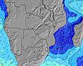 | 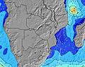 | 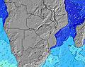 | 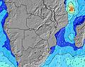 | 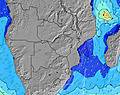 | 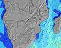 | 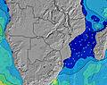 | ||||||||||||
Onda Altezza (m) Direzione Periodo (s) | S 10 | S 10 | S 10 | S 10 | S 10 | S 11 | S 11 | S 11 | S 10 | S 10 | S 12 | S 12 | S 11 | S 11 | S 11 | SSE 11 | SSE 10 | SSE 10 | SSE 10 |
Grafico delle onde | |||||||||||||||||||
1849 | 1695 | 1618 | 1618 | 1960 | 2918 | 2945 | 2401 | 1836 | 1570 | 2202 | 2000 | 1655 | 1504 | 1354 | 1027 | 787 | 706 | 625 | |
Vento (km/h) | |||||||||||||||||||
Stato del vento onshore cross-onshore cross-shore cross-offshore offshore piatto | cross | cross | cross | cross | cross | cross-off | cross | cross | cross | cross | cross-off | cross-off | cross-off | cross-off | cross | cross | cross-on | cross-on | on |
Alta Marea | 5:33PM2.40m | 5:43AM2.33m | 6:02PM2.38m | 6:12AM2.27m | 6:33PM2.31m | ||||||||||||||
Basso Marea | 11:40PM0.19m | 11:51AM0.11m | 00:10AM0.24m | 12:21PM0.17m | |||||||||||||||
— | — | — | — | 6:18 | — | — | — | — | — | — | — | 6:16 | — | — | — | — | — | — | |
5:15 | — | — | — | — | — | — | — | 5:16 | — | — | — | — | — | — | — | 5:16 | — | — | |
mm | — | — | — | — | — | — | — | — | — | — | — | — | — | — | — | — | — | — | — |
Temp. °C | 20 | 20 | 20 | 20 | 19 | 19 | 20 | 19 | 19 | 20 | 20 | 20 | 19 | 19 | 22 | 22 | 21 | 21 | 21 |
Gelo °C | 15 | 15 | 15 | 15 | 15 | 16 | 16 | 14 | 16 | 19 | 20 | 19 | 19 | 18 | 20 | 20 | 21 | 22 | 22 |
Onda 1 Altezza (m) Direzione Periodo (s) | ESE 10 | SE 11 | ESE 10 | SE 11 | ESE 11 | S 11 | S 11 | S 11 | S 10 | S 10 | S 12 | S 12 | S 11 | S 11 | S 11 | SSE 11 | SSE 10 | SSE 10 | SSE 10 |
20 | 29 | 20 | 30 | 23 | 2301 | 2445 | 2401 | 1836 | 1570 | 2202 | 2000 | 1655 | 1504 | 1354 | 1027 | 787 | 706 | 625 | |
Onda 2 Altezza (m) Direzione Periodo (s) | S 16 | S 16 | — | S 15 | SW 15 | ESE 11 | ESE 11 | ESE 10 | ESE 10 | ESE 10 | ESE 10 | ESE 10 | S 18 | S 18 | SW 17 | S 17 | S 17 | SW 15 | SSW 17 |
21 | 21 | — | 17 | 9 | 22 | 11 | 10 | 10 | 10 | 10 | 10 | 6 | 6 | 11 | 6 | 6 | 9 | 29 | |
Onda 3 Altezza (m) Direzione Periodo (s) | SSW 16 | — | — | — | — | — | — | — | ESE 10 | — | — | S 18 | — | — | — | — | — | S 18 | S 15 |
51 | — | — | — | — | — | — | — | 10 | — | — | 6 | — | — | — | — | — | 6 | 4 | |
onde vento Altezza (m) Direzione Periodo (s) | S 10 | S 10 | S 10 | S 10 | S 10 | S 11 | S 11 | — | SW 9 | SW 8 | SW 9 | SW 8 | SW 8 | SW 7 | — | — | — | — | — |
1849 | 1695 | 1618 | 1618 | 1960 | 2918 | 2945 | — | 840 | 297 | 349 | 235 | 221 | 240 | — | — | — | — | — | |
Il più vicino Offshore or Glassy | |||||||||||||||||||
Distanza (km) | 1237 | 139 | 139 | 118 | 63 | 63 | 139 | 138 | 138 | 138 | 63 | 0 | 0 | 63 | 118 | 668 | 999 | 138 | 118 |
Migliori previsioni per le condizioni d'onda in Inhambane | |||||||||||||||||||
Migliori previsioni per le condizioni d'onda in Mozambique | |||||||||||||||||||
Trova Onde Globale | |||||||||||||||||||
- Map Icons:
 Break
Break Live Wave Height (m)
 Live Wind Speed (km/h)
 Surf Rating (10 Max)
 Ocean Swells (m)
- Wind Speed (km/h)
Widget Free Surf-Forecast.com per il tuo sito
La relazione di surf / widget meteo è disponibile qui sotto per incorporare su siti esterni a titolo gratuito e fornisce una sintesi delle nostre Quissico previsione surf. Basta prendere il frammento di codice html da noi fornito e copiarlo nel proprio sito. È possibile scegliere la lingua preferita e unità metriche / imperiali per il feed delle previsioni surf per soddisfare le esigenze degli utenti del vostro sito .... Clicca qui per ottenere il codice.
 Nearest