
Previsioni:

Previsione a breve termineper lo più asciutto. Very mild (Max 17°C giovedì pomeriggio, Min 12°C mercoledì notte). Vento sarà generalmente leggero. | ||||||||||||||||||
Mer 15 | Giovedì 16 | Venerdì 17 | ||||||||||||||||
8 PM | 11 PM | 2 AM | 5 AM | 8 AM | 11 AM | 2 PM | 5 PM | 8 PM | 11 PM | 2 AM | 5 AM | 8 AM | 11 AM | 2 PM | 5 PM | 8 PM | 11 PM | |
Mappa dell'altezza del moto ondoso |  |  | 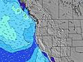 |  |  | 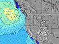 |  | |||||||||||
Onda Altezza (m) Direzione Periodo (s) | WNW 9 | WNW 20 | SW 16 | WNW 19 | WNW 19 | WNW 19 | WNW 19 | WNW 18 | WNW 18 | WNW 18 | WNW 17 | WNW 17 | WNW 17 | WNW 17 | WNW 17 | NW 7 | NW 7 | WNW 16 |
Grafico delle onde | ||||||||||||||||||
133 | 216 | 214 | 286 | 283 | 283 | 280 | 352 | 333 | 413 | 428 | 423 | 428 | 522 | 492 | 567 | 457 | 457 | |
Vento (km/h) | ||||||||||||||||||
Stato del vento onshore cross-onshore cross-shore cross-offshore offshore piatto | cross-off | cross-off | off | off | glassy | cross | cross | cross | cross-off | cross-off | cross-off | cross-off | glassy | cross | cross | cross | cross-off | glassy |
Alta Marea | 00:56AM2.41m | 2:33PM1.93m | 1:48AM2.25m | 3:14PM1.98m | ||||||||||||||
Basso Marea | 7:04PM0.72m | 7:58AM-0.54m | 8:00PM0.64m | 8:40AM-0.37m | 8:57PM0.57m | |||||||||||||
— | — | — | 5:54 | — | — | — | — | — | — | — | 5:56 | — | — | — | — | — | — | |
8:51 | — | — | — | — | — | — | — | 8:50 | — | — | — | — | — | — | — | 8:50 | — | |
mm | — | — | — | — | — | — | — | — | — | — | — | — | — | — | — | — | — | — |
Temp. °C | 15 | 13 | 12 | 12 | 13 | 16 | 17 | 16 | 15 | 13 | 12 | 12 | 13 | 14 | 17 | 17 | 16 | 13 |
Gelo °C | 13 | 12 | 11 | 11 | 12 | 13 | 13 | 11 | 11 | 11 | 10 | 11 | 12 | 11 | 14 | 13 | 14 | 13 |
Onda 1 Altezza (m) Direzione Periodo (s) | WNW 9 | WNW 9 | WNW 9 | WNW 9 | WNW 9 | WNW 19 | WNW 19 | WNW 18 | WNW 18 | WNW 18 | WNW 17 | WNW 17 | NW 6 | WNW 17 | WNW 17 | WNW 16 | WNW 16 | WNW 16 |
121 | 119 | 94 | 92 | 70 | 283 | 280 | 352 | 333 | 413 | 428 | 423 | 60 | 522 | 492 | 469 | 457 | 457 | |
Onda 2 Altezza (m) Direzione Periodo (s) | SW 17 | WNW 20 | WNW 19 | WNW 19 | WNW 19 | SW 16 | SW 16 | SW 16 | SW 16 | SW 16 | SW 16 | SW 15 | WNW 17 | SW 19 | SW 19 | SW 19 | SW 14 | WNW 12 |
103 | 216 | 214 | 286 | 283 | 161 | 159 | 159 | 159 | 157 | 155 | 186 | 428 | 231 | 231 | 181 | 74 | 93 | |
Onda 3 Altezza (m) Direzione Periodo (s) | WNW 20 | SW 16 | SW 16 | SW 16 | SW 16 | WNW 12 | SSW 12 | WNW 12 | WNW 12 | SSW 12 | WNW 8 | WNW 8 | SW 15 | SW 15 | SW 14 | SW 14 | SW 19 | SW 14 |
133 | 130 | 163 | 161 | 161 | 30 | 26 | 29 | 29 | 13 | 26 | 26 | 106 | 104 | 103 | 74 | 177 | 103 | |
onde vento Altezza (m) Direzione Periodo (s) | NW 5 | NW 5 | NW 5 | — | — | NW 9 | NW 5 | NW 6 | NW 6 | NW 6 | NW 6 | NW 7 | NW 6 | NW 6 | NW 6 | NW 7 | NW 7 | NW 7 |
69 | 32 | 23 | — | — | 112 | 90 | 157 | 185 | 146 | 136 | 111 | 136 | 122 | 297 | 567 | 434 | 305 | |
Il più vicino Offshore or Glassy | ||||||||||||||||||
Distanza (km) | 39 | 20 | 20 | 20 | 20 | 538 | 538 | 538 | 538 | 20 | 20 | 20 | 20 | 34 | 602 | 602 | 34 | 20 |
Migliori previsioni per le condizioni d'onda in South Oregon | ||||||||||||||||||
Migliori previsioni per le condizioni d'onda in United States | ||||||||||||||||||
Trova Onde Globale | ||||||||||||||||||
- Map Icons:
 Break
Break Live Wave Height (m)
 Live Wind Speed (km/h)
 Surf Rating (10 Max)
 Ocean Swells (m)
- Wind Speed (km/h)
Widget Free Surf-Forecast.com per il tuo sito
La relazione di surf / widget meteo è disponibile qui sotto per incorporare su siti esterni a titolo gratuito e fornisce una sintesi delle nostre Rainbow Rocks previsione surf. Basta prendere il frammento di codice html da noi fornito e copiarlo nel proprio sito. È possibile scegliere la lingua preferita e unità metriche / imperiali per il feed delle previsioni surf per soddisfare le esigenze degli utenti del vostro sito .... Clicca qui per ottenere il codice.
 Nearest