
Previsioni:

Previsione a breve termineper lo più asciutto. Warm (Max 26°C mercoledì pomeriggio, Min 24°C giovedì notte). Principalmente raffiche di vento. | ||||||||||||||||||||||||
Mer 15 | Giovedì 16 | Venerdì 17 | 18 | |||||||||||||||||||||
1 PM | 4 PM | 7 PM | 10 PM | 1 AM | 4 AM | 7 AM | 10 AM | 1 PM | 4 PM | 7 PM | 10 PM | 1 AM | 4 AM | 7 AM | 10 AM | 1 PM | 4 PM | 7 PM | 10 PM | 1 AM | 4 AM | 7 AM | 10 AM | |
Mappa dell'altezza del moto ondoso | 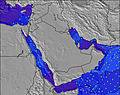 | 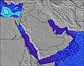 | 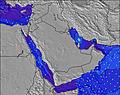 |  | 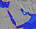 | 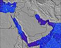 | 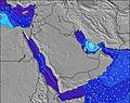 | 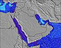 | 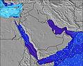 | 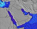 | ||||||||||||||
Onda Altezza (m) Direzione Periodo (s) | S 10 | S 10 | S 10 | S 10 | S 10 | S 10 | S 10 | S 10 | S 10 | S 10 | S 10 | S 10 | S 10 | S 10 | S 10 | S 10 | S 10 | S 10 | S 10 | S 10 | S 10 | S 10 | S 11 | S 11 |
Grafico delle onde | ||||||||||||||||||||||||
1545 | 1576 | 1466 | 1466 | 1466 | 1466 | 1466 | 1476 | 1586 | 1700 | 1700 | 1576 | 1466 | 1360 | 1360 | 1495 | 1608 | 1768 | 1905 | 1768 | 1803 | 1837 | 1924 | 1981 | |
Vento (km/h) | ||||||||||||||||||||||||
Stato del vento onshore cross-onshore cross-shore cross-offshore offshore piatto | cross | cross | cross | cross-on | cross | cross | cross | cross | cross | cross | cross | cross | cross | cross | cross | cross | cross | cross | cross | cross | cross | cross | cross | cross |
Alta Marea | 10:50AM2.40m | 9:42PM2.07m | 11:27AM2.42m | 10:40PM2.00m | 12:01PM2.40m | 11:38PM1.90m | ||||||||||||||||||
Basso Marea | 4:34PM1.20m | 4:27AM0.05m | 5:23PM1.05m | 5:10AM0.23m | 6:12PM0.91m | 5:50AM0.46m | ||||||||||||||||||
— | — | — | — | — | 5:31 | — | — | — | — | — | — | — | 5:31 | — | — | — | — | — | — | — | 5:33 | — | — | |
— | 6:46 | — | — | — | — | — | — | — | 6:46 | — | — | — | — | — | — | — | 6:46 | — | — | — | — | — | 6:46 | |
mm | — | — | — | — | — | — | — | — | — | — | — | — | — | — | — | — | — | — | — | — | — | — | — | — |
Temp. °C | 26 | 26 | 25 | 25 | 25 | 25 | 25 | 25 | 26 | 25 | 25 | 24 | 25 | 25 | 25 | 25 | 26 | 26 | 25 | 25 | 24 | 24 | 24 | 25 |
Gelo °C | 24 | 25 | 24 | 26 | 24 | 24 | 24 | 24 | 24 | 23 | 23 | 23 | 24 | 23 | 22 | 23 | 24 | 23 | 21 | 23 | 22 | 22 | 21 | 23 |
Onda 1 Altezza (m) Direzione Periodo (s) | S 16 | S 17 | S 17 | S 17 | S 10 | SSW 16 | SSW 16 | S 16 | SSW 16 | SSW 16 | SSW 15 | SSW 15 | SSW 15 | SSW 15 | SSW 15 | SSW 15 | SSW 15 | — | — | — | — | — | — | — |
48 | 50 | 49 | 50 | 1466 | 50 | 50 | 21 | 25 | 24 | 23 | 21 | 21 | 21 | 21 | 21 | 43 | — | — | — | — | — | — | — | |
Onda 2 Altezza (m) Direzione Periodo (s) | SSW 16 | S 17 | S 18 | S 15 | SSW 16 | S 17 | S 16 | SSW 16 | S 16 | S 16 | — | — | — | — | — | — | — | — | — | — | — | — | — | — |
25 | 23 | 6 | 4 | 53 | 22 | 21 | 25 | 21 | 21 | — | — | — | — | — | — | — | — | — | — | — | — | — | — | |
Onda 3 Altezza (m) Direzione Periodo (s) | S 18 | S 18 | S 18 | S 18 | S 17 | S 16 | — | — | S 16 | S 16 | — | — | — | — | — | — | — | — | — | — | — | — | — | — |
6 | 6 | 6 | 6 | 22 | 21 | — | — | 5 | 5 | — | — | — | — | — | — | — | — | — | — | — | — | — | — | |
onde vento Altezza (m) Direzione Periodo (s) | S 10 | S 10 | S 10 | S 10 | — | S 10 | S 10 | S 10 | S 10 | S 10 | S 10 | S 10 | S 10 | S 10 | S 10 | S 10 | S 10 | S 10 | S 10 | S 10 | S 10 | S 10 | S 11 | S 11 |
1545 | 1576 | 1466 | 1466 | — | 1466 | 1466 | 1476 | 1586 | 1700 | 1700 | 1576 | 1466 | 1360 | 1360 | 1495 | 1608 | 1768 | 1905 | 1768 | 1803 | 1837 | 1924 | 1981 | |
Il più vicino Offshore or Glassy | ||||||||||||||||||||||||
Distanza (km) | 2421 | 2584 | 2404 | 1702 | 1795 | 1759 | 621 | 2395 | 2395 | 2375 | 2395 | 1795 | 614 | 614 | 614 | 614 | 614 | 2455 | 614 | 614 | 614 | 674 | 614 | 614 |
Migliori previsioni per le condizioni d'onda in Masirah Island | ||||||||||||||||||||||||
Migliori previsioni per le condizioni d'onda in Oman | ||||||||||||||||||||||||
Trova Onde Globale | ||||||||||||||||||||||||
- Map Icons:
 Break
Break Live Wave Height (m)
 Live Wind Speed (km/h)
 Surf Rating (10 Max)
 Ocean Swells (m)
- Wind Speed (km/h)
Widget Free Surf-Forecast.com per il tuo sito
La relazione di surf / widget meteo è disponibile qui sotto per incorporare su siti esterni a titolo gratuito e fornisce una sintesi delle nostre Ras Al Ya previsione surf. Basta prendere il frammento di codice html da noi fornito e copiarlo nel proprio sito. È possibile scegliere la lingua preferita e unità metriche / imperiali per il feed delle previsioni surf per soddisfare le esigenze degli utenti del vostro sito .... Clicca qui per ottenere il codice.
 Nearest