

Road K Surf Guide
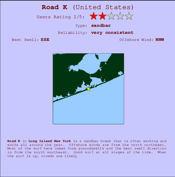
Road K in Long Island New York is an exposed sandbar break that has very consistent waves and works all around the year. The best wind direction is from the north northwest. Most of the surf here comes from groundswells and the ideal swell direction is from the south southeast. Good surf at all stages of the tide. A popular wave that can get growded.
Road K Spot Info
| Type: | Rating: | Reliability: | Todays Sea Temp*: |
|---|---|---|---|
| very consistent | 22.6°C*ocean temperature recorded from satellite |
Surfing Road K:
The best conditions reported for surf at Road K occur when a South-southeast swell combines with an offshore wind direction from the North-northwest.
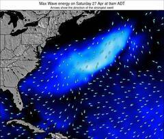
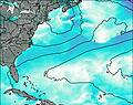
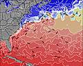
Previsioni Energia d'onda (Potenza): 12hrs

Road K Surf:
Saturday, 18 July 2026, 05:20 Local time| Sabato 18 | ||||
| 5AM | 8AM | 11AM | 2PM | |
| Wave (m) | ||||
| Periodo (s) | 14 | 4 | 4 | 4 |
| Vento (km/h) | ||||
| Stato del vento | cross- on |
cross- on |
cross- on |
cross |
- /breaks/Road-K/forecasts/latest
Road K Surf Guide
Road K in Long Island New York is an exposed sandbar break that has very consistent waves and works all around the year. The best wind direction is from the north northwest. Most of the surf here comes from groundswells and the ideal swell direction is from the south southeast. Good surf at all stages of the tide. A popular wave that can get growded.
Road K Spot Info
Type: Rating: Reliability: Todays Sea Temp*:  Sandbar
 2
2very consistent 22.6°C*ocean temperature recorded from satelliteSurfing Road K:
The best conditions reported for surf at Road K occur when a South-southeast swell combines with an offshore wind direction from the North-northwest.
Previsioni Energia d'onda (Potenza): 12hrs
Utilizzare la scheda di navigazione in alto per visualizzare Road K temperatura del mare, Road K fotografie, Road K dettagliate previsioni onde, il vento e le previsioni meteo, Road K webcam, vento corrente da Long Island NY stazioni meteo e Road K previsioni marea. Il link United States mappe maree apre l'immagine grande, che mostra United States e dei mari circostanti. Queste mappe possono essere animate per mostrare le diverse componenti del moto ondoso, energia delle onde, periodo d'onda, altezza delle onde, insieme con le previsioni del vento e meteo, meteo corrente e osservazioni sullo stato del mare dal United States onda-boe, le navi passanti e stazioni meteo costiere. Ciascuna delle pagine di previsioni per questo surf break rappresenta uno strumento di wavefinder globale e regionale per individuare le migliori condizioni di surf nella zona intorno Road K.
Road K Surf:
Saturday, 18 July 2026, 05:20 Local timeSabato 18 5AM 8AM 11AM 2PM Wave (m) Periodo (s) 14 4 4 4 Vento (km/h) Stato del vento cross-
oncross-
oncross-
oncross - /breaks/Road-K/forecasts/latest
- /breaks/Road-K/forecasts/latest/six_day
Road K Surf Guide
Road K in Long Island New York is an exposed sandbar break that has very consistent waves and works all around the year. The best wind direction is from the north northwest. Most of the surf here comes from groundswells and the ideal swell direction is from the south southeast. Good surf at all stages of the tide. A popular wave that can get growded.
Road K Spot Info
Type: Rating: Reliability: Todays Sea Temp*: Sandbar2very consistent 22.6°C*ocean temperature recorded from satelliteSurfing Road K:
The best conditions reported for surf at Road K occur when a South-southeast swell combines with an offshore wind direction from the North-northwest.
Previsioni Energia d'onda (Potenza): 12hrs
Utilizzare la scheda di navigazione in alto per visualizzare Road K temperatura del mare, Road K fotografie, Road K dettagliate previsioni onde, il vento e le previsioni meteo, Road K webcam, vento corrente da Long Island NY stazioni meteo e Road K previsioni marea. Il link United States mappe maree apre l'immagine grande, che mostra United States e dei mari circostanti. Queste mappe possono essere animate per mostrare le diverse componenti del moto ondoso, energia delle onde, periodo d'onda, altezza delle onde, insieme con le previsioni del vento e meteo, meteo corrente e osservazioni sullo stato del mare dal United States onda-boe, le navi passanti e stazioni meteo costiere. Ciascuna delle pagine di previsioni per questo surf break rappresenta uno strumento di wavefinder globale e regionale per individuare le migliori condizioni di surf nella zona intorno Road K.
Road K Surf:
Saturday, 18 July 2026, 05:20 Local timeSabato 18 5AM 8AM 11AM 2PM Wave (m) Periodo (s) 14 4 4 4 Vento (km/h) Stato del vento cross-
oncross-
oncross-
oncross - /breaks/Road-K/forecasts/latest
Road K Surf Guide
Road K in Long Island New York is an exposed sandbar break that has very consistent waves and works all around the year. The best wind direction is from the north northwest. Most of the surf here comes from groundswells and the ideal swell direction is from the south southeast. Good surf at all stages of the tide. A popular wave that can get growded.
Road K Spot Info
Type: Rating: Reliability: Todays Sea Temp*: Sandbar2very consistent 22.6°C*ocean temperature recorded from satelliteSurfing Road K:
The best conditions reported for surf at Road K occur when a South-southeast swell combines with an offshore wind direction from the North-northwest.
Previsioni Energia d'onda (Potenza): 12hrs
Utilizzare la scheda di navigazione in alto per visualizzare Road K temperatura del mare, Road K fotografie, Road K dettagliate previsioni onde, il vento e le previsioni meteo, Road K webcam, vento corrente da Long Island NY stazioni meteo e Road K previsioni marea. Il link United States mappe maree apre l'immagine grande, che mostra United States e dei mari circostanti. Queste mappe possono essere animate per mostrare le diverse componenti del moto ondoso, energia delle onde, periodo d'onda, altezza delle onde, insieme con le previsioni del vento e meteo, meteo corrente e osservazioni sullo stato del mare dal United States onda-boe, le navi passanti e stazioni meteo costiere. Ciascuna delle pagine di previsioni per questo surf break rappresenta uno strumento di wavefinder globale e regionale per individuare le migliori condizioni di surf nella zona intorno Road K.
Road K Surf:
Saturday, 18 July 2026, 05:20 Local timeSabato 18 5AM 8AM 11AM 2PM Wave (m) Periodo (s) 14 4 4 4 Vento (km/h) Stato del vento cross-
oncross-
oncross-
oncross Tide Times:
Per Shinnecock Inlet (ocean), Long Island, New York, %{dist} %{km} da %{location}.
PROSSIMA È ALLE (ora locale) rimanente alta marea bassa marea Road K Tide Times and Tide Chart
Live Weather:
At Westhampton Beach/Francis S. Gabreski Airport, 9 km from Road K.
calm
(km/h)
ClearAir temperature
15.0°COverall Road K Surf Consistency and Wind Distribution in Luglio
foto dall' album
Contorni: Strade e fiumi: seleziona un surf break dal menu 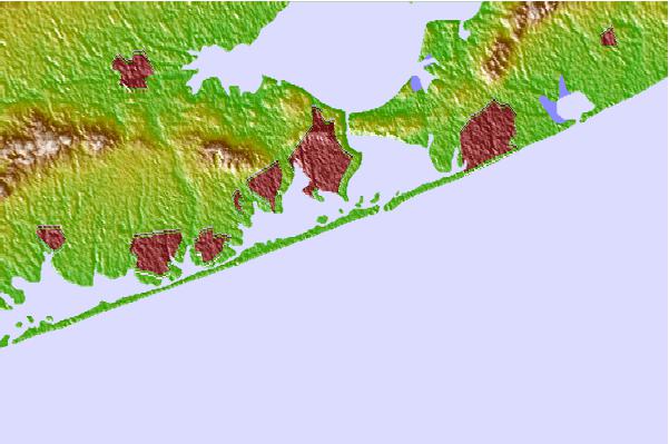
Utilizzare questa mappa sollievo per navigare Long Island NY surf breaks e stazioni di marea che si trovano nella zona diRoad K
Altri surf breaks più vicini al Road K:
(clicca sul nome del luogo per maggiori informazioni)- Closest località surf1 mi
- Second closest località surf2 mi
- Third closest località surf2 mi
- Fourth closest località surf9 mi
- Fifth closest località surf11 mi
Onda boe più vicina a Road K:
- Closest Onda boa22 mi
- Second closest Onda boa26 mi
- Third closest Onda boa53 mi
- Fourth closest Onda boa57 mi
- Fifth closest Onda boa70 mi
Stazioni di marea più vicina alla Road K:
- Closest marea stazionePonquogue Bridge1 mi
- Second closest marea stazionePonquoque Point, Shinnecock Bay1 mi
- Third closest marea stazioneShinnecock Inlet (ocean), Long Island2 mi
- Fourth closest marea stazioneShinnecock Yacht Club, Penniman Creek, Shinnecock Bay2 mi
- Fifth closest marea stazioneShinnecock Bay entrance, Shinnecock Bay3 mi
Airports
- The closest passenger airport to Road K is The Francis S Gabreski (West Hampton Beach) Airport (FOK) in USA, 10 km (6 miles) away (directly).
- The second nearest airport to Road K is Long Island Mac Arthur (Islip) Airport (ISP), also in USA, 50 km (31 miles) away.
- Third is Igor I Sikorsky Mem (Stratford) Airport (BDR) in USA, 63 km (39 miles) away.
- Hartford Brainard Airport (HFD) in USA is 101 km (63 miles) away.
- Westchester Co (White Plains) Airport (HPN), also in USA is the fifth nearest airport to Road K and is 104 km (65 miles) away.
- /breaks/Road-K/forecasts/latest


 Nearest