
Roads End Surf Guide
Roads End in Oregon_North is an exposed beach and reef break that has fairly consistent surf and can work at any time of the year. The best wind direction is from the east. Most of the surf here comes from groundswells and the optimum swell angle is from the west. Waves at the beach break both left and right together with both left and right hand reef breaks offshore.. When it's working here, it can get crowded. Take care of rips and sharks.
Roads End Spot Info
| Type: | Rating: | Reliability: | Todays Sea Temp*: |
|---|---|---|---|
| fairly consistent | 11.8°C*ocean temperature recorded from satellite |
Surfing Roads End:
The best conditions reported for surf at Roads End occur when a West swell combines with an offshore wind direction from the East.
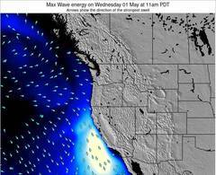
Previsioni Energia d'onda (Potenza): 12hrs

Roads End Surf:
Sunday, 19 July 2026, 08:01 Local time| Domenica 19 | ||||
| 8AM | 11AM | 2PM | 5PM | |
| Wave (m) | ||||
| Periodo (s) | 15 | 7 | 7 | 7 |
| Vento (km/h) | ||||
| Stato del vento | cross | cross | cross | cross |
- /breaks/Roads-End/forecasts/latest
Roads End Surf Guide
Roads End in Oregon_North is an exposed beach and reef break that has fairly consistent surf and can work at any time of the year. The best wind direction is from the east. Most of the surf here comes from groundswells and the optimum swell angle is from the west. Waves at the beach break both left and right together with both left and right hand reef breaks offshore.. When it's working here, it can get crowded. Take care of rips and sharks.
Roads End Spot Info
Type: Rating: Reliability: Todays Sea Temp*:  Beach and reef
 1
1fairly consistent 11.8°C*ocean temperature recorded from satelliteSurfing Roads End:
The best conditions reported for surf at Roads End occur when a West swell combines with an offshore wind direction from the East.
Previsioni Energia d'onda (Potenza): 12hrs
Utilizzare la scheda di navigazione in alto per visualizzare Roads End temperatura del mare, Roads End fotografie, Roads End dettagliate previsioni onde, il vento e le previsioni meteo, Roads End webcam, vento corrente da Oregon North stazioni meteo e Roads End previsioni marea. Il link United States mappe maree apre l'immagine grande, che mostra United States e dei mari circostanti. Queste mappe possono essere animate per mostrare le diverse componenti del moto ondoso, energia delle onde, periodo d'onda, altezza delle onde, insieme con le previsioni del vento e meteo, meteo corrente e osservazioni sullo stato del mare dal United States onda-boe, le navi passanti e stazioni meteo costiere. Ciascuna delle pagine di previsioni per questo surf break rappresenta uno strumento di wavefinder globale e regionale per individuare le migliori condizioni di surf nella zona intorno Roads End.
Roads End Surf:
Sunday, 19 July 2026, 08:01 Local timeDomenica 19 8AM 11AM 2PM 5PM Wave (m) Periodo (s) 15 7 7 7 Vento (km/h) Stato del vento cross cross cross cross - /breaks/Roads-End/forecasts/latest
- /breaks/Roads-End/forecasts/latest/six_day
Roads End Surf Guide
Roads End in Oregon_North is an exposed beach and reef break that has fairly consistent surf and can work at any time of the year. The best wind direction is from the east. Most of the surf here comes from groundswells and the optimum swell angle is from the west. Waves at the beach break both left and right together with both left and right hand reef breaks offshore.. When it's working here, it can get crowded. Take care of rips and sharks.
Roads End Spot Info
Type: Rating: Reliability: Todays Sea Temp*: Beach and reef1fairly consistent 11.8°C*ocean temperature recorded from satelliteSurfing Roads End:
The best conditions reported for surf at Roads End occur when a West swell combines with an offshore wind direction from the East.
Previsioni Energia d'onda (Potenza): 12hrs
Utilizzare la scheda di navigazione in alto per visualizzare Roads End temperatura del mare, Roads End fotografie, Roads End dettagliate previsioni onde, il vento e le previsioni meteo, Roads End webcam, vento corrente da Oregon North stazioni meteo e Roads End previsioni marea. Il link United States mappe maree apre l'immagine grande, che mostra United States e dei mari circostanti. Queste mappe possono essere animate per mostrare le diverse componenti del moto ondoso, energia delle onde, periodo d'onda, altezza delle onde, insieme con le previsioni del vento e meteo, meteo corrente e osservazioni sullo stato del mare dal United States onda-boe, le navi passanti e stazioni meteo costiere. Ciascuna delle pagine di previsioni per questo surf break rappresenta uno strumento di wavefinder globale e regionale per individuare le migliori condizioni di surf nella zona intorno Roads End.
Roads End Surf:
Sunday, 19 July 2026, 08:01 Local timeDomenica 19 8AM 11AM 2PM 5PM Wave (m) Periodo (s) 15 7 7 7 Vento (km/h) Stato del vento cross cross cross cross - /breaks/Roads-End/forecasts/latest
Roads End Surf Guide
Roads End in Oregon_North is an exposed beach and reef break that has fairly consistent surf and can work at any time of the year. The best wind direction is from the east. Most of the surf here comes from groundswells and the optimum swell angle is from the west. Waves at the beach break both left and right together with both left and right hand reef breaks offshore.. When it's working here, it can get crowded. Take care of rips and sharks.
Roads End Spot Info
Type: Rating: Reliability: Todays Sea Temp*: Beach and reef1fairly consistent 11.8°C*ocean temperature recorded from satelliteSurfing Roads End:
The best conditions reported for surf at Roads End occur when a West swell combines with an offshore wind direction from the East.
Previsioni Energia d'onda (Potenza): 12hrs
Utilizzare la scheda di navigazione in alto per visualizzare Roads End temperatura del mare, Roads End fotografie, Roads End dettagliate previsioni onde, il vento e le previsioni meteo, Roads End webcam, vento corrente da Oregon North stazioni meteo e Roads End previsioni marea. Il link United States mappe maree apre l'immagine grande, che mostra United States e dei mari circostanti. Queste mappe possono essere animate per mostrare le diverse componenti del moto ondoso, energia delle onde, periodo d'onda, altezza delle onde, insieme con le previsioni del vento e meteo, meteo corrente e osservazioni sullo stato del mare dal United States onda-boe, le navi passanti e stazioni meteo costiere. Ciascuna delle pagine di previsioni per questo surf break rappresenta uno strumento di wavefinder globale e regionale per individuare le migliori condizioni di surf nella zona intorno Roads End.
Roads End Surf:
Sunday, 19 July 2026, 08:01 Local timeDomenica 19 8AM 11AM 2PM 5PM Wave (m) Periodo (s) 15 7 7 7 Vento (km/h) Stato del vento cross cross cross cross Tide Times:
Per Taft, Siletz Bay, Oregon, %{dist} %{km} da %{location}.
PROSSIMA È ALLE (ora locale) rimanente alta marea bassa marea Roads End Tide Times and Tide Chart
Live Weather:
At BUOY-SBEO3, 41 km from Roads End.
- Air temperature
-°CCurrent weather near Roads End
Buoy Data:
At Stonewall Banks Buoy, 35 miles from Roads End.
2AM 3AM 4AM 5AM Attualità dei dati 4 hr 3 hr 2 hr 1 hr Altezza delle onde (m) 


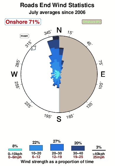
Periodo dominante (s) 6 9 7 7 Overall Roads End Surf Consistency and Wind Distribution in Luglio
foto dall' album
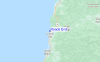
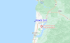
Contorni: Strade e fiumi: seleziona un surf break dal menu 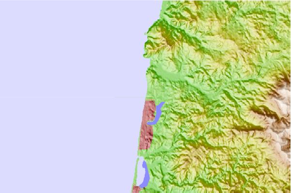
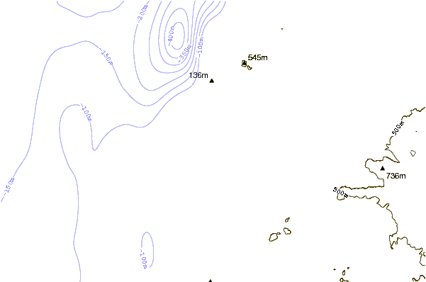
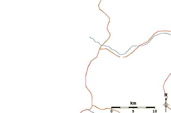
Utilizzare questa mappa sollievo per navigare Oregon North surf breaks e stazioni di marea che si trovano nella zona diRoads End
Altri surf breaks più vicini al Roads End:
(clicca sul nome del luogo per maggiori informazioni)- Closest località surf4 mi
- Second closest località surf4 mi
- Third closest località surf5 mi
- Fourth closest località surf8 mi
- Fifth closest località surf11 mi
Onda boe più vicina a Roads End:
- Closest Onda boa35 mi
- Second closest Onda boa83 mi
- Third closest Onda boa84 mi
- Fourth closest Onda boa85 mi
- Fifth closest Onda boa86 mi
Stazioni di marea più vicina alla Roads End:
- Closest marea stazioneTaft, Siletz Bay4 mi
- Second closest marea stazioneKernville, Siletz River7 mi
- Third closest marea stazioneNestucca Bay entrance12 mi
- Fourth closest marea stazioneDepoe Bay13 mi
- Fifth closest marea stazioneNewport, Yaquina River26 mi
Airports
- The closest passenger airport to Roads End is Mc Minnville Muni (Mackminnville) Airport (MMV) in USA, which is 72 km (45 miles) away (directly).
- The second nearest airport to Roads End is Scappoose Industrial Airpark (San Luis) Airport (SPB), also in USA, 124 km (77 miles) away.
- The third closest airport is Portland International Airport (PDX), also in USA, 129 km (80 miles) away.

- /breaks/Roads-End/forecasts/latest


 Nearest