
Previsioni:

Previsione a breve termineper lo più asciutto. Warm (Max 24°C Venerdì mattina, Min 21°C Venerdì notte). Vento sarà generalmente leggero. | ||||||||||||||||||||||||
Venerdì 17 | Sabato 18 | Domenica 19 | ||||||||||||||||||||||
1 AM | 4 AM | 7 AM | 10 AM | 1 PM | 4 PM | 7 PM | 10 PM | 1 AM | 4 AM | 7 AM | 10 AM | 1 PM | 4 PM | 7 PM | 10 PM | 1 AM | 4 AM | 7 AM | 10 AM | 1 PM | 4 PM | 7 PM | 10 PM | |
Mappa dell'altezza del moto ondoso |  | 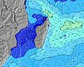 | 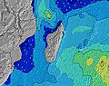 | 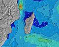 | 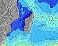 | 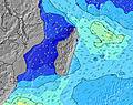 | 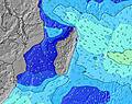 | 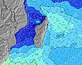 | 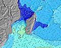 | |||||||||||||||
Onda Altezza (m) Direzione Periodo (s) | S 10 | S 13 | S 17 | WSW 4 | NW 4 | NW 4 | S 15 | S 14 | S 14 | S 14 | S 13 | S 13 | S 13 | SSW 11 | SW 18 | SW 17 | SW 16 | SW 16 | SW 16 | SW 16 | SW 15 | SW 15 | S 5 | S 5 |
Grafico delle onde | ||||||||||||||||||||||||
0 | 0 | 0 | 1 | 7 | 5 | 0 | 0 | 0 | 0 | 0 | 0 | 0 | 0 | 0 | 0 | 0 | 0 | 0 | 0 | 0 | 0 | 7 | 7 | |
Vento (km/h) | ||||||||||||||||||||||||
Stato del vento onshore cross-onshore cross-shore cross-offshore offshore piatto | cross-off | cross-off | cross-off | cross | cross-on | cross | cross | cross-off | glassy | glassy | glassy | cross-on | cross-on | cross-on | on | glassy | glassy | glassy | glassy | on | cross-on | cross-on | glassy | cross-on |
Alta Marea | 2:13AM0.61m | 3:12PM0.52m | 2:47AM0.58m | 3:42PM0.50m | 3:19AM0.52m | 4:10PM0.48m | ||||||||||||||||||
Basso Marea | 8:49AM0.03m | 8:49PM0.19m | 9:22AM0.08m | 9:26PM0.22m | 9:52AM0.14m | |||||||||||||||||||
— | 6:54 | — | — | — | — | — | — | — | 6:54 | — | — | — | — | — | — | — | 6:54 | — | — | — | — | — | — | |
— | — | — | — | — | 5:52 | — | — | — | — | — | — | — | 5:52 | — | — | — | — | — | — | — | 5:52 | — | — | |
mm | 1 | 1 | — | — | — | — | — | — | — | — | — | — | — | — | — | — | — | — | — | — | — | — | — | — |
Temp. °C | 23 | 23 | 23 | 24 | 24 | 23 | 22 | 22 | 21 | 21 | 21 | 23 | 23 | 22 | 22 | 21 | 21 | 21 | 21 | 22 | 23 | 22 | 21 | 21 |
Gelo °C | 25 | 24 | 25 | 25 | 25 | 24 | 24 | 24 | 23 | 22 | 21 | 23 | 23 | 23 | 24 | 23 | 24 | 24 | 23 | 23 | 24 | 23 | 23 | 23 |
Onda 1 Altezza (m) Direzione Periodo (s) | SE 9 | ESE 9 | S 17 | S 17 | S 16 | S 16 | S 15 | S 14 | S 14 | S 14 | S 13 | S 13 | S 13 | SSW 11 | SSW 11 | SSW 10 | SSW 10 | SSW 10 | SW 16 | SW 16 | SW 15 | SW 15 | SW 14 | SW 14 |
61 | 49 | 284 | 443 | 719 | 967 | 804 | 713 | 694 | 577 | 434 | 402 | 324 | 209 | 158 | 195 | 136 | 133 | 361 | 462 | 485 | 479 | 528 | 581 | |
Onda 2 Altezza (m) Direzione Periodo (s) | S 10 | S 10 | S 10 | S 11 | ESE 9 | ESE 8 | SW 5 | SE 8 | SW 5 | SW 5 | SW 5 | SW 5 | SSW 5 | SSW 5 | SW 18 | SW 17 | SW 16 | SW 16 | S 10 | SSW 10 | S 10 | S 9 | SSW 15 | SSW 14 |
71 | 68 | 68 | 108 | 29 | 26 | 12 | 58 | 29 | 23 | 22 | 21 | 17 | 17 | 152 | 186 | 257 | 310 | 70 | 74 | 47 | 45 | 79 | 163 | |
Onda 3 Altezza (m) Direzione Periodo (s) | S 13 | S 13 | ESE 9 | ESE 9 | NW 4 | NW 4 | SE 8 | SW 5 | SE 8 | SE 8 | SE 8 | ESE 8 | SE 8 | SW 18 | SSW 5 | ESE 9 | ESE 8 | ESE 8 | SSW 5 | S 12 | SSW 5 | SSW 5 | SSW 9 | SSE 11 |
56 | 82 | 52 | 50 | 7 | 5 | 33 | 21 | 44 | 42 | 34 | 28 | 18 | 154 | 17 | 15 | 14 | 14 | 8 | 25 | 8 | 8 | 16 | 23 | |
onde vento Altezza (m) Direzione Periodo (s) | NW 4 | NW 4 | WNW 4 | WSW 4 | SW 4 | — | — | — | — | — | — | — | — | — | — | — | — | — | — | — | — | — | S 5 | S 5 |
9 | 12 | 7 | 1 | 2 | — | — | — | — | — | — | — | — | — | — | — | — | — | — | — | — | — | 7 | 7 | |
Il più vicino Offshore or Glassy | ||||||||||||||||||||||||
Distanza (km) | 4 | 4 | 11 | 43 | 43 | 29 | 18 | 4 | 4 | 4 | 4 | 18 | 18 | 18 | 18 | 4 | 4 | 4 | 4 | 18 | 18 | 18 | 4 | 18 |
Migliori previsioni per le condizioni d'onda in Réunion Island | ||||||||||||||||||||||||
Migliori previsioni per le condizioni d'onda in Reunion | ||||||||||||||||||||||||
Trova Onde Globale | ||||||||||||||||||||||||
- Map Icons:
 Break
Break Live Wave Height (m)
 Live Wind Speed (km/h)
 Surf Rating (10 Max)
 Ocean Swells (m)
- Wind Speed (km/h)
Widget Free Surf-Forecast.com per il tuo sito
La relazione di surf / widget meteo è disponibile qui sotto per incorporare su siti esterni a titolo gratuito e fornisce una sintesi delle nostre Saint-Pierre previsione surf. Basta prendere il frammento di codice html da noi fornito e copiarlo nel proprio sito. È possibile scegliere la lingua preferita e unità metriche / imperiali per il feed delle previsioni surf per soddisfare le esigenze degli utenti del vostro sito .... Clicca qui per ottenere il codice.
 Nearest