
Previsioni:

Previsione a breve termineper lo più asciutto. Warm (Max 23°C martedì mattina, Min 14°C Domenica mattina). Vento sarà generalmente leggero. | ||||||||||||||||||||||||
Domenica 19 | Lunedì 20 | Martedì 21 | ||||||||||||||||||||||
2 AM | 5 AM | 8 AM | 11 AM | 2 PM | 5 PM | 8 PM | 11 PM | 2 AM | 5 AM | 8 AM | 11 AM | 2 PM | 5 PM | 8 PM | 11 PM | 2 AM | 5 AM | 8 AM | 11 AM | 2 PM | 5 PM | 8 PM | 11 PM | |
Mappa dell'altezza del moto ondoso |  |  |  |  |  |  |  | 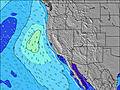 |  | |||||||||||||||
Onda Altezza (m) Direzione Periodo (s) | WNW 16 | WNW 16 | SW 16 | SW 17 | SW 17 | SW 17 | SW 17 | SW 16 | S 12 | SW 16 | S 12 | SSW 16 | SW 16 | SW 16 | SW 16 | SW 16 | SSW 16 | SSW 16 | SSW 17 | SSW 17 | SSW 15 | SSW 14 | SSW 15 | SSW 15 |
Grafico delle onde | ||||||||||||||||||||||||
284 | 215 | 264 | 358 | 439 | 439 | 424 | 326 | 285 | 261 | 280 | 314 | 255 | 362 | 362 | 258 | 397 | 237 | 350 | 657 | 505 | 565 | 422 | 358 | |
Vento (km/h) | ||||||||||||||||||||||||
Stato del vento onshore cross-onshore cross-shore cross-offshore offshore piatto | cross-on | cross-on | glassy | on | on | on | cross-on | on | cross-on | glassy | cross-on | on | on | on | cross-on | cross-on | glassy | glassy | cross-on | on | on | on | cross-on | glassy |
Alta Marea | 2:05AM1.68m | 3:19PM1.88m | 3:16AM1.46m | 4:02PM1.90m | 4:48AM1.30m | 4:47PM1.91m | ||||||||||||||||||
Basso Marea | 8:31AM0.57m | 9:46PM0.88m | 9:08AM0.77m | 11:06PM0.79m | 9:48AM0.96m | |||||||||||||||||||
— | 6:01 | — | — | — | — | — | — | — | 6:03 | — | — | — | — | — | — | — | 6:03 | — | — | — | — | — | — | |
— | — | — | — | — | — | 8:17 | — | — | — | — | — | — | — | 8:16 | — | — | — | — | — | — | — | 8:16 | — | |
mm | — | — | — | — | — | — | — | — | — | — | — | — | — | — | — | — | — | — | — | — | — | — | — | — |
Temp. °C | 15 | 15 | 16 | 19 | 19 | 18 | 15 | 15 | 14 | 15 | 16 | 20 | 21 | 21 | 17 | 17 | 18 | 18 | 20 | 23 | 23 | 22 | 19 | 17 |
Gelo °C | 14 | 14 | 16 | 18 | 18 | 16 | 13 | 14 | 13 | 15 | 15 | 19 | 19 | 18 | 15 | 16 | 17 | 17 | 19 | 22 | 21 | 19 | 17 | 16 |
Onda 1 Altezza (m) Direzione Periodo (s) | WNW 16 | WNW 6 | WNW 6 | SW 17 | SW 17 | SW 17 | S 13 | S 12 | S 12 | S 12 | S 12 | S 11 | S 12 | S 12 | S 11 | S 11 | SSW 16 | S 11 | S 13 | SSW 17 | SSW 15 | SSW 14 | SSW 15 | WNW 6 |
284 | 53 | 48 | 358 | 439 | 439 | 263 | 295 | 285 | 228 | 280 | 151 | 216 | 282 | 255 | 244 | 397 | 146 | 350 | 657 | 505 | 565 | 422 | 115 | |
Onda 2 Altezza (m) Direzione Periodo (s) | SW 16 | WNW 16 | SW 16 | WNW 6 | WNW 16 | S 13 | SW 17 | WNW 9 | WNW 9 | SW 16 | SW 16 | SSW 16 | SW 16 | SW 16 | SW 16 | SW 16 | S 11 | SSW 16 | SSW 17 | S 10 | S 10 | S 17 | SSW 12 | SSW 15 |
124 | 215 | 264 | 37 | 212 | 171 | 424 | 101 | 99 | 261 | 258 | 314 | 255 | 362 | 362 | 258 | 146 | 237 | 321 | 94 | 92 | 147 | 186 | 358 | |
Onda 3 Altezza (m) Direzione Periodo (s) | SSE 11 | SW 16 | WNW 16 | WNW 16 | S 14 | WNW 15 | WNW 15 | SW 16 | SW 16 | WNW 9 | WNW 8 | S 13 | S 14 | WNW 14 | WNW 14 | WNW 14 | WNW 5 | SSW 13 | WNW 5 | WNW 13 | WNW 13 | WNW 13 | WNW 13 | SSW 12 |
43 | 157 | 215 | 215 | 131 | 186 | 184 | 326 | 268 | 86 | 64 | 167 | 132 | 118 | 118 | 116 | 18 | 156 | 31 | 58 | 58 | 57 | 57 | 186 | |
onde vento Altezza (m) Direzione Periodo (s) | WNW 6 | NW 6 | NW 6 | — | WNW 6 | WNW 10 | WNW 9 | NW 5 | — | — | — | WNW 8 | NW 8 | WNW 8 | WNW 4 | WNW 4 | NW 5 | NW 5 | NW 5 | WNW 5 | WNW 5 | WNW 5 | WNW 6 | NW 6 |
66 | 109 | 83 | — | 39 | 145 | 133 | 36 | — | — | — | 47 | 74 | 90 | 14 | 11 | 32 | 38 | 67 | 21 | 50 | 90 | 104 | 219 | |
Il più vicino Offshore or Glassy | ||||||||||||||||||||||||
Distanza (km) | 91 | 23 | 0 | 172 | 174 | 174 | 56 | 91 | 23 | 0 | 56 | 139 | 174 | 174 | 56 | 5 | 0 | 0 | 56 | 161 | 172 | 200 | 56 | 0 |
Migliori previsioni per le condizioni d'onda in San Luis Obispo | ||||||||||||||||||||||||
Migliori previsioni per le condizioni d'onda in United States | ||||||||||||||||||||||||
Trova Onde Globale | ||||||||||||||||||||||||
- Map Icons:
 Break
Break Live Wave Height (m)
 Live Wind Speed (km/h)
 Surf Rating (10 Max)
 Ocean Swells (m)
- Wind Speed (km/h)
Widget Free Surf-Forecast.com per il tuo sito
La relazione di surf / widget meteo è disponibile qui sotto per incorporare su siti esterni a titolo gratuito e fornisce una sintesi delle nostre Santa Rosa Creek previsione surf. Basta prendere il frammento di codice html da noi fornito e copiarlo nel proprio sito. È possibile scegliere la lingua preferita e unità metriche / imperiali per il feed delle previsioni surf per soddisfare le esigenze degli utenti del vostro sito .... Clicca qui per ottenere il codice.
 Nearest