
Previsioni:

Previsione a breve termineper lo più asciutto. Very mild (Max 19°C giovedì pomeriggio, Min 13°C Venerdì notte). Venti in aumento (venti deboli da NW giovedì pomeriggio, raffiche di vento da NNW per sabato pomeriggio). | |||||||||||||||||||||
Gio 16 | Venerdì 17 | Sabato 18 | |||||||||||||||||||
11 AM | 2 PM | 5 PM | 8 PM | 11 PM | 2 AM | 5 AM | 8 AM | 11 AM | 2 PM | 5 PM | 8 PM | 11 PM | 2 AM | 5 AM | 8 AM | 11 AM | 2 PM | 5 PM | 8 PM | 11 PM | |
Mappa dell'altezza del moto ondoso | 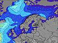 | 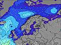 | 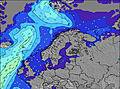 | 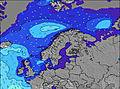 | 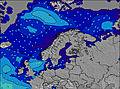 | 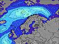 | 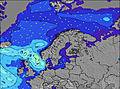 | 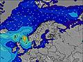 | |||||||||||||
Onda Altezza (m) Direzione Periodo (s) | NW 5 | NW 5 | NW 5 | NW 5 | NW 5 | NW 5 | NW 5 | NW 5 | NW 6 | NW 6 | NW 6 | NW 6 | NW 7 | NW 7 | NW 7 | NW 9 | NW 9 | NW 9 | NW 9 | NW 9 | NW 10 |
Grafico delle onde | |||||||||||||||||||||
6 | 6 | 7 | 8 | 11 | 21 | 21 | 23 | 39 | 66 | 159 | 263 | 248 | 275 | 309 | 943 | 951 | 1002 | 980 | 942 | 1092 | |
Vento (km/h) | |||||||||||||||||||||
Stato del vento onshore cross-onshore cross-shore cross-offshore offshore piatto | cross-on | cross-on | cross-on | cross-on | cross | cross | cross | cross | cross-on | cross-on | cross | cross-on | cross-on | cross | cross-on | cross | cross-on | cross-on | cross-on | cross | cross |
Alta Marea | 1:07PM0.27m | 1:17AM0.36m | 1:45PM0.27m | 1:56AM0.36m | 2:19PM0.27m | ||||||||||||||||
Basso Marea | 6:33PM0.03m | 7:32AM0.01m | 7:18PM0.03m | 8:16AM0.02m | 8:01PM0.03m | ||||||||||||||||
— | — | — | — | — | 4:54 | — | — | — | — | — | — | — | 4:56 | — | — | — | — | — | — | — | |
— | — | — | 10:32 | — | — | — | — | — | — | — | 10:31 | — | — | — | — | — | — | — | 10:30 | — | |
mm | — | — | — | — | — | — | — | — | — | — | — | — | — | — | — | — | — | — | — | — | — |
Temp. °C | 18 | 19 | 19 | 18 | 18 | 16 | 15 | 15 | 15 | 15 | 14 | 13 | 13 | 13 | 13 | 13 | 14 | 14 | 14 | 14 | 14 |
Gelo °C | 17 | 18 | 18 | 16 | 16 | 13 | 13 | 13 | 12 | 10 | 8 | 6 | 7 | 6 | 7 | 8 | 8 | 6 | 6 | 8 | 10 |
Onda 1 Altezza (m) Direzione Periodo (s) | NW 5 | WNW 7 | NW 5 | WNW 8 | WNW 8 | W 9 | W 9 | WNW 13 | WNW 12 | WNW 12 | WNW 11 | WNW 11 | WNW 10 | WNW 10 | W 9 | NW 9 | NW 10 | — | — | — | NW 10 |
6 | 5 | 6 | 7 | 7 | 2 | 2 | 16 | 28 | 44 | 40 | 39 | 35 | 19 | 44 | 715 | 694 | — | — | — | 1092 | |
Onda 2 Altezza (m) Direzione Periodo (s) | W 9 | W 9 | WNW 8 | NW 8 | NW 8 | W 12 | W 13 | WNW 13 | W 8 | W 8 | — | — | — | — | — | WNW 9 | — | — | — | — | — |
6 | 6 | 7 | 3 | 2 | 3 | 3 | 16 | 1 | 1 | — | — | — | — | — | 66 | — | — | — | — | — | |
Onda 3 Altezza (m) Direzione Periodo (s) | WNW 7 | NW 6 | NW 6 | NW 6 | N 8 | — | W 13 | W 9 | W 8 | — | — | — | — | — | — | — | — | — | — | — | — |
5 | 2 | 2 | 1 | 1 | — | 3 | 2 | 1 | — | — | — | — | — | — | — | — | — | — | — | — | |
onde vento Altezza (m) Direzione Periodo (s) | — | NW 5 | — | NW 5 | NW 5 | NW 5 | NW 5 | NW 5 | NW 6 | NW 6 | NW 6 | NW 6 | NW 7 | NW 7 | NW 7 | NW 9 | NW 9 | NW 9 | NW 9 | NW 9 | — |
— | 6 | — | 8 | 11 | 21 | 21 | 23 | 39 | 66 | 159 | 263 | 248 | 275 | 309 | 943 | 951 | 1002 | 980 | 942 | — | |
Il più vicino Offshore or Glassy | |||||||||||||||||||||
Distanza (km) | 472 | 509 | 509 | 409 | 513 | 596 | 617 | 472 | 617 | 1137 | 1137 | 750 | 565 | 527 | 472 | 544 | 588 | 588 | 584 | 596 | 497 |
Migliori previsioni per le condizioni d'onda in South and West Norway | |||||||||||||||||||||
Migliori previsioni per le condizioni d'onda in Norway | |||||||||||||||||||||
Trova Onde Globale | |||||||||||||||||||||
- Map Icons:
 Break
Break Live Wave Height (m)
 Live Wind Speed (km/h)
 Surf Rating (10 Max)
 Ocean Swells (m)
- Wind Speed (km/h)
Widget Free Surf-Forecast.com per il tuo sito
La relazione di surf / widget meteo è disponibile qui sotto per incorporare su siti esterni a titolo gratuito e fornisce una sintesi delle nostre Sele previsione surf. Basta prendere il frammento di codice html da noi fornito e copiarlo nel proprio sito. È possibile scegliere la lingua preferita e unità metriche / imperiali per il feed delle previsioni surf per soddisfare le esigenze degli utenti del vostro sito .... Clicca qui per ottenere il codice.
 Nearest