
Previsioni:

Previsione a breve termineper lo più asciutto. Warm (Max 29°C Venerdì mattina, Min 26°C giovedì mattina). Venti in aumento (venti deboli da O giovedì mattina, venti freschi da SW per sabato notte). | ||||||||||||||||||||||||
Giovedì 16 | Venerdì 17 | Sabato 18 | ||||||||||||||||||||||
2 AM | 5 AM | 8 AM | 11 AM | 2 PM | 5 PM | 8 PM | 11 PM | 2 AM | 5 AM | 8 AM | 11 AM | 2 PM | 5 PM | 8 PM | 11 PM | 2 AM | 5 AM | 8 AM | 11 AM | 2 PM | 5 PM | 8 PM | 11 PM | |
Mappa dell'altezza del moto ondoso | 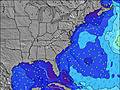 | 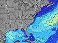 | 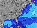 | 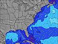 | 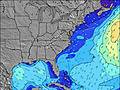 | 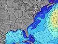 | 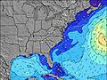 | 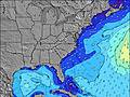 | 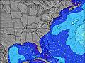 | |||||||||||||||
Onda Altezza (m) Direzione Periodo (s) | SE 8 | SE 8 | SE 8 | SE 8 | SE 8 | SE 8 | SE 8 | SE 8 | SE 8 | SE 8 | SE 8 | SE 8 | SE 8 | SE 8 | SE 8 | SE 8 | SE 8 | SE 8 | SE 8 | SE 8 | ESE 8 | SSW 4 | SSW 5 | SSW 6 |
Grafico delle onde | ||||||||||||||||||||||||
16 | 16 | 16 | 16 | 15 | 15 | 16 | 16 | 12 | 12 | 11 | 11 | 17 | 17 | 17 | 17 | 17 | 17 | 17 | 17 | 13 | 28 | 52 | 131 | |
Vento (km/h) | ||||||||||||||||||||||||
Stato del vento onshore cross-onshore cross-shore cross-offshore offshore piatto | cross-on | cross-on | cross-on | on | on | on | on | on | cross-on | cross-on | cross-on | on | on | on | on | on | on | on | on | on | on | on | on | on |
Alta Marea | 11:07AM0.68m | 11:29PM0.75m | 11:58AM0.69m | 00:17AM0.70m | 12:49PM0.69m | |||||||||||||||||||
Basso Marea | 5:01AM-0.08m | 5:10PM-0.06m | 5:47AM-0.07m | 6:04PM-0.03m | 6:32AM-0.05m | 6:59PM0.00m | ||||||||||||||||||
— | 6:03 | — | — | — | — | — | — | — | 6:05 | — | — | — | — | — | — | — | 6:05 | — | — | — | — | — | — | |
— | — | — | — | — | — | 8:19 | — | — | — | — | — | — | — | 8:19 | — | — | — | — | — | — | — | 8:17 | — | |
mm | — | — | — | — | — | — | — | — | — | — | — | — | — | — | — | — | — | — | — | — | — | — | — | — |
Temp. °C | 27 | 26 | 26 | 27 | 28 | 28 | 28 | 28 | 27 | 27 | 28 | 29 | 29 | 29 | 28 | 28 | 28 | 27 | 27 | 28 | 28 | 28 | 28 | 28 |
Gelo °C | 30 | 29 | 30 | 30 | 30 | 29 | 30 | 30 | 30 | 30 | 31 | 31 | 31 | 30 | 31 | 30 | 31 | 30 | 30 | 30 | 29 | 29 | 28 | 28 |
Onda 1 Altezza (m) Direzione Periodo (s) | SE 8 | SE 8 | SE 8 | SE 8 | SE 8 | SE 8 | SE 8 | SE 8 | SE 8 | SE 8 | SE 8 | SE 8 | SE 8 | SE 8 | SE 8 | SE 8 | SE 8 | SE 8 | SE 8 | SE 8 | ESE 8 | ESE 8 | ESE 8 | SE 13 |
16 | 16 | 16 | 16 | 15 | 15 | 16 | 16 | 10 | 10 | 11 | 11 | 17 | 17 | 17 | 17 | 17 | 17 | 17 | 17 | 13 | 6 | 6 | 7 | |
Onda 2 Altezza (m) Direzione Periodo (s) | E 7 | E 6 | E 5 | E 5 | E 6 | E 6 | E 6 | E 6 | E 6 | E 6 | E 6 | E 6 | E 5 | E 14 | E 14 | SE 14 | SE 14 | SE 14 | SE 13 | SE 13 | SE 13 | SE 13 | SE 13 | E 9 |
8 | 5 | 5 | 5 | 7 | 3 | 3 | 3 | 3 | 3 | 1 | 1 | 1 | 4 | 4 | 8 | 7 | 7 | 7 | 7 | 7 | 7 | 7 | 2 | |
Onda 3 Altezza (m) Direzione Periodo (s) | ESE 6 | SW 5 | SW 4 | SW 4 | — | E 15 | SE 15 | SE 15 | SE 15 | SE 15 | SE 15 | E 14 | E 14 | E 14 | E 7 | SE 14 | E 7 | SE 14 | E 9 | E 9 | E 9 | E 9 | E 9 | — |
3 | 1 | 1 | 1 | — | 4 | 9 | 9 | 8 | 8 | 8 | 4 | 4 | 4 | 1 | 8 | 1 | 7 | 1 | 1 | 1 | 2 | 2 | — | |
onde vento Altezza (m) Direzione Periodo (s) | SSW 5 | SW 2 | WSW 3 | WSW 3 | SW 2 | SSW 3 | SSW 3 | SSW 4 | SW 4 | SW 4 | SW 4 | SW 4 | SW 4 | SW 4 | SW 4 | SW 4 | SW 4 | SW 4 | SW 4 | SSW 4 | SSW 4 | SSW 4 | SSW 5 | SSW 6 |
2 | 1 | 1 | 1 | 2 | 3 | 7 | 9 | 12 | 12 | 10 | 7 | 11 | 16 | 14 | 14 | 14 | 12 | 13 | 11 | 10 | 28 | 52 | 131 | |
Il più vicino Offshore or Glassy | ||||||||||||||||||||||||
Distanza (km) | 219 | 803 | 803 | 1035 | 908 | 908 | 722 | 438 | 1747 | 1442 | 1442 | 2135 | 1442 | 1479 | 942 | 822 | 906 | 815 | 836 | 2657 | 2310 | 470 | 378 | 241 |
Migliori previsioni per le condizioni d'onda in North Carolina | ||||||||||||||||||||||||
Migliori previsioni per le condizioni d'onda in United States | ||||||||||||||||||||||||
Trova Onde Globale | ||||||||||||||||||||||||
- Map Icons:
 Break
Break Live Wave Height (m)
 Live Wind Speed (km/h)
 Surf Rating (10 Max)
 Ocean Swells (m)
- Wind Speed (km/h)
Widget Free Surf-Forecast.com per il tuo sito
La relazione di surf / widget meteo è disponibile qui sotto per incorporare su siti esterni a titolo gratuito e fornisce una sintesi delle nostre Shackleford Banks previsione surf. Basta prendere il frammento di codice html da noi fornito e copiarlo nel proprio sito. È possibile scegliere la lingua preferita e unità metriche / imperiali per il feed delle previsioni surf per soddisfare le esigenze degli utenti del vostro sito .... Clicca qui per ottenere il codice.
 Nearest