

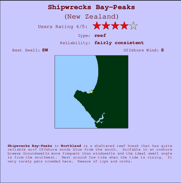
Shipwrecks Bay-Peaks Surf Guide
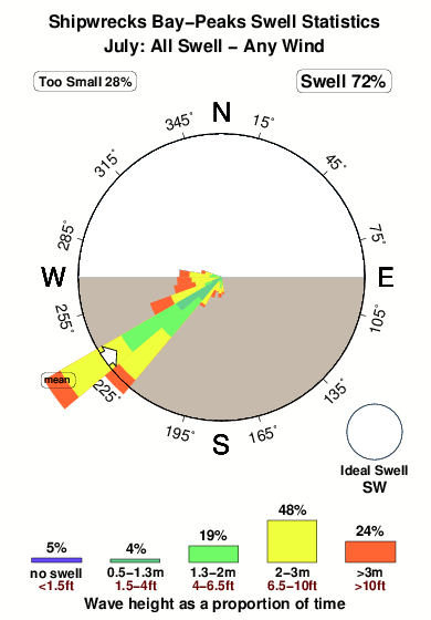
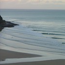
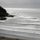
Shipwrecks Bay-Peaks in Northland is a sheltered reef break that has quite reliable surf The best wind direction is from the south. Surfable in an onshore breeze Tends to receive distant groundswells and the best swell direction is from the southwest. A left hand reef. Best around low tide when the tide is rising. Rarely crowded here. Beware of rips and rocks.
Shipwrecks Bay-Peaks Spot Info
| Type: | Rating: | Reliability: | Todays Sea Temp*: |
|---|---|---|---|
| fairly consistent | 15.6°C*ocean temperature recorded from satellite |
Surfing Shipwrecks Bay-Peaks:
The best conditions reported for surf at Shipwrecks Bay-Peaks occur when a Southwest swell combines with an offshore wind direction from the South.

Previsioni Energia d'onda (Potenza): 12hrs


Shipwrecks Bay-Peaks Surf:
Friday, 17 July 2026, 03:53 Local time| Venerdì 17 | ||||
| 3AM | 6AM | 9AM | 12PM | |
| Wave (m) | ||||
| Periodo (s) | 15 | 15 | 15 | 15 |
| Vento (km/h) | ||||
| Stato del vento | off | off | off | off |
- /breaks/Shipwrecks-Bay-Peaks/forecasts/latest
Shipwrecks Bay-Peaks Surf Guide
Shipwrecks Bay-Peaks in Northland is a sheltered reef break that has quite reliable surf The best wind direction is from the south. Surfable in an onshore breeze Tends to receive distant groundswells and the best swell direction is from the southwest. A left hand reef. Best around low tide when the tide is rising. Rarely crowded here. Beware of rips and rocks.
Shipwrecks Bay-Peaks Spot Info
Type: Rating: Reliability: Todays Sea Temp*:  Reef
Reef 4
4fairly consistent 15.6°C*ocean temperature recorded from satelliteSurfing Shipwrecks Bay-Peaks:
The best conditions reported for surf at Shipwrecks Bay-Peaks occur when a Southwest swell combines with an offshore wind direction from the South.
Previsioni Energia d'onda (Potenza): 12hrs
Utilizzare la scheda di navigazione in alto per visualizzare Shipwrecks Bay-Peaks temperatura del mare, Shipwrecks Bay-Peaks fotografie, Shipwrecks Bay-Peaks dettagliate previsioni onde, il vento e le previsioni meteo, Shipwrecks Bay-Peaks webcam, vento corrente da Northland stazioni meteo e Shipwrecks Bay-Peaks previsioni marea. Il link New Zealand mappe maree apre l'immagine grande, che mostra New Zealand e dei mari circostanti. Queste mappe possono essere animate per mostrare le diverse componenti del moto ondoso, energia delle onde, periodo d'onda, altezza delle onde, insieme con le previsioni del vento e meteo, meteo corrente e osservazioni sullo stato del mare dal New Zealand onda-boe, le navi passanti e stazioni meteo costiere. Ciascuna delle pagine di previsioni per questo surf break rappresenta uno strumento di wavefinder globale e regionale per individuare le migliori condizioni di surf nella zona intorno Shipwrecks Bay-Peaks.
Shipwrecks Bay-Peaks Surf:
Friday, 17 July 2026, 03:53 Local timeVenerdì 17 3AM 6AM 9AM 12PM Wave (m) Periodo (s) 15 15 15 15 Vento (km/h) Stato del vento off off off off - /breaks/Shipwrecks-Bay-Peaks/forecasts/latest
- /breaks/Shipwrecks-Bay-Peaks/forecasts/latest/six_day
Shipwrecks Bay-Peaks Surf Guide
Shipwrecks Bay-Peaks in Northland is a sheltered reef break that has quite reliable surf The best wind direction is from the south. Surfable in an onshore breeze Tends to receive distant groundswells and the best swell direction is from the southwest. A left hand reef. Best around low tide when the tide is rising. Rarely crowded here. Beware of rips and rocks.
Shipwrecks Bay-Peaks Spot Info
Type: Rating: Reliability: Todays Sea Temp*: Reef4fairly consistent 15.6°C*ocean temperature recorded from satelliteSurfing Shipwrecks Bay-Peaks:
The best conditions reported for surf at Shipwrecks Bay-Peaks occur when a Southwest swell combines with an offshore wind direction from the South.
Previsioni Energia d'onda (Potenza): 12hrs
Utilizzare la scheda di navigazione in alto per visualizzare Shipwrecks Bay-Peaks temperatura del mare, Shipwrecks Bay-Peaks fotografie, Shipwrecks Bay-Peaks dettagliate previsioni onde, il vento e le previsioni meteo, Shipwrecks Bay-Peaks webcam, vento corrente da Northland stazioni meteo e Shipwrecks Bay-Peaks previsioni marea. Il link New Zealand mappe maree apre l'immagine grande, che mostra New Zealand e dei mari circostanti. Queste mappe possono essere animate per mostrare le diverse componenti del moto ondoso, energia delle onde, periodo d'onda, altezza delle onde, insieme con le previsioni del vento e meteo, meteo corrente e osservazioni sullo stato del mare dal New Zealand onda-boe, le navi passanti e stazioni meteo costiere. Ciascuna delle pagine di previsioni per questo surf break rappresenta uno strumento di wavefinder globale e regionale per individuare le migliori condizioni di surf nella zona intorno Shipwrecks Bay-Peaks.
Shipwrecks Bay-Peaks Surf:
Friday, 17 July 2026, 03:53 Local timeVenerdì 17 3AM 6AM 9AM 12PM Wave (m) Periodo (s) 15 15 15 15 Vento (km/h) Stato del vento off off off off - /breaks/Shipwrecks-Bay-Peaks/forecasts/latest
Shipwrecks Bay-Peaks Surf Guide
Shipwrecks Bay-Peaks in Northland is a sheltered reef break that has quite reliable surf The best wind direction is from the south. Surfable in an onshore breeze Tends to receive distant groundswells and the best swell direction is from the southwest. A left hand reef. Best around low tide when the tide is rising. Rarely crowded here. Beware of rips and rocks.
Shipwrecks Bay-Peaks Spot Info
Type: Rating: Reliability: Todays Sea Temp*: Reef4fairly consistent 15.6°C*ocean temperature recorded from satelliteSurfing Shipwrecks Bay-Peaks:
The best conditions reported for surf at Shipwrecks Bay-Peaks occur when a Southwest swell combines with an offshore wind direction from the South.
Previsioni Energia d'onda (Potenza): 12hrs
Utilizzare la scheda di navigazione in alto per visualizzare Shipwrecks Bay-Peaks temperatura del mare, Shipwrecks Bay-Peaks fotografie, Shipwrecks Bay-Peaks dettagliate previsioni onde, il vento e le previsioni meteo, Shipwrecks Bay-Peaks webcam, vento corrente da Northland stazioni meteo e Shipwrecks Bay-Peaks previsioni marea. Il link New Zealand mappe maree apre l'immagine grande, che mostra New Zealand e dei mari circostanti. Queste mappe possono essere animate per mostrare le diverse componenti del moto ondoso, energia delle onde, periodo d'onda, altezza delle onde, insieme con le previsioni del vento e meteo, meteo corrente e osservazioni sullo stato del mare dal New Zealand onda-boe, le navi passanti e stazioni meteo costiere. Ciascuna delle pagine di previsioni per questo surf break rappresenta uno strumento di wavefinder globale e regionale per individuare le migliori condizioni di surf nella zona intorno Shipwrecks Bay-Peaks.
Shipwrecks Bay-Peaks Surf:
Friday, 17 July 2026, 03:53 Local timeVenerdì 17 3AM 6AM 9AM 12PM Wave (m) Periodo (s) 15 15 15 15 Vento (km/h) Stato del vento off off off off Tide Times:
Per Ahipara Bay, New Zealand, %{dist} %{km} da %{location}.
PROSSIMA È ALLE (ora locale) rimanente alta marea bassa marea Shipwrecks Bay-Peaks Tide Times and Tide Chart
Live Weather:
At Kaitaia Airport, 18 km from Shipwrecks Bay-Peaks.
light winds from the S
(km/h)
DryAir temperature
8.4°COverall Shipwrecks Bay-Peaks Surf Consistency and Wind Distribution in Luglio


Wind stats for Shipwrecks Bay-Peaks: see the variation in direction and stength by month.
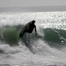
foto dall' album
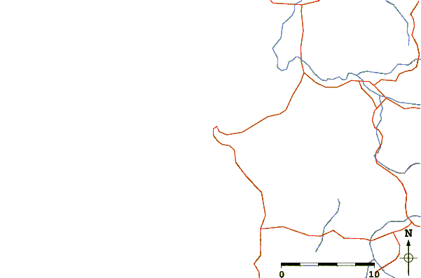
Contorni: Strade e fiumi: seleziona un surf break dal menu 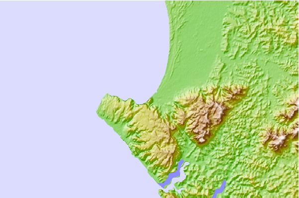
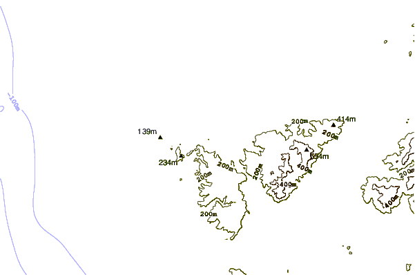
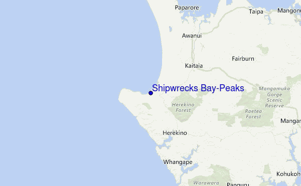
Utilizzare questa mappa sollievo per navigare Northland surf breaks e stazioni di marea che si trovano nella zona diShipwrecks Bay-Peaks
Altri surf breaks più vicini al Shipwrecks Bay-Peaks:
(clicca sul nome del luogo per maggiori informazioni)- Closest località surf1 mi
- Second closest località surf1 mi
- Third closest località surf2 mi
- Fourth closest località surf2 mi
- Fifth closest località surf4 mi
Onda boe più vicina a Shipwrecks Bay-Peaks:
- Closest Onda boa93 mi
- Second closest Onda boa260 mi
- Third closest Onda boa381 mi
- Fourth closest Onda boa421 mi
- Fifth closest Onda boa422 mi
Stazioni di marea più vicina alla Shipwrecks Bay-Peaks:
- Closest marea stazioneAhipara Bay2 mi
- Second closest marea stazioneDairy Factory Wharf11 mi
- Third closest marea stazioneOmaia Island14 mi
- Fourth closest marea stazioneSheigis Beacon21 mi
- Fifth closest marea stazioneHouhora River Entrance24 mi
Airports
- The closest passenger airport to Shipwrecks Bay-Peaks is Kaitaia Airport (KAT) in New Zealand, which is 17 km (11 miles) away (directly).
- The second nearest airport to Shipwrecks Bay-Peaks is Kerikeri Airport (KKE), also in New Zealand, 71 km (44 miles) away.
- The third closest airport is Whangarei Airport (WRE), also in New Zealand, 129 km (80 miles) away.
- /breaks/Shipwrecks-Bay-Peaks/forecasts/latest

 Nearest