
Previsioni:

Previsione a breve terminePioggia moderata (Totale 17mm), più pesante Domenica mattina. Warm (Max 26°C Venerdì pomeriggio, Min 25°C Sabato notte). Vento sarà generalmente leggero. | |||||||||||||||||||
Ven 24 | Sabato 25 | Domenica 26 | |||||||||||||||||
4 PM | 7 PM | 10 PM | 1 AM | 4 AM | 7 AM | 10 AM | 1 PM | 4 PM | 7 PM | 10 PM | 1 AM | 4 AM | 7 AM | 10 AM | 1 PM | 4 PM | 7 PM | 10 PM | |
Mappa dell'altezza del moto ondoso |  |  |  | 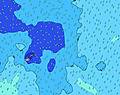 | 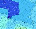 |  | 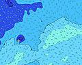 | ||||||||||||
Onda Altezza (m) Direzione Periodo (s) | NE 9 | NE 9 | SW 15 | SW 15 | SW 15 | SW 15 | SW 15 | SW 14 | SW 14 | SW 13 | SW 13 | SW 13 | SW 13 | SW 13 | SW 12 | SW 12 | SW 19 | SW 19 | SW 18 |
Grafico delle onde | |||||||||||||||||||
20 | 19 | 35 | 36 | 36 | 76 | 75 | 74 | 71 | 63 | 62 | 61 | 61 | 60 | 54 | 53 | 131 | 231 | 311 | |
Vento (km/h) | |||||||||||||||||||
Stato del vento onshore cross-onshore cross-shore cross-offshore offshore piatto | off | off | off | off | off | off | off | off | off | off | off | off | off | off | off | cross-off | cross-off | cross-off | cross-off |
Alta Marea | 4:05PM0.78m | 4:16AM0.92m | 4:46PM0.80m | 4:57AM0.94m | 5:26PM0.82m | ||||||||||||||
Basso Marea | 9:59PM0.29m | 10:46AM0.23m | 10:39PM0.27m | 11:23AM0.20m | |||||||||||||||
— | — | — | — | 6:47 | — | — | — | — | — | — | — | 6:46 | — | — | — | — | — | — | |
6:12 | — | — | — | — | — | — | — | 6:12 | — | — | — | — | — | — | — | 6:12 | — | — | |
mm | — | — | — | — | — | — | — | 1 | 2 | 1 | — | 2 | 2 | 2 | 1 | — | — | — | 2 |
Temp. °C | 26 | 26 | 26 | 26 | 26 | 26 | 26 | 26 | 26 | 26 | 26 | 25 | 26 | 26 | 26 | 26 | 26 | 26 | 26 |
Gelo °C | 26 | 26 | 26 | 26 | 26 | 26 | 27 | 27 | 27 | 27 | 27 | 26 | 27 | 27 | 27 | 27 | 28 | 28 | 29 |
Onda 1 Altezza (m) Direzione Periodo (s) | S 13 | S 13 | S 12 | S 12 | S 13 | S 13 | S 13 | S 13 | S 13 | S 12 | S 12 | S 12 | S 12 | S 12 | S 12 | S 13 | S 13 | S 13 | S 12 |
782 | 822 | 775 | 874 | 928 | 958 | 958 | 835 | 826 | 692 | 660 | 393 | 556 | 574 | 505 | 556 | 556 | 475 | 453 | |
Onda 2 Altezza (m) Direzione Periodo (s) | NE 9 | NE 9 | NE 8 | NE 8 | NE 8 | SW 15 | SW 15 | SW 14 | SW 14 | SW 13 | SW 13 | SSE 14 | SW 13 | SW 13 | SW 12 | SW 12 | SW 19 | E 5 | E 6 |
20 | 19 | 18 | 18 | 18 | 76 | 75 | 74 | 71 | 63 | 62 | 254 | 61 | 60 | 54 | 53 | 131 | 47 | 39 | |
Onda 3 Altezza (m) Direzione Periodo (s) | SE 10 | SE 10 | SW 15 | SW 15 | SW 15 | NE 8 | NE 8 | NE 8 | NE 8 | SE 16 | SE 16 | SW 13 | SE 16 | NE 8 | NE 8 | NE 8 | SW 12 | SW 19 | SW 18 |
16 | 16 | 35 | 36 | 36 | 18 | 18 | 17 | 17 | 66 | 64 | 61 | 63 | 15 | 15 | 14 | 37 | 231 | 311 | |
onde vento Altezza (m) Direzione Periodo (s) | ESE 7 | ESE 7 | ESE 6 | E 6 | E 6 | E 6 | E 6 | E 6 | E 6 | E 6 | E 6 | E 6 | E 5 | E 5 | E 5 | E 5 | E 5 | — | — |
111 | 121 | 98 | 92 | 76 | 79 | 69 | 64 | 64 | 64 | 61 | 59 | 46 | 46 | 43 | 41 | 41 | — | — | |
Il più vicino Offshore or Glassy | |||||||||||||||||||
Distanza (km) | 4 | 174 | 174 | 4 | 4 | 0 | 0 | 0 | 0 | 0 | 0 | 0 | 0 | 0 | 0 | 15 | 0 | 0 | 0 |
Migliori previsioni per le condizioni d'onda in American-Samoa - Tutuila | |||||||||||||||||||
Migliori previsioni per le condizioni d'onda in American Samoa | |||||||||||||||||||
Trova Onde Globale | |||||||||||||||||||
- Map Icons:
 Break
Break Live Wave Height (m)
 Live Wind Speed (km/h)
 Surf Rating (10 Max)
 Ocean Swells (m)
- Wind Speed (km/h)
Widget Free Surf-Forecast.com per il tuo sito
La relazione di surf / widget meteo è disponibile qui sotto per incorporare su siti esterni a titolo gratuito e fornisce una sintesi delle nostre Sliding Rock previsione surf. Basta prendere il frammento di codice html da noi fornito e copiarlo nel proprio sito. È possibile scegliere la lingua preferita e unità metriche / imperiali per il feed delle previsioni surf per soddisfare le esigenze degli utenti del vostro sito .... Clicca qui per ottenere il codice.
 Nearest