
Previsioni:

Previsione a breve termineQualche pioggerella, più pesante durante mercoledì notte. Warm (Max 28°C martedì notte, Min 26°C martedì notte). Principalmente venti freschi. | ||||||||||||||||||||||||
Mar 14 | Mercoledì 15 | Giovedì 16 | Ven 17 | |||||||||||||||||||||
5 PM | 8 PM | 11 PM | 2 AM | 5 AM | 8 AM | 11 AM | 2 PM | 5 PM | 8 PM | 11 PM | 2 AM | 5 AM | 8 AM | 11 AM | 2 PM | 5 PM | 8 PM | 11 PM | 2 AM | 5 AM | 8 AM | 11 AM | 2 PM | |
Mappa dell'altezza del moto ondoso |  |  |  |  |  |  |  |  | 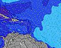 | |||||||||||||||
Onda Altezza (m) Direzione Periodo (s) | E 8 | E 8 | E 8 | E 8 | E 7 | E 7 | E 7 | E 7 | E 7 | E 7 | E 7 | E 7 | E 7 | E 7 | E 7 | E 7 | E 7 | E 7 | E 7 | E 7 | E 7 | E 7 | E 7 | E 7 |
Grafico delle onde | ||||||||||||||||||||||||
164 | 187 | 186 | 186 | 181 | 156 | 155 | 130 | 126 | 150 | 152 | 152 | 184 | 192 | 179 | 154 | 154 | 134 | 162 | 153 | 153 | 153 | 153 | 150 | |
Vento (km/h) | ||||||||||||||||||||||||
Stato del vento onshore cross-onshore cross-shore cross-offshore offshore piatto | cross-on | cross-on | cross-on | cross-on | cross | cross | cross-on | cross-on | cross-on | cross-on | cross-on | cross-on | cross-on | cross | cross | cross | cross | cross | cross-on | cross | cross | cross-on | cross-on | cross-on |
Alta Marea | 8:37PM0.46m | 4:36AM0.42m | 9:03PM0.43m | 6:04AM0.39m | 9:25PM0.40m | 7:33AM0.34m | ||||||||||||||||||
Basso Marea | 1:50AM0.40m | 1:41PM-0.19m | 2:36AM0.33m | 2:28PM-0.10m | 3:29AM0.26m | |||||||||||||||||||
— | — | — | — | 5:43 | — | — | — | — | — | — | — | 5:43 | — | — | — | — | — | — | — | 5:43 | — | — | — | |
6:50 | — | — | — | — | — | — | — | 6:50 | — | — | — | — | — | — | — | 6:50 | — | — | — | — | — | — | 6:50 | |
mm | — | — | — | — | — | — | — | — | — | — | — | — | 1 | — | — | — | — | — | — | — | — | — | — | — |
Temp. °C | 27 | 28 | 27 | 26 | 26 | 27 | 27 | 27 | 27 | 26 | 26 | 26 | 26 | 26 | 26 | 26 | 26 | 26 | 26 | 26 | 26 | 26 | 26 | 26 |
Gelo °C | 26 | 26 | 25 | 25 | 24 | 26 | 26 | 26 | 26 | 25 | 25 | 26 | 25 | 25 | 25 | 26 | 25 | 26 | 25 | 24 | 25 | 26 | 25 | 25 |
Onda 1 Altezza (m) Direzione Periodo (s) | NNE 10 | NNE 10 | NNE 10 | N 10 | N 10 | N 10 | N 9 | NW 8 | NNW 8 | NW 7 | NW 7 | NW 7 | NW 7 | NNW 8 | NNW 8 | NNW 8 | NNW 8 | N 8 | N 7 | N 7 | N 7 | NNE 9 | NNE 8 | NNE 8 |
10 | 10 | 10 | 8 | 8 | 7 | 7 | 2 | 6 | 2 | 2 | 2 | 2 | 7 | 6 | 6 | 11 | 5 | 9 | 9 | 8 | 7 | 14 | 13 | |
Onda 2 Altezza (m) Direzione Periodo (s) | NW 8 | NW 8 | NW 8 | NW 8 | NW 8 | NW 8 | NW 8 | N 9 | N 9 | N 9 | N 9 | N 9 | N 8 | NW 7 | N 9 | N 9 | E 13 | NNW 8 | E 13 | NE 9 | NNE 9 | NNW 7 | NNW 7 | NNW 7 |
3 | 2 | 2 | 2 | 2 | 2 | 2 | 6 | 6 | 2 | 2 | 2 | 1 | 2 | 2 | 2 | 3 | 6 | 3 | 3 | 8 | 5 | 5 | 5 | |
Onda 3 Altezza (m) Direzione Periodo (s) | N 7 | N 6 | N 6 | N 6 | N 6 | N 6 | — | — | E 13 | E 13 | N 6 | N 9 | N 9 | N 9 | E 13 | E 13 | E 13 | E 13 | E 13 | E 13 | E 12 | N 7 | E 12 | E 12 |
1 | 1 | 1 | 1 | 1 | 1 | — | — | 4 | 4 | 1 | 2 | 2 | 2 | 3 | 3 | 3 | 3 | 3 | 3 | 3 | 4 | 3 | 3 | |
onde vento Altezza (m) Direzione Periodo (s) | E 8 | E 8 | E 8 | E 8 | E 7 | E 7 | E 7 | E 7 | E 7 | E 7 | E 7 | E 7 | E 7 | E 7 | E 7 | E 7 | E 7 | E 7 | E 7 | E 7 | E 7 | E 7 | E 7 | E 7 |
164 | 187 | 186 | 186 | 181 | 156 | 155 | 130 | 126 | 150 | 152 | 152 | 184 | 192 | 179 | 154 | 154 | 134 | 162 | 153 | 153 | 153 | 153 | 150 | |
Il più vicino Offshore or Glassy | ||||||||||||||||||||||||
Distanza (km) | 660 | 660 | 214 | 214 | 334 | 4 | 4 | 4 | 214 | 214 | 214 | 214 | 140 | 213 | 140 | 926 | 191 | 646 | 214 | 660 | 348 | 406 | 926 | 191 |
Migliori previsioni per le condizioni d'onda in Saint Barthélemy | ||||||||||||||||||||||||
Migliori previsioni per le condizioni d'onda in Saint Barthélemy | ||||||||||||||||||||||||
Trova Onde Globale | ||||||||||||||||||||||||
- Map Icons:
 Break
Break Live Wave Height (m)
 Live Wind Speed (km/h)
 Surf Rating (10 Max)
 Ocean Swells (m)
- Wind Speed (km/h)
Widget Free Surf-Forecast.com per il tuo sito
La relazione di surf / widget meteo è disponibile qui sotto per incorporare su siti esterni a titolo gratuito e fornisce una sintesi delle nostre St-Jean previsione surf. Basta prendere il frammento di codice html da noi fornito e copiarlo nel proprio sito. È possibile scegliere la lingua preferita e unità metriche / imperiali per il feed delle previsioni surf per soddisfare le esigenze degli utenti del vostro sito .... Clicca qui per ottenere il codice.
 Nearest