
Previsioni:

Previsione a breve termineper lo più asciutto. Very mild (Max 16°C Sabato pomeriggio, Min 12°C giovedì notte). Vento sarà generalmente leggero. | ||||||||||||||||||
Gio 23 | Venerdì 24 | Sabato 25 | ||||||||||||||||
8 PM | 11 PM | 2 AM | 5 AM | 8 AM | 11 AM | 2 PM | 5 PM | 8 PM | 11 PM | 2 AM | 5 AM | 8 AM | 11 AM | 2 PM | 5 PM | 8 PM | 11 PM | |
Mappa dell'altezza del moto ondoso |  |  | 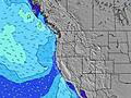 |  |  | 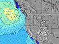 |  | |||||||||||
Onda Altezza (m) Direzione Periodo (s) | SSW 14 | SSW 14 | SW 26 | SW 26 | SW 26 | SW 26 | SW 24 | SW 24 | SW 24 | SW 24 | SW 24 | SW 23 | SW 22 | SW 21 | SW 21 | SW 21 | SW 21 | SW 21 |
Grafico delle onde | ||||||||||||||||||
236 | 233 | 421 | 421 | 237 | 229 | 448 | 780 | 780 | 661 | 444 | 433 | 770 | 1015 | 1167 | 898 | 890 | 749 | |
Vento (km/h) | ||||||||||||||||||
Stato del vento onshore cross-onshore cross-shore cross-offshore offshore piatto | glassy | glassy | glassy | glassy | glassy | on | on | on | glassy | cross-off | cross-off | cross-off | cross | on | on | on | glassy | cross-off |
Alta Marea | 7:38PM1.97m | 10:19AM1.38m | 8:31PM1.98m | 11:11AM1.46m | 9:22PM2.01m | |||||||||||||
Basso Marea | 3:20AM0.16m | 2:23PM1.14m | 4:11AM0.06m | 3:27PM1.15m | ||||||||||||||
— | — | — | 6:01 | — | — | — | — | — | — | — | 6:03 | — | — | — | — | — | — | |
8:45 | — | — | — | — | — | — | — | 8:44 | — | — | — | — | — | — | — | 8:43 | — | |
mm | — | — | — | — | — | — | — | — | — | — | — | — | — | — | — | — | — | — |
Temp. °C | 13 | 12 | 12 | 12 | 13 | 14 | 15 | 15 | 14 | 13 | 13 | 13 | 14 | 15 | 16 | 16 | 15 | 15 |
Gelo °C | 13 | 12 | 12 | 12 | 13 | 13 | 14 | 14 | 14 | 12 | 12 | 12 | 13 | 13 | 15 | 15 | 15 | 15 |
Onda 1 Altezza (m) Direzione Periodo (s) | NW 9 | NW 9 | NW 9 | NW 9 | NW 9 | NW 9 | NW 9 | NW 9 | NNW 9 | NNW 9 | NW 9 | NW 9 | SW 22 | SW 21 | SW 21 | SW 21 | SW 21 | SW 21 |
135 | 135 | 162 | 162 | 162 | 166 | 166 | 162 | 145 | 141 | 115 | 112 | 770 | 1015 | 1167 | 898 | 890 | 749 | |
Onda 2 Altezza (m) Direzione Periodo (s) | SSW 14 | SSW 14 | SSW 14 | SSW 14 | SSW 14 | SSW 13 | SSW 13 | SW 24 | SW 24 | SW 24 | SSW 13 | SSW 13 | NW 9 | NW 9 | NW 8 | NW 8 | NW 8 | NW 8 |
236 | 233 | 229 | 170 | 161 | 158 | 201 | 780 | 780 | 661 | 137 | 137 | 112 | 88 | 72 | 55 | 55 | 54 | |
Onda 3 Altezza (m) Direzione Periodo (s) | SSW 8 | S 7 | SW 26 | SW 26 | SW 26 | SW 26 | SW 24 | SSW 13 | SSW 13 | SSW 13 | SW 24 | SW 23 | SSW 13 | SSW 13 | SSW 13 | SSW 13 | W 6 | W 6 |
45 | 27 | 421 | 421 | 237 | 229 | 448 | 201 | 198 | 198 | 444 | 433 | 137 | 135 | 135 | 131 | 24 | 24 | |
onde vento Altezza (m) Direzione Periodo (s) | — | — | — | — | — | — | — | — | — | — | — | — | — | — | — | — | — | — |
— | — | — | — | — | — | — | — | — | — | — | — | — | — | — | — | — | — | |
Il più vicino Offshore or Glassy | ||||||||||||||||||
Distanza (km) | 14 | 14 | 14 | 14 | 14 | 494 | 99 | 28 | 14 | 14 | 14 | 14 | 14 | 28 | 28 | 87 | 14 | 14 |
Migliori previsioni per le condizioni d'onda in South Oregon | ||||||||||||||||||
Migliori previsioni per le condizioni d'onda in United States | ||||||||||||||||||
Trova Onde Globale | ||||||||||||||||||
- Map Icons:
 Break
Break Live Wave Height (m)
 Live Wind Speed (km/h)
 Surf Rating (10 Max)
 Ocean Swells (m)
- Wind Speed (km/h)
Widget Free Surf-Forecast.com per il tuo sito
La relazione di surf / widget meteo è disponibile qui sotto per incorporare su siti esterni a titolo gratuito e fornisce una sintesi delle nostre State Line previsione surf. Basta prendere il frammento di codice html da noi fornito e copiarlo nel proprio sito. È possibile scegliere la lingua preferita e unità metriche / imperiali per il feed delle previsioni surf per soddisfare le esigenze degli utenti del vostro sito .... Clicca qui per ottenere il codice.
 Nearest