
Previsioni:

Previsione a breve terminepioggia leggera (Totale 5mm), per lo più che cade Venerdì mattina. Warm (Max 27°C mercoledì pomeriggio, Min 26°C mercoledì notte). Principalmente venti freschi. | ||||||||||||||||||||||||
Mer 15 | Giovedì 16 | Venerdì 17 | 18 | |||||||||||||||||||||
11 AM | 2 PM | 5 PM | 8 PM | 11 PM | 2 AM | 5 AM | 8 AM | 11 AM | 2 PM | 5 PM | 8 PM | 11 PM | 2 AM | 5 AM | 8 AM | 11 AM | 2 PM | 5 PM | 8 PM | 11 PM | 2 AM | 5 AM | 8 AM | |
Mappa dell'altezza del moto ondoso |  |  | 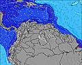 | 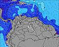 |  | 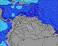 | 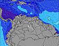 |  |  | |||||||||||||||
Onda Altezza (m) Direzione Periodo (s) | ENE 7 | E 7 | ENE 7 | E 7 | E 7 | E 7 | E 7 | E 7 | E 7 | E 7 | E 7 | E 7 | E 7 | E 7 | E 7 | ENE 7 | ENE 7 | ENE 7 | ENE 7 | ENE 7 | ENE 7 | ENE 7 | ENE 7 | ENE 7 |
Grafico delle onde | ||||||||||||||||||||||||
114 | 109 | 117 | 109 | 131 | 131 | 146 | 138 | 114 | 114 | 117 | 120 | 120 | 142 | 138 | 161 | 166 | 171 | 176 | 181 | 186 | 220 | 270 | 330 | |
Vento (km/h) | ||||||||||||||||||||||||
Stato del vento onshore cross-onshore cross-shore cross-offshore offshore piatto | off | off | off | cross-off | cross-off | off | off | off | off | off | off | cross-off | cross-off | cross-off | cross-off | cross-off | cross-off | cross-off | cross-off | cross-off | cross-off | cross-off | cross-off | cross-off |
Alta Marea | 4:49PM0.79m | 4:25AM1.01m | 5:31PM0.82m | 5:15AM0.97m | 6:11PM0.83m | 6:05AM0.90m | ||||||||||||||||||
Basso Marea | 10:25AM-0.01m | 10:12PM0.30m | 11:09AM0.03m | 11:04PM0.29m | 11:51AM0.10m | 11:57PM0.29m | ||||||||||||||||||
— | — | — | — | — | — | 5:48 | — | — | — | — | — | — | — | 5:48 | — | — | — | — | — | — | — | 5:48 | — | |
— | — | 6:30 | — | — | — | — | — | — | — | 6:30 | — | — | — | — | — | — | — | 6:30 | — | — | — | — | 6:30 | |
mm | — | — | — | — | — | — | — | — | — | — | — | — | — | — | — | — | 1 | — | — | — | — | 1 | 1 | 1 |
Temp. °C | 27 | 27 | 27 | 27 | 26 | 26 | 26 | 26 | 26 | 27 | 27 | 27 | 27 | 26 | 26 | 26 | 26 | 27 | 27 | 26 | 26 | 26 | 26 | 26 |
Gelo °C | 28 | 28 | 28 | 28 | 26 | 25 | 25 | 26 | 25 | 27 | 28 | 27 | 27 | 26 | 25 | 25 | 25 | 27 | 27 | 26 | 26 | 24 | 24 | 25 |
Onda 1 Altezza (m) Direzione Periodo (s) | N 10 | N 10 | ESE 7 | N 10 | N 10 | N 10 | N 9 | N 9 | N 9 | N 9 | N 9 | N 9 | N 9 | N 9 | N 9 | N 9 | N 9 | N 9 | N 8 | N 9 | N 9 | N 9 | N 9 | N 9 |
8 | 8 | 5 | 8 | 7 | 7 | 7 | 2 | 2 | 2 | 2 | 2 | 2 | 2 | 2 | 2 | 2 | 2 | 1 | 1 | 2 | 2 | 2 | 2 | |
Onda 2 Altezza (m) Direzione Periodo (s) | SE 8 | E 8 | N 10 | SE 8 | — | — | — | — | — | — | N 9 | N 9 | N 7 | — | N 7 | — | — | — | — | — | — | — | — | — |
2 | 1 | 8 | 2 | — | — | — | — | — | — | 2 | 2 | 1 | — | 1 | — | — | — | — | — | — | — | — | — | |
Onda 3 Altezza (m) Direzione Periodo (s) | — | N 8 | — | — | — | — | — | — | — | — | — | — | — | — | — | — | — | — | — | — | — | — | — | — |
— | 1 | — | — | — | — | — | — | — | — | — | — | — | — | — | — | — | — | — | — | — | — | — | — | |
onde vento Altezza (m) Direzione Periodo (s) | ENE 7 | E 7 | ENE 7 | E 7 | E 7 | E 7 | E 7 | E 7 | E 7 | E 7 | E 7 | E 7 | E 7 | E 7 | E 7 | ENE 7 | ENE 7 | ENE 7 | ENE 7 | ENE 7 | ENE 7 | ENE 7 | ENE 7 | ENE 7 |
114 | 109 | 117 | 109 | 131 | 131 | 146 | 138 | 114 | 114 | 117 | 120 | 120 | 142 | 138 | 161 | 166 | 171 | 176 | 181 | 186 | 220 | 270 | 330 | |
Il più vicino Offshore or Glassy | ||||||||||||||||||||||||
Distanza (km) | 0 | 0 | 0 | 253 | 140 | 253 | 64 | 64 | 585 | 0 | 0 | 140 | 140 | 140 | 140 | 585 | 673 | 673 | 140 | 140 | 140 | 267 | 585 | 629 |
Migliori previsioni per le condizioni d'onda in Tobago | ||||||||||||||||||||||||
Migliori previsioni per le condizioni d'onda in Trinidad and Tobago | ||||||||||||||||||||||||
Trova Onde Globale | ||||||||||||||||||||||||
- Map Icons:
 Break
Break Live Wave Height (m)
 Live Wind Speed (km/h)
 Surf Rating (10 Max)
 Ocean Swells (m)
- Wind Speed (km/h)
Widget Free Surf-Forecast.com per il tuo sito
La relazione di surf / widget meteo è disponibile qui sotto per incorporare su siti esterni a titolo gratuito e fornisce una sintesi delle nostre Sunset previsione surf. Basta prendere il frammento di codice html da noi fornito e copiarlo nel proprio sito. È possibile scegliere la lingua preferita e unità metriche / imperiali per il feed delle previsioni surf per soddisfare le esigenze degli utenti del vostro sito .... Clicca qui per ottenere il codice.
 Nearest