
Previsioni:

Previsione a breve terminePioggia moderata (Totale 16mm), più pesante Lunedì mattina. Warm (Max 27°C Lunedì pomeriggio, Min 24°C mercoledì notte). Venti in aumento (calma martedì mattina, venti freschi da SSE per mercoledì notte). | |||||||||||||||||||||||
Lunedì 3 | Martedì 4 | Mercoledì 5 | |||||||||||||||||||||
4 AM | 7 AM | 10 AM | 1 PM | 4 PM | 7 PM | 10 PM | 1 AM | 4 AM | 7 AM | 10 AM | 1 PM | 4 PM | 7 PM | 10 PM | 1 AM | 4 AM | 7 AM | 10 AM | 1 PM | 4 PM | 7 PM | 10 PM | |
Mappa dell'altezza del moto ondoso |  |  |  |  | 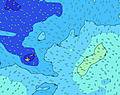 |  |  | 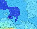 |  | ||||||||||||||
Onda Altezza (m) Direzione Periodo (s) | SSE 11 | SSE 11 | SW 15 | SW 15 | SSE 11 | SW 14 | SW 14 | SW 14 | SW 14 | SW 13 | SW 13 | SW 13 | SW 13 | SW 13 | SW 13 | SW 13 | SW 12 | SW 12 | SSW 12 | SSW 13 | SW 12 | SW 19 | SW 18 |
Grafico delle onde | |||||||||||||||||||||||
400 | 426 | 365 | 355 | 346 | 407 | 401 | 390 | 357 | 392 | 444 | 444 | 437 | 437 | 480 | 459 | 346 | 444 | 582 | 507 | 463 | 427 | 494 | |
Vento (km/h) | |||||||||||||||||||||||
Stato del vento onshore cross-onshore cross-shore cross-offshore offshore piatto | cross-off | cross-off | cross-off | cross-off | cross-off | cross-off | cross-off | off | glassy | cross-off | glassy | cross-on | on | on | cross-on | cross-on | cross-on | cross-on | cross-on | cross-on | cross-on | cross-on | cross-on |
Alta Marea | 9:31AM0.95m | 10:04PM0.94m | 10:20AM0.91m | 10:54PM0.95m | 11:17AM0.88m | ||||||||||||||||||
Basso Marea | 3:19AM0.26m | 3:44PM0.22m | 4:09AM0.27m | 4:29PM0.23m | 5:06AM0.27m | 5:22PM0.24m | |||||||||||||||||
6:47 | — | — | — | — | — | — | — | 6:47 | — | — | — | — | — | — | — | 6:46 | — | — | — | — | — | — | |
— | — | — | — | 6:17 | — | — | — | — | — | — | — | 6:17 | — | — | — | — | — | — | — | 6:17 | — | — | |
mm | 2 | 3 | 2 | — | 1 | 1 | — | 1 | — | — | — | — | — | — | — | — | — | — | 1 | 1 | 1 | 1 | 1 |
Temp. °C | 26 | 26 | 26 | 26 | 27 | 27 | 27 | 26 | 26 | 26 | 26 | 26 | 26 | 25 | 25 | 25 | 25 | 25 | 25 | 25 | 25 | 25 | 25 |
Gelo °C | 27 | 27 | 27 | 27 | 30 | 30 | 30 | 29 | 30 | 30 | 30 | 29 | 28 | 26 | 26 | 26 | 26 | 26 | 26 | 26 | 26 | 25 | 25 |
Onda 1 Altezza (m) Direzione Periodo (s) | SSE 11 | SSE 11 | SSE 11 | SSE 11 | SSE 11 | SE 11 | SE 11 | SE 11 | SW 14 | SW 13 | SW 13 | SW 13 | SW 13 | SW 13 | SW 13 | SW 13 | SW 12 | SW 12 | SSW 12 | SW 12 | SW 12 | SW 11 | SSW 12 |
400 | 426 | 335 | 335 | 341 | 293 | 288 | 288 | 357 | 392 | 444 | 444 | 437 | 437 | 480 | 459 | 341 | 444 | 582 | 442 | 463 | 418 | 494 | |
Onda 2 Altezza (m) Direzione Periodo (s) | SW 15 | SW 15 | SW 15 | SW 15 | E 8 | SW 14 | SW 14 | SW 14 | SE 11 | SE 12 | SE 10 | E 8 | SE 11 | SE 10 | S 15 | SSW 15 | SSW 14 | S 13 | S 13 | SSW 13 | SSW 12 | S 12 | SW 11 |
262 | 314 | 365 | 355 | 114 | 407 | 401 | 390 | 255 | 259 | 106 | 57 | 163 | 157 | 212 | 284 | 346 | 366 | 427 | 507 | 461 | 425 | 288 | |
Onda 3 Altezza (m) Direzione Periodo (s) | ENE 16 | ENE 16 | ENE 16 | ENE 15 | SW 14 | E 8 | E 8 | E 8 | E 8 | E 8 | E 8 | SE 10 | E 8 | E 8 | E 8 | SE 10 | E 8 | SE 10 | SE 10 | SE 11 | SE 11 | SW 19 | SW 18 |
25 | 25 | 24 | 21 | 346 | 89 | 92 | 72 | 72 | 55 | 57 | 100 | 58 | 42 | 42 | 108 | 43 | 85 | 89 | 110 | 134 | 427 | 481 | |
onde vento Altezza (m) Direzione Periodo (s) | E 8 | E 8 | E 8 | E 8 | — | — | — | — | — | — | — | — | S 4 | S 4 | SSE 10 | SSE 4 | SSE 10 | SSE 5 | E 8 | — | — | — | — |
124 | 149 | 138 | 135 | — | — | — | — | — | — | — | — | 5 | 5 | 225 | 23 | 260 | 39 | 80 | — | — | — | — | |
Il più vicino Offshore or Glassy | |||||||||||||||||||||||
Distanza (km) | 91 | 76 | 109 | 109 | 30 | 0 | 0 | 0 | 0 | 0 | 0 | 19 | 19 | 91 | 91 | 91 | 91 | 1265 | 1494 | 1494 | 91 | 91 | 1494 |
Migliori previsioni per le condizioni d'onda in Upolu | |||||||||||||||||||||||
Migliori previsioni per le condizioni d'onda in Samoa | |||||||||||||||||||||||
Trova Onde Globale | |||||||||||||||||||||||
- Map Icons:
 Break
Break Live Wave Height (m)
 Live Wind Speed (km/h)
 Surf Rating (10 Max)
 Ocean Swells (m)
- Wind Speed (km/h)
Widget Free Surf-Forecast.com per il tuo sito
La relazione di surf / widget meteo è disponibile qui sotto per incorporare su siti esterni a titolo gratuito e fornisce una sintesi delle nostre Tafatafa previsione surf. Basta prendere il frammento di codice html da noi fornito e copiarlo nel proprio sito. È possibile scegliere la lingua preferita e unità metriche / imperiali per il feed delle previsioni surf per soddisfare le esigenze degli utenti del vostro sito .... Clicca qui per ottenere il codice.
 Nearest