
Previsioni:

Previsione a breve terminePioggia abbondante (Totale 27mm), più pesante durante giovedì pomeriggio. Warm (Max 31°C Lunedì mattina, Min 26°C martedì notte). Venti in aumento (venti deboli da NNE Lunedì notte, venti freschi da NE per mercoledì notte). | ||||||||||||||||||||||||
Lunedì 3 | Martedì 4 | Mercoledì 5 | ||||||||||||||||||||||
12 AM | 3 AM | 6 AM | 9 AM | 12 PM | 3 PM | 6 PM | 9 PM | 12 AM | 3 AM | 6 AM | 9 AM | 12 PM | 3 PM | 6 PM | 9 PM | 12 AM | 3 AM | 6 AM | 9 AM | 12 PM | 3 PM | 6 PM | 9 PM | |
Mappa dell'altezza del moto ondoso |  |  |  |  | 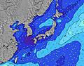 |  |  | 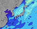 |  | |||||||||||||||
Onda Altezza (m) Direzione Periodo (s) | ESE 16 | ESE 15 | ESE 16 | ESE 16 | ESE 16 | ESE 16 | ESE 16 | ESE 16 | ESE 17 | ESE 17 | ESE 17 | ESE 17 | ESE 17 | ESE 17 | ESE 17 | ESE 17 | ESE 17 | ESE 17 | ESE 17 | ESE 17 | ESE 17 | ESE 18 | ESE 17 | ESE 17 |
Grafico delle onde | ||||||||||||||||||||||||
803 | 805 | 1224 | 1180 | 1714 | 1631 | 2424 | 2310 | 2680 | 3440 | 3440 | 5103 | 5209 | 6165 | 5188 | 7010 | 5988 | 8868 | 10857 | 12511 | 14081 | 17180 | 18670 | 22036 | |
Vento (km/h) | ||||||||||||||||||||||||
Stato del vento onshore cross-onshore cross-shore cross-offshore offshore piatto | glassy | off | cross-off | cross | cross | cross | cross | cross | cross-off | cross-off | cross-off | cross-off | cross | cross | cross | cross | cross | cross | cross | cross | cross | cross | cross | cross |
Alta Marea | 8:30AM1.75m | 9:03PM1.82m | 9:16AM1.66m | 9:33PM1.78m | 10:13AM1.55m | |||||||||||||||||||
Basso Marea | 2:37AM0.64m | 2:44PM0.46m | 3:16AM0.60m | 3:17PM0.63m | 4:02AM0.57m | 3:56PM0.82m | ||||||||||||||||||
— | 5:28 | — | — | — | — | — | — | — | 5:30 | — | — | — | — | — | — | — | 5:30 | — | — | — | — | — | — | |
— | — | — | — | — | — | 7:09 | — | — | — | — | — | — | — | 7:08 | — | — | — | — | — | — | — | 7:07 | — | |
mm | — | — | — | — | — | — | — | 2 | 2 | 1 | 1 | 1 | 2 | 3 | 2 | 2 | 1 | 2 | 3 | 1 | 1 | — | — | — |
Temp. °C | 30 | 29 | 29 | 31 | 31 | 31 | 30 | 28 | 27 | 27 | 27 | 28 | 29 | 29 | 28 | 27 | 27 | 27 | 26 | 27 | 29 | 29 | 28 | 27 |
Gelo °C | 34 | 33 | 33 | 34 | 33 | 34 | 33 | 32 | 31 | 31 | 31 | 31 | 32 | 32 | 32 | 30 | 30 | 30 | 28 | 29 | 30 | 30 | 30 | 29 |
Onda 1 Altezza (m) Direzione Periodo (s) | ESE 16 | ESE 15 | ESE 16 | ESE 16 | ESE 16 | ESE 16 | ESE 16 | ESE 16 | ESE 17 | ESE 17 | ESE 17 | ESE 17 | ESE 17 | ESE 17 | ESE 17 | ESE 17 | ESE 17 | ESE 17 | ESE 17 | ESE 17 | ESE 17 | ESE 18 | ESE 17 | ESE 17 |
803 | 805 | 1224 | 1180 | 1714 | 1631 | 2424 | 2310 | 2680 | 3440 | 3440 | 5103 | 5209 | 6165 | 5188 | 7010 | 5988 | 8868 | 10857 | 12511 | 14081 | 17180 | 18670 | 22036 | |
Onda 2 Altezza (m) Direzione Periodo (s) | E 10 | SE 10 | SSE 9 | SSE 9 | S 7 | S 7 | S 7 | E 6 | E 6 | E 7 | E 7 | — | — | — | E 9 | E 9 | E 9 | — | — | — | — | — | — | — |
48 | 15 | 8 | 8 | 4 | 1 | 1 | 73 | 119 | 158 | 205 | — | — | — | 450 | 505 | 450 | — | — | — | — | — | — | — | |
Onda 3 Altezza (m) Direzione Periodo (s) | SSE 10 | S 8 | S 8 | S 7 | — | — | — | S 12 | S 12 | — | — | — | — | — | — | — | — | — | — | — | — | — | — | — |
10 | 5 | 4 | 4 | — | — | — | 3 | 3 | — | — | — | — | — | — | — | — | — | — | — | — | — | — | — | |
onde vento Altezza (m) Direzione Periodo (s) | — | — | — | NNE 4 | NE 4 | ENE 4 | E 6 | E 6 | E 7 | E 7 | E 7 | E 8 | E 8 | E 8 | — | — | — | — | — | — | — | — | — | — |
— | — | — | 11 | 8 | 10 | 75 | 109 | 173 | 217 | 269 | 328 | 378 | 438 | — | — | — | — | — | — | — | — | — | — | |
Il più vicino Offshore or Glassy | ||||||||||||||||||||||||
Distanza (km) | 0 | 0 | 0 | 80 | 87 | 87 | 87 | 37 | 0 | 0 | 0 | 10 | 87 | 87 | 87 | 87 | 87 | 87 | 87 | 259 | 334 | 80 | 80 | 259 |
Migliori previsioni per le condizioni d'onda in Kyu Shu | ||||||||||||||||||||||||
Migliori previsioni per le condizioni d'onda in Japan | ||||||||||||||||||||||||
Trova Onde Globale | ||||||||||||||||||||||||
- Map Icons:
 Break
Break Live Wave Height (m)
 Live Wind Speed (km/h)
 Surf Rating (10 Max)
 Ocean Swells (m)
- Wind Speed (km/h)
Widget Free Surf-Forecast.com per il tuo sito
La relazione di surf / widget meteo è disponibile qui sotto per incorporare su siti esterni a titolo gratuito e fornisce una sintesi delle nostre Takanabe previsione surf. Basta prendere il frammento di codice html da noi fornito e copiarlo nel proprio sito. È possibile scegliere la lingua preferita e unità metriche / imperiali per il feed delle previsioni surf per soddisfare le esigenze degli utenti del vostro sito .... Clicca qui per ottenere il codice.
 Nearest