

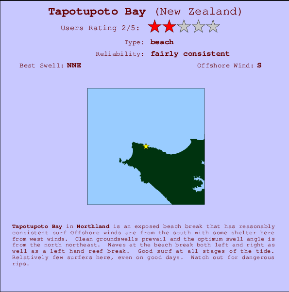
Tapotupoto Bay Surf Guide
Tapotupoto Bay in Northland is an exposed beach break that has consistent surf Works best in offshore winds from the south. Tends to receive distant groundswells and the ideal swell angle is from the north northeast. Waves at the beach break both left and right. Unlikely to be too crowded, even when the surf is up. Take care of .
Tapotupoto Bay Spot Info
| Type: | Rating: | Reliability: | Todays Sea Temp*: |
|---|---|---|---|
| fairly consistent | 16.4°C*ocean temperature recorded from satellite |
Surfing Tapotupoto Bay:
The best conditions reported for surf at Tapotupoto Bay occur when a North-northeast swell combines with an offshore wind direction from the South.

Previsioni Energia d'onda (Potenza): 12hrs


Tapotupoto Bay Surf:
Saturday, 18 July 2026, 21:19 Local time| Domenica 19 | ||||
| 9PM | 0AM | 3AM | 6AM | |
| Wave (m) | ||||
| Periodo (s) | 14 | 14 | 14 | 14 |
| Vento (km/h) | ||||
| Stato del vento | off | off | off | off |
- /breaks/Tapotupoto-Bay/forecasts/latest
Tapotupoto Bay Surf Guide
Tapotupoto Bay in Northland is an exposed beach break that has consistent surf Works best in offshore winds from the south. Tends to receive distant groundswells and the ideal swell angle is from the north northeast. Waves at the beach break both left and right. Unlikely to be too crowded, even when the surf is up. Take care of .
Tapotupoto Bay Spot Info
Type: Rating: Reliability: Todays Sea Temp*:  Beach
Beach 2
2fairly consistent 16.4°C*ocean temperature recorded from satelliteSurfing Tapotupoto Bay:
The best conditions reported for surf at Tapotupoto Bay occur when a North-northeast swell combines with an offshore wind direction from the South.
Previsioni Energia d'onda (Potenza): 12hrs
Utilizzare la scheda di navigazione in alto per visualizzare Tapotupoto Bay temperatura del mare, Tapotupoto Bay fotografie, Tapotupoto Bay dettagliate previsioni onde, il vento e le previsioni meteo, Tapotupoto Bay webcam, vento corrente da Northland stazioni meteo e Tapotupoto Bay previsioni marea. Il link New Zealand mappe maree apre l'immagine grande, che mostra New Zealand e dei mari circostanti. Queste mappe possono essere animate per mostrare le diverse componenti del moto ondoso, energia delle onde, periodo d'onda, altezza delle onde, insieme con le previsioni del vento e meteo, meteo corrente e osservazioni sullo stato del mare dal New Zealand onda-boe, le navi passanti e stazioni meteo costiere. Ciascuna delle pagine di previsioni per questo surf break rappresenta uno strumento di wavefinder globale e regionale per individuare le migliori condizioni di surf nella zona intorno Tapotupoto Bay.
Tapotupoto Bay Surf:
Saturday, 18 July 2026, 21:19 Local timeDomenica 19 9PM 0AM 3AM 6AM Wave (m) Periodo (s) 14 14 14 14 Vento (km/h) Stato del vento off off off off - /breaks/Tapotupoto-Bay/forecasts/latest
- /breaks/Tapotupoto-Bay/forecasts/latest/six_day
Tapotupoto Bay Surf Guide
Tapotupoto Bay in Northland is an exposed beach break that has consistent surf Works best in offshore winds from the south. Tends to receive distant groundswells and the ideal swell angle is from the north northeast. Waves at the beach break both left and right. Unlikely to be too crowded, even when the surf is up. Take care of .
Tapotupoto Bay Spot Info
Type: Rating: Reliability: Todays Sea Temp*: Beach2fairly consistent 16.4°C*ocean temperature recorded from satelliteSurfing Tapotupoto Bay:
The best conditions reported for surf at Tapotupoto Bay occur when a North-northeast swell combines with an offshore wind direction from the South.
Previsioni Energia d'onda (Potenza): 12hrs
Utilizzare la scheda di navigazione in alto per visualizzare Tapotupoto Bay temperatura del mare, Tapotupoto Bay fotografie, Tapotupoto Bay dettagliate previsioni onde, il vento e le previsioni meteo, Tapotupoto Bay webcam, vento corrente da Northland stazioni meteo e Tapotupoto Bay previsioni marea. Il link New Zealand mappe maree apre l'immagine grande, che mostra New Zealand e dei mari circostanti. Queste mappe possono essere animate per mostrare le diverse componenti del moto ondoso, energia delle onde, periodo d'onda, altezza delle onde, insieme con le previsioni del vento e meteo, meteo corrente e osservazioni sullo stato del mare dal New Zealand onda-boe, le navi passanti e stazioni meteo costiere. Ciascuna delle pagine di previsioni per questo surf break rappresenta uno strumento di wavefinder globale e regionale per individuare le migliori condizioni di surf nella zona intorno Tapotupoto Bay.
Tapotupoto Bay Surf:
Saturday, 18 July 2026, 21:19 Local timeDomenica 19 9PM 0AM 3AM 6AM Wave (m) Periodo (s) 14 14 14 14 Vento (km/h) Stato del vento off off off off - /breaks/Tapotupoto-Bay/forecasts/latest
Tapotupoto Bay Surf Guide
Tapotupoto Bay in Northland is an exposed beach break that has consistent surf Works best in offshore winds from the south. Tends to receive distant groundswells and the ideal swell angle is from the north northeast. Waves at the beach break both left and right. Unlikely to be too crowded, even when the surf is up. Take care of .
Tapotupoto Bay Spot Info
Type: Rating: Reliability: Todays Sea Temp*: Beach2fairly consistent 16.4°C*ocean temperature recorded from satelliteSurfing Tapotupoto Bay:
The best conditions reported for surf at Tapotupoto Bay occur when a North-northeast swell combines with an offshore wind direction from the South.
Previsioni Energia d'onda (Potenza): 12hrs
Utilizzare la scheda di navigazione in alto per visualizzare Tapotupoto Bay temperatura del mare, Tapotupoto Bay fotografie, Tapotupoto Bay dettagliate previsioni onde, il vento e le previsioni meteo, Tapotupoto Bay webcam, vento corrente da Northland stazioni meteo e Tapotupoto Bay previsioni marea. Il link New Zealand mappe maree apre l'immagine grande, che mostra New Zealand e dei mari circostanti. Queste mappe possono essere animate per mostrare le diverse componenti del moto ondoso, energia delle onde, periodo d'onda, altezza delle onde, insieme con le previsioni del vento e meteo, meteo corrente e osservazioni sullo stato del mare dal New Zealand onda-boe, le navi passanti e stazioni meteo costiere. Ciascuna delle pagine di previsioni per questo surf break rappresenta uno strumento di wavefinder globale e regionale per individuare le migliori condizioni di surf nella zona intorno Tapotupoto Bay.
Tapotupoto Bay Surf:
Saturday, 18 July 2026, 21:19 Local timeDomenica 19 9PM 0AM 3AM 6AM Wave (m) Periodo (s) 14 14 14 14 Vento (km/h) Stato del vento off off off off Tide Times:
Per Cape Maria van Diemen, New Zealand, %{dist} %{km} da %{location}.
PROSSIMA È ALLE (ora locale) rimanente alta marea bassa marea Tapotupoto Bay Tide Times and Tide Chart
Live Weather:
At Aupouri, 40 km from Tapotupoto Bay.
light winds from the S
(km/h)
DryAir temperature
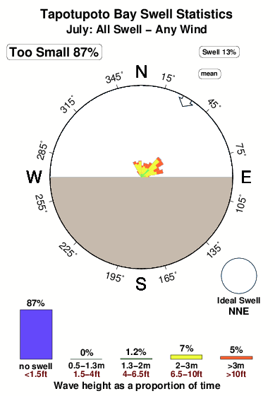
11°COverall Tapotupoto Bay Surf Consistency and Wind Distribution in Luglio
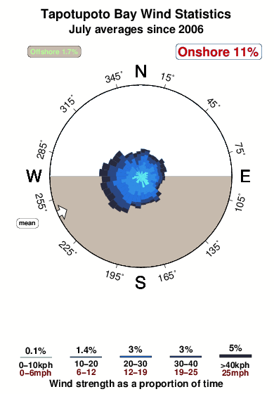


Wind stats for Tapotupoto Bay: see the variation in direction and stength by month.
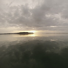
foto dall' album
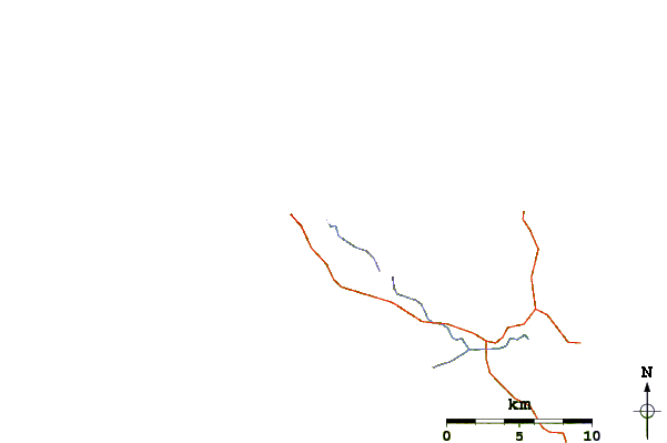
Contorni: Strade e fiumi: seleziona un surf break dal menu 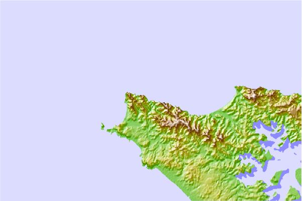

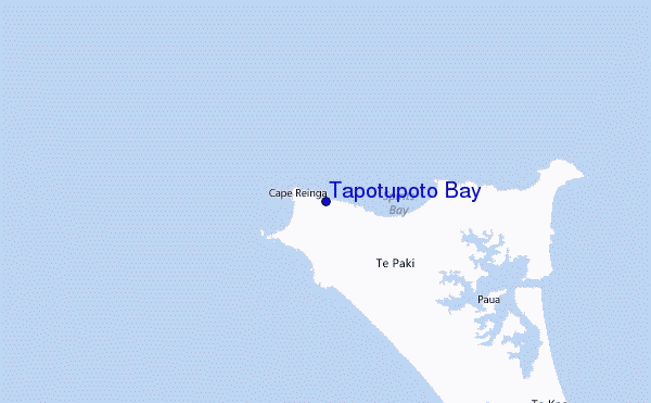
Utilizzare questa mappa sollievo per navigare Northland surf breaks e stazioni di marea che si trovano nella zona diTapotupoto Bay
Altri surf breaks più vicini al Tapotupoto Bay:
(clicca sul nome del luogo per maggiori informazioni)- Closest località surf2 mi
- Second closest località surf4 mi
- Third closest località surf6 mi
- Fourth closest località surf7 mi
- Fifth closest località surf7 mi
Onda boe più vicina a Tapotupoto Bay:
- Closest Onda boa144 mi
- Second closest Onda boa313 mi
- Third closest Onda boa432 mi
- Fourth closest Onda boa472 mi
- Fifth closest Onda boa477 mi
Stazioni di marea più vicina alla Tapotupoto Bay:
- Closest marea stazioneCape Maria van Diemen6 mi
- Second closest marea stazioneTe Hapua17 mi
- Third closest marea stazioneHouhora Harbour (Pukenui Wharf)35 mi
- Fourth closest marea stazioneHouhora River Entrance37 mi
- Fifth closest marea stazioneThree Kings Islands (North West Bay)38 mi
Airports
- The nearest passenger airport to Tapotupoto Bay is Kaitaia Airport (KAT) in New Zealand, which is 87 km (54 miles) away (directly).
- The second closest airport to Tapotupoto Bay is Kerikeri Airport (KKE), also in New Zealand, 143 km (89 miles) away.
- /breaks/Tapotupoto-Bay/forecasts/latest
 Nearest